
The City of Swan is a local government area of Western Australia. It is in the eastern metropolitan region of Perth and includes the Swan Valley and 42 suburbs. It is centred approximately 20 km north-east of the Perth central business district. The City covers an area of 1,042 km² and had an estimated population of 155,653 in 2020.
South Ockendon is a town, former civil parish and Church of England parish within the Thurrock borough in Essex in the East of England, United Kingdom. It is located on the border with Greater London, just outside the M25 motorway. The area to the north is North Ockendon. In 2019 it had an estimated population of 22,303. In 1931 the parish had a population of 1355.

The Division of Hasluck is an electoral division of the Australian House of Representatives, located in Western Australia.
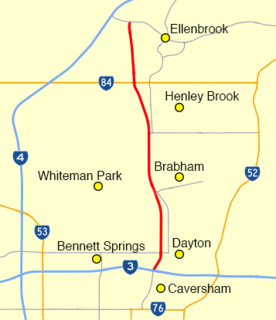
The Swan Valley is a region in the upper reaches of the Swan River between Guildford and Bells Rapids, Western Australia. It is bordered to the east by the Darling Scarp. Both Ellenbrook and Jane Brook lie within the region and discharge into the Swan River. There are seven suburbs within the region: Baskerville, Belhus, Caversham, Henley Brook, Herne Hill, Millendon and West Swan. It is part of the City of Swan local government area.
Landsdale is a northern suburb of Perth, Western Australia located within the local government area of the City of Wanneroo. It is mixed use, with residential, commercial and light manufacturing areas.

Belhus is a suburb of Perth, Western Australia. It is in the City of Swan local government area. It was named after Belhus Estate, the original English estate owned by the family of Edmund Barrett-Lennard, one of the pioneers of the Swan Valley table grape industry, who bought a property in the area in 1897 and named it "Belhus".

Ellenbrook is a northeastern suburb of Perth, Western Australia, about 30 km (19 mi) from Perth's central business district (CBD), located within the City of Swan. Ellenbrook, and its neighbouring suburbs of The Vines and Aveley, are unusual for Perth in being a significant distance from neighbouring suburbs. Given this relative isolation and the distance from the CBD, Ellenbrook has been designed and developed as a self-sustainable community. Since the upgrade of Gnangara Road and the completion of the Tonkin Highway Northlink, access to Ellenbrook has improved. The Morley–Ellenbrook railway line is well underway as at June 2021 and this will enable better public transport. At the time of the 2016 census there were 22,681 people living in the gazetted suburb, by June 2018, it was estimated that the urban population for Ellenbrook and surrounds had grown to 41,382. It is envisioned that Ellenbrook will eventually become a satellite city, with a population of 80,000.

Tonkin Highway is an 81-kilometre-long (50 mi) north–south highway and partial freeway in Perth, Western Australia, linking Perth Airport and Kewdale with the city's north-eastern and south-eastern suburbs. As of April 2020, the northern terminus is at the interchange with Brand Highway and Great Northern Highway in Muchea, and the southern terminus is at Thomas Road in Oakford. It forms the entire length of State Route 4, and connects to several major roads. Besides Brand Highway and Great Northern Highway, it also connects to Reid Highway, Great Eastern Highway, Leach Highway, Roe Highway, and Albany Highway.

Swan Hills is an electoral district of the Legislative Assembly in the Australian state of Western Australia.

Cullacabardee is a northeastern rural suburb of Perth, the capital city of Western Australia, located 21 km (13 mi) from Perth's central business district via Alexander Drive or Beechboro Road. It is in the City of Swan local government area. Most of the suburb is covered in native sheoak and banksia forest. A small Noongar community is based on Baal Street, a drug rehabilitation retreat is located off Gnangara Road in the suburb's northeast, and the Perth International Telecommunications Centre facility is based in the suburb's northwest.

Alexander Drive is a major north–south arterial road in the northern suburbs of Perth, Western Australia, connecting Perth's central business district (CBD) with Edith Cowan University's Mount Lawley campus and the Malaga industrial area, as well as newer development suburbs to Perth's north. It is used by Transperth bus routes, including the 360, 361 and 362. Alexander Drive was named after Mr S.B. Alexander, a former Wanneroo Road Board member. Alexander Drive runs through the following local government areas City of Wanneroo, City of Swan, City of Bayswater and City of Stirling.

Beechboro Road is a north–south arterial road located in the northeastern suburbs of Perth, Western Australia, connecting Morley and Bayswater with areas further north. Until the construction of the nearby section of Tonkin Highway between 1984 and 1992, and later, during the NorthLink WA road project between 2016 and 2019, Beechboro Road was one of northeastern Perth's most important routes. The road is discontinuous at Tonkin Highway, with the section from Tonkin Highway to Walter Road officially known as Beechboro Road North, and the section running through Bayswater as Beechboro Road South.

Belhus is a golf course, country park, former stately home and manor in the parish of Aveley in Essex, England. The historic manor was known in ancient times variously as "Bellhouse, Belhouse, Bell House", etc. It is now an integral part of the Thames Chase woodland planned for the area.
Brabham is a suburb located about 21 km (13 mi) north-east of Perth's central business district. The suburb is located in the City of Swan just south of Henley Brook, formerly being a part of that suburb before it was gazetted in May 2011. The suburb was named after Australian motor racing personality Sir Jack Brabham who competed in the 1962 Australian Grand Prix, held at the nearby Caversham Airfield. The suburb is part of the City of Swan's urban growth corridor and is bordered by Park Street to the north, Murray Street to the east, Harrow Street to the south and Drumpellier Drive and Isoondon Street to the west. It is located in the Whiteman Ward of the City of Swan.

Gnangara Road is an arterial east-west road in Perth, Western Australia. It is located within the northern suburbs of Perth, from Madeley in the west, to Henley Brook in the east. Gnangara Road provides a connection between Great Northern Highway and Wanneroo Road. The construction of the Ocean Reef Road extension in 2011 altered the road network in the Landsdale area in Landsdale. The plans show Gnangara Road as discontinuous between Mirrabooka Avenue and Alexander Drive, with the Mirrabooka Avenue and Ocean Reef Road extensions linking the two sections. Following construction, those linking road sections were named as Gnangara Road, allowing the road to remain continuous.

Ellenbrook Transfer Station was a Transperth bus station located on the corner of Lord Street and Gnangara Road, in Ellenbrook. It had 3 stands and was served by 7 Transperth routes operated by Swan Transit.

Ellen Brook is an ephemeral stream which runs from south of Gingin to the Swan River in Western Australia.

Ellenbrook Secondary College is an Independent public co-educational high day school, located in the Perth suburb of Ellenbrook.

Aveley Secondary College is an Independent public co-educational high day school, located in the Perth suburb of Ellenbrook, just north of Aveley, Western Australia.
Drumpellier Drive is a north-south road linking Ellenbrook with Reid Highway in the north-eastern suburbs of Perth. The southern section was opened as Lord Street, and was the main link between Ellenbrook and the rest of Perth until the extension of Tonkin Highway north to Gnangara Road. The road corridor has had several proposals put forward for it, including a highway, a bus rapid transit road and a railway. In 2019, a new alignment for Lord Street south of Gnangara Road opened, and it was renamed to Drumpellier Drive, making the naming consistent with the section of road north of Gnangara Road.
