
San Pedro Sula is the capital of Cortés Department, Honduras. It is located in the northwest corner of the country in the Sula Valley, about 50 kilometres (31 mi) south of Puerto Cortés on the Caribbean Sea. With a census population of 719,063 in 2013, and 1,445,598 people living in its metropolitan area in 2010, it is the nation's primary industrial center and second largest city after the capital Tegucigalpa.

Querétaro, officially the Free and Sovereign State of Querétaro, is one of the 32 federal entities of Mexico. It is divided into 18 municipalities. Its capital city is Santiago de Querétaro.

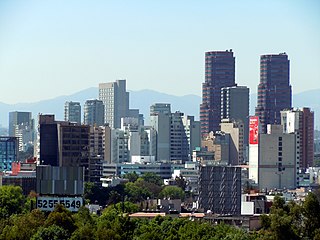
Miguel Hidalgo is one of the 16 delegaciones (boroughs) into which Federal District of Mexico City is divided. It was created in 1970, joining the historic areas of Tacuba, Chapultepec and Tacubaya along with a number of notable neighborhoods such as Polanco and Lomas de Chapultepec. With landmarks such as Chapultepec Park and the Museo Nacional de Antropología, it is the second most visited borough in Mexico City after Cuauhtémoc, D.F. where the historic center of Mexico City is located. Tacubaya and Tacuba both have long histories as independent settlements and were designated as “Barrios Mágicos” by the city for tourism purposes.

State Route 99 (SR 99), commonly known as Highway 99 or, simply, as 99, is a north–south state highway in the U.S. state of California, stretching almost the entire length of the Central Valley. From its southern end at Interstate 5 (I-5) near Wheeler Ridge to its northern end at SR 36 near Red Bluff, SR 99 goes through the densely populated eastern parts of the valley. Cities served include Bakersfield, Delano, Tulare, Visalia, Kingsburg, Selma, Fresno, Madera, Merced, Turlock, Modesto, Stockton, Sacramento, Yuba City, and Chico.

The local-express lane system is an arrangement of carriageways within a major highway where long distance traffic can use lanes with fewer interchanges compared to local traffic which use 'local' or 'collector' lanes that have access to all interchanges. This can also be called collector–distributor lanes within a single interchange. Where highway ramps between express and local/collector lanes cross over one another this is commonly known as braided ramps. One of the longest examples is Ontario Highway 401 between Etobicoke and Pickering in Canada.

The Mexico City Metrobús is a bus rapid transit (BRT) system that has served Mexico City since line 1 opened on June 19, 2006. As of February 2018, it consists of seven lines that cross the city and connect with other forms of transit, such as the Mexico City Metro. The most recent line to open was line 7, running for the first time double-decker buses along the city's iconic boulevard, Paseo de la Reforma.

Colonia Roma, also called La Roma or simply, Roma, is a district located in the Cuauhtémoc borough of Mexico City just west of the city’s historic center, and in fact is no longer a single colonia (neighbourhood) but now two officially defined ones, Roma Norte and Roma Sur, divided by Coahuila street.

El Puerto de Liverpool S.A.B. de C.V., commonly known as Liverpool, is a mid-to-high end retailer which operates the largest chain of department stores in Mexico, operating 23 shopping malls including Perisur and Galerías Monterrey. Its 85 department stores comprise 73 stores under the Liverpool name and 22 stores under the Fábricas de Francia name. It also operates 6 Duty Free stores and 27 specialized boutiques.

Avenida Presidente Masaryk is a thoroughfare in the affluent Polanco neighborhood of Mexico City. It stretches from Calzada General Mariano Escobedo in the east to Avenida Ferrocarril de Cuernavaca in the west, passing along the north side of the Polanquito restaurant district that borders Parque Lincoln. Masaryk is of the most expensive shopping districts in the world and competes with Avenida Madero in the Historic Center for the title of street with the highest rents in the city.

Avenida General Paz is a beltway freeway surrounding the city of Buenos Aires. Roughly following the boundary between the city and Buenos Aires Province, it is one of the few motorways in Argentina that is toll-free. It carries three lanes of traffic in each direction during most of its length, and five lanes between the Pan-American Highway and the Río de la Plata. There are feeder roads in both directions and there are service areas along its length, usually with a gas station and fast food restaurants.
Interstate 5 (I-5) is a major north–south route of the Interstate Highway System in the U.S. state of California. It begins at the Mexico–United States border at the San Ysidro crossing, goes north across the length of California and crosses into Oregon south of the Medford-Ashland metropolitan area. It is the more important and most used of the two major north-south routes on the Pacific Coast, the other being U.S. Route 101, which is primarily coastal.
Polanco is the main urban upscale district in Mexico City, part of the Miguel Hidalgo borough, located north of Chapultepec Park and consisting of five official neighborhoods ("colonias").

Condesa or La Condesa is an area in the Cuauhtémoc Borough of Mexico City, south of the Zona Rosa and 4 to 5 km west of the Zócalo, the city's main square. It is immediately west of Colonia Roma, together with which it is designated as a "Barrio Mágico Turístico". Together they are often referred to as Condesa–Roma, one of the most architecturally significant and bastion of the creative communities of the city.

Gente Nueva, also known as Los Chapos, in reference to their drug lord Joaquín Guzmán Loera, was a group of hitmen that works as the armed wing of the Sinaloa Cartel, created to counter the Juárez Cartel influence in the Mexican north-west.

On 7 May 2013, a tanker truck carrying liquefied petroleum gas lost control and ran into several cars and houses before it exploded on Federal Highway 85 in San Pedro Xalostoc community in Ecatepec de Morelos, Mexico. 27 people were killed and more than 30 injured as a result of the accident. The resulting fires damaged 45 homes and 16 vehicles.

The Circuito Interior Bicentenario or more commonly, Circuito Interior or even more simply Circuito, is a 42-km-long urban freeway and at-grade boulevard, forming a loop around the central neighborhoods of Mexico City. It was built starting in 1961. The Circuito Interior received the appellation Bicentenario (Bicentennial) after a renovation that took place in 2010, Mexico's bicentennial year.

EcoBici is the bicycle sharing system launched in February 2010 by the government of Mexico City. Initially launched with 85 docking stations and 1,000 distinctive red and white liveried bicycles, the network then expanded by September 2013 to be at 276 stations with 4,000 bicycles, and as of April 2015, now has 444 stations with 6,000 bicycles.

Mixcoac is an area of southern Mexico City which used to be a separate town and municipality within the Mexican Federal District until it was made part of Mexico City proper in 1928. Mixcoac consists of the colonias of Nonoalco, San Juan, Extremadura Insurgentes, Mixcoac and Insurgentes Mixcoac and is part of the borough of Benito Juárez. It is bounded by Avenida de los Insurgentes to the east and the Periférico freeway to the west, south of Colonia Nápoles and San Pedro de los Pinos.

The Toluca–Mexico City commuter rail project is a 57.7 km (35.9 mi) commuter rail line currently under construction. Also known as Interurban Train Mexico City–Toluca, the passenger railway line will connect the cities of Toluca and Mexico City. The project was announced by President Enrique Peña Nieto on 1 December 2012. Construction began in July 2014. The line is scheduled to open in 2019. However, by December 2018, it was estimated to open around 2021.
Churrería El Moro is a restaurant serving churros and hot chocolate in Mexico City. The original 1935 location is on Eje Central Lázaro Cárdenas near the Metro San Juan de Letrán in the Historic center of Mexico City. Since 2014 the grandchildren of the original owner have opened branches in Palacio de Hierro department store food halls, in the Mercado Roma food hall, on Parque México in Condesa, on Avenida Álvaro Obregón in Colonia Roma, and in Colonia Cuauhtémoc along Río Lerma street, a restaurant row.


