
Bahia is one of the 26 states of Brazil, located in the Northeast Region of the country. It is the fourth-largest Brazilian state by population and the 5th-largest by area. Bahia's capital is the city of Salvador, on a spit of land separating the Bay of All Saints from the Atlantic. Once a monarchial stronghold dominated by agricultural, slaving, and ranching interests, Bahia is now a predominantly working-class industrial and agricultural state. The state is home to 7% of the Brazilian population and produces 4.2% of the country's GDP.
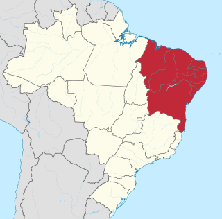
The Northeast Region of Brazil is one of the five official and political regions of the country according to the Brazilian Institute of Geography and Statistics. Of Brazil's twenty-six states, it comprises nine: Maranhão, Piauí, Ceará, Rio Grande do Norte, Paraíba, Pernambuco, Alagoas, Sergipe and Bahia, along with the Fernando de Noronha archipelago.
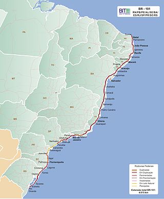
The BR-101 is a longitudinal highway of Brazil. It is the longest in the country with a length of nearly 4,800 km (3,000 mi), and it is considered one of the most important highways in the country, along with BR-116.
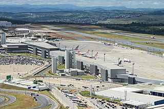
Belo Horizonte/Confins – Tancredo Neves International Airport, formerly called Confins International Airport is the primary international airport serving Belo Horizonte. Since 2 September 1986 the airport is named after Tancredo de Almeida Neves (1910–1985), President-elect of Brazil. It is located in the municipality of Confins, in the state of Minas Gerais. It is operated by BH Airport S.A.

Club Sportivo Sergipe, or Sergipe as they are usually called, is a Brazilian football team from Aracaju, the second oldest club in the state of Sergipe, founded on October 17, 1909. Club Sportivo Sergipe is the only team from Sergipe to have played against foreign opposition, having faced the Argentina youth team, Sparta Prague, Alianza Lima and the Ghana national team. Sergipe is the only team to have won six state championships in a row. Sergipe's main rival is Confiança. Sergipe's home field is the Estádio João Hora de Oliveira, capacity 8,000.
Nordeste Linhas Aéreas Regionais was a regional airline based in Brotas, Salvador, Bahia, Brazil which operated scheduled passenger services in northeast and southeast Brazil. Its main base was Deputado Luís Eduardo Magalhães International Airport, Salvador.
The highway system of São Paulo is the largest statewide road transportation system in Brazil, with 34,650 km. It consists of a hugely interconnected network of municipal (11,600 km), state (22,000 km) and federal (1,050 km) roads. More than 90% of the population is within 5 km of a paved road.

Salvador is a Brazilian municipality and capital city of the state of Bahia. Situated in the Zona da Mata in the Northeast Region of Brazil, Salvador is recognized throughout the country and internationally for its cuisine, music and architecture. The African influence in many cultural aspects of the city makes it a center of Afro-Brazilian culture. As the first capital of Colonial Brazil, the city is one of the oldest in the Americas and one of the first planned cities in the world, having been established during the Renaissance period. Its foundation in 1549 by Tomé de Sousa took place on account of the implementation of the General Government of Brazil by the Portuguese Empire.

Póvoa de Varzim' is served by a transportation network that employs maritime, aerial and terrestrial travel. The terrestrial access infrastructure is composed of national motorways (freeways), the national roads system, and light rail metro. These infrastructures and the airport, bus terminal, marina and harbour are daily used by commuters.

Héctor Julio Páride Bernabó was an Argentine-Brazilian artist, researcher, historian and journalist. His nickname Carybé, a type of piranha, comes from his time in the scouts. He died of heart failure after the meeting of the candomblé community's secular board of directors, the Cruz Santa Opô Afonjá Society, of which he was a member.
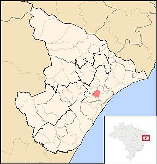
Maruim is a municipality located in the Brazilian state of Sergipe. Its population was 17,271 (2020) and covers 95.55 km2 (36.89 sq mi). Maruim has a population density of 180 inhabitants per square kilometer. It is located 30 km (19 mi) from the state capital of Sergipe, Aracaju. Maruim borders the municipalities of Laranjeiras, Rosário do Catete, and Santo Amaro das Brotas, all within the state of Sergipe.

The Salvador Metro is a rapid transit system serving Salvador city, the state capital of Bahia and the fourth largest city in Brazil. The current system includes a fully open 33 km and twenty, which began partial public service on June 11, 2014. The system arrives until the center of the city of Lauro de Freitas also. It is operated by CCR METRÔ BAHIA Company.

Mata de São João is a municipality in the state of Bahia in the North-East region of Brazil. It covers 605.17 km2 (233.66 sq mi) and a population of 47,126. Mata de São João has a population density of 73 inhabitants per square kilometer. It is located 56 km (35 mi) from the state capital of Bahia, Salvador.

Nazaré, also known as Nazaré das Farinhas, is a municipality in the state of Bahia in the North-East region of Brazil. The municipality has a population of 28,594 with a population density of 107 inhabitants per square kilometer. It is located 110 km (68 mi) from the state capital of Bahia, Salvador. Nazaré is within the Bahian Recôncavo, an interior region of the state of Bahia. It borders the municipalities of Muniz Ferreira, Aratuípe, Jaguaripe, São Felipe, and Maragogipe. The Jaguaripe River crosses through the middle of the town. It is sits on the intersection of two Bahian state highways, BA-001 and BA-046.
The Catholic University of Salvador is a private and non-profit Catholic university, located in Salvador, the first capital of Brazil, and fourth largest city of Brazil. It is maintained by the Catholic Archdiocese of Salvador.

The State of Brazil was one of the states of the Portuguese Empire, in the Americas during the period of Colonial Brazil.
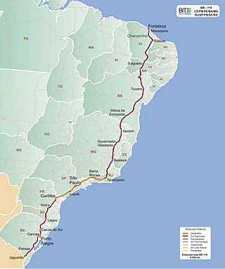
BR-116 is a federal route of highways of Brazil and the longest highway in the country, with 4,542 km (2,822 mi) of extension. The road connect Fortaleza, Ceará, one of the largest Northeast Brazil metropolises, to the southern city of Jaguarão, Rio Grande do Sul, in the border with Uruguay. It is also the longest highway in the country to be completely paved. It is considered one of the most important highways in the country, along with BR-101.
The Church of Our Lady of Nazareth of Engenho Itaperoá is an abandoned 18th-century Roman Catholic church in São Cristóvão, Sergipe, Brazil. It is also referred to as the Chapel of Our Lady of Nazareth of Engenho Itaperoá. The church is located on the former Fazenda Itaperoá, a sugarcane plantation, west of the city center São Cristóvão. The church belonged to the Parish of Our Lady of Victory, which included Santo Antônio and São Gonçalo, in Camassari. It was listed as a historic structure by the State of Sergipe in 1984; despite its heritage designation, the church is in advanced state of ruin.

The BR-235 is a Brazilian federal highway that connects the cities of Aracaju, in the state of Sergipe, to Novo Progresso, Pará. It has a total length of 2,093.5 km.

