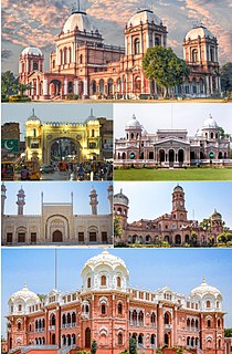
Bahawalpur (بہاولپور), is a city located in the Punjab province of Pakistan. Bahawalpur is the 11th largest city in Pakistan with an estimated population of 798,509.

Bahawalpur was a princely state of British India, and later Pakistan, that existed as an independent nation from 1947 to 1955. It was a part of Punjab States Agency. The state covered an area of 45,911 km2 (17,726 sq mi) and had a population of 1,341,209 in 1941. The capital of the state was the town of Bahawalpur.

The administrative units of Pakistan consist of four provinces, two autonomous territories and one federal territory. Each province and territory is subdivided into divisions, which are further subdivided into districts, which are further subdivided into tehsils, or taluka, which are further subdivided into union councils.

West Punjab was a province of Pakistan from 1947 to 1955. The province covered an area of 205,344 km2, including much of the current Punjab province and the Islamabad Capital Territory, but excluding the former princely state of Bahawalpur. The capital was the city of Lahore and the province was composed of four divisions. The province was bordered by the Indian states of East Punjab and Jammu and Kashmir to the east, the princely state of Bahawalpur to the south, the provinces of Balochistan and Sind to the southwest, Khyber-Pakhtunkhwa to the northwest, and Azad Kashmir to the northeast.
The Punjab region is an area of South Asia stretching from central and eastern Pakistan to northwest India.

Bahawalpur District is one of the districts of Punjab, Pakistan. Its capital is the city of Bahawalpur. According to the 1998 Census of Pakistan it had a population of 2,433,091, of which 27.01% were urban. Bahawalpur district covers 24,830 km². Approximately two-thirds of the district (16,000 km²) is covered by the Cholistan Desert, which extends into the Thar Desert of India. The district is a major producer of cotton.

Bahawalnagar, is the capital city of Bahawalnagar District situated in the south east region in the Punjab province of Pakistan. The town of Bahawalnagar is the headquarter of the district and tehsil as well. Old name of Bahawalnagar was Rojanwali/Ubbha. It was named Bahawalnagar in 1904 after Bahawal Khan V, the ruler of the Bahawalpur state comprising the present districts of Bahawalpur, Bahawalnagar and Rahim Yar Khan. It is 192 miles south of Lahore and about 120 miles east of Bahwalpur. River Sutlej passes on the northern side at a distance of about 6 miles.

{{Infobox settlement | name = Bahawalnagar | official_name = | native_name = بہاولنگر | native_name_lang = | settlement_type = District | image_skyline = | imagesize = | image_alt = | image_caption = | image_map = Pakistan - Punjab - Bahawalnagar.svg | mapsize = 200px | map_alt = | map_caption = Location of Bahawalnagar District within Punjab. | coordinates = | subdivision_type = Country | subdivision_name = Pakistan | subdivision_type1 = Province | subdivision_name1 = Punjab | subdivision_type2 = | subdivision_name2 = | founder = | seat_type = Headquarters | seat = Bahawalnagar | government_footnotes = | leader_party = | unit_pref = Metric | area_footnotes = | area_total_km2 = 8878 | population_footnotes = | population_as_of = 2017 | population_total = 2,981,919 | population_density_km2 = auto | timezone1 = PKT | utc_offset1 = +5 | established_title = Established | established_date = | leader_title = District Coordination Officer | leader_name = | leader_title1 = Members of National Assembly | leader_name1 = [[Mr. Muhammad Abdul Ghafar Wattoo]]
[[Mr. Alam Dad Lalika]]
[[Mr.Ihsan ul Haq Bajwa]]
[[Mr. Noor Ul Hassan Tanvir]] | blank_name_sec1 = No. of Tehsils | blank_info_sec1 = 5 | blank1_name_sec1 = Tehsils | blank1_info_sec1 = Bahawalnagar
Chishtian
Fort Abbas
Haroonabad
Minchinabad | demographics1_title1 = Main language(s) | demographics1_info1 = Punjabi and Urdu | website = }}

{{Infobox settlement | official_name = | name = Lodhran District | native_name = ضِلع لودھراں | native_name_lang = | settlement_type = District | image_skyline = | imagesize = | image_alt = | image_caption = | image_map = Pakistan - Punjab - Lodhran.svg | mapsize = 200px | map_alt = | map_caption = Map of Punjab with Lodhran District highlighted | latd = |latm = |lats = |latNS = | longd = |longm = |longs = |longEW = | coordinates_type = | coordinates_display = | subdivision_type = Country | subdivision_name = Pakistan | subdivision_type1 = Province | subdivision_name1 = Punjab | founder = | seat_type = Headquarters | seat = Lodhran city | government_footnotes = | leader_party = | unit_pref = Metric | area_footnotes = | area_total_km2 = 1790 | population_footnotes = | population_as_of = 2017 | population_total = 1,700,620 | population_density_km2 = auto | timezone1 = PST | utc_offset1 = +5 | established_title = Established | established_date = | leader_title = | leader_name = | leader_title1 = | leader_name1 = | blank_name_sec1 = District Council | blank_info_sec1 = | blank1_name_sec1 = Number of Tehsils | blank1_info_sec1 = 3 | demographics1_title1 = Main language(s) | demographics1_info1 = Saraiki [[Punjabi] [Urdu]] | website = lodhran.gop.pk }}
Khanpur is a city and Tehsil of the Rahim Yar Khan District of Bahawalpur Division, in the Punjab province of Pakistan.

Minchinabad, is a city of Bahawalnagar District in the Punjab province of Pakistan. The city is the capital of Minchinabad Tehsil. It underwent rapid development in the late 1860s and 1870s. The city is named after Colonel Charles Minchin, the British Political Agent overseeing the Bahawalpur Princely State from 1866-1876
Bahawalpur Saddar is a tehsil located in Bahawalpur District in the Pakistani province of Punjab. The city of Bahawalpur is the headquarters of the tehsil which is administratively subdivided into 36 Union Councils. The tehsil is traversed by the Hakra depression, south of which lies the desert. The north lies in the Sutlej riverain, and between this and the Hakra are the central uplands.

Allah Abad is a town and Union Council in Punjab, Pakistan. It is located in Tehsil Liaqatpur, the district of Rahim Yar Khan.

Bahawalpur Railway Station is located in Bahawalpur city, Bahawalpur district, Punjab province, Pakistan at the elevation of 385 ft. It is a major railway station of Pakistan Railways on Karachi-Peshawar main line.
Dera Nawab Sahib railway station ( is located in Ahmadpur East Tehsil, Bahawalpur district of Punjab province of the Pakistan.This is one of the first railway station in sub-continent. It was built by Nawab Of Bahawalpur. It has a beautiful building. It was Constructed in 1856.
Sangla Hill Junction railway station is located in the Sangla Hill town, in Nankana Sahib Tehsil of Sheikhupura District, Punjab province, Pakistan. The station serves as a major junction between the Shahdara Bagh–Sangla Hill Branch Line, Khanewal–Wazirabad Branch Line and Sangla Hill–Kundian Branch Line.
Attock is a city in Punjab, Pakistan.
Sialkot is a city in Punjab, Pakistan.