Carrickfergus is a large town in County Antrim, Northern Ireland. It sits on the north shore of Belfast Lough, 11 miles (18 km) from Belfast. The town had a population of 27,998 at the 2011 Census. It is County Antrim's oldest town and one of the oldest towns in Ireland as a whole. Carrickfergus Castle, built in the late 12th century at the behest of Anglo-Norman knight John de Courcy, was the capital of the Earldom of Ulster. After the earldom's collapse, it remained the only English outpost in Ulster for the next four centuries. Carrickfergus was the administrative centre for Carrickfergus Borough Council, before this was amalgamated into the Mid and East Antrim District Council in 2015, and forms part of the Belfast Metropolitan Area. It is also a townland of 65 acres, a civil parish and a barony.

Ballycastle is a small seaside town in County Antrim, Northern Ireland. It is on the northeasternmost coastal tip of Ireland, in the Antrim Coast and Glens Area of Outstanding Natural Beauty. The harbour hosts the ferry to Rathlin Island and a smaller passenger and charter service to Campbeltown and Port Ellen in Scotland, with both Rathlin Island and Scotland's Kintyre peninsula able to be seen from the coast. The Ould Lammas Fair is held each year in Ballycastle on the last Monday and Tuesday of August. Ballycastle is the home of the Corrymeela Community.

Larne is a town on the east coast of County Antrim, Northern Ireland, with a population of 18,755 at the 2011 Census. It is a major passenger and freight roll-on roll-off port. Larne is administered by Mid and East Antrim Borough Council. Together with parts of the neighbouring districts of Antrim and Newtownabbey and Causeway Coast and Glens, it forms the East Antrim constituency for elections to the Westminster Parliament and Northern Ireland Assembly. The civil parish is in the historic barony of Glenarm Upper.

The Non-subscribing Presbyterian Church of Ireland is a non-creedal Christian Church, which maintains a great emphasis on individual conscience in matters of Christian faith.

The Plantation of Ulster was the organised colonisation (plantation) of Ulster – a province of Ireland – by people from Great Britain during the reign of King James I. Most of the settlers came from southern Scotland and northern England; their culture differed from that of the native Irish. Small privately funded plantations by wealthy landowners began in 1606, while the official plantation began in 1609. Most of the colonised land had been confiscated from the native Gaelic chiefs, several of whom had fled Ireland for mainland Europe in 1607 following the Nine Years' War against English rule. The official plantation comprised an estimated half a million acres (2,000 km2) of arable land in counties Armagh, Cavan, Fermanagh, Tyrone, Donegal, and Londonderry. Land in counties Antrim, Down, and Monaghan was privately colonised with the king's support.
Larne Borough Council was a Local Council in County Antrim in Northern Ireland. It merged with Ballymena Borough Council and Carrickfergus Borough Council in May 2015 under the reorganisation of local government in Northern Ireland to become Mid and East Antrim Borough Council.

Greenisland is a town in County Antrim, Northern Ireland. It lies 7 miles north-east of Belfast and 3 miles south-west of Carrickfergus. The town is on the coast of Belfast Lough and is named after a tiny islet to the west, the Green Island.

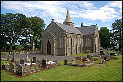
Whitehead is a large seaside village on the east coast of County Antrim, Northern Ireland, lying almost midway between the towns of Carrickfergus and Larne. It lies within the civil parish of Templecorran, the historic barony of Belfast Lower, and is part of Mid and East Antrim Borough Council. Before the Plantation of Ulster its name was recorded as both Whitehead and Kinbaine.
Carincastle or Cairncastle is a small village and civil parish in County Antrim, Northern Ireland near the town of Larne and inland from the village of Ballygally. It had a population of 66 people in the 2001 Census. It is part of the Mid and East Antrim Borough Council area.

Glenarm is a village in County Antrim, Northern Ireland. It lies on the North Channel coast north of the town of Larne and the village of Ballygalley, and south of the village of Carnlough. It is situated in the civil parish of Tickmacrevan and the historic barony of Glenarm Lower. It is part of Mid and East Antrim Borough Council and had a population of 568 people in the 2011 Census. Glenarm takes its name from the glen in which it lies, the southernmost of the nine Glens of Antrim.

Whiteabbey is a townland in Newtownabbey, north of Belfast in County Antrim, Northern Ireland.
James Orr, known as the Bard of Ballycarry, was a poet or rhyming weaver from Ballycarry, Co. Antrim in the province of Ulster in Ireland, who wrote in English and Ulster Scots. His most famous poem was The Irishman. He was the foremost of the Ulster Weaver Poets, and was writing contemporaneously with Robert Burns.

Carnlough is a village in County Antrim, Northern Ireland. It is situated in Mid and East Antrim district, as well the historic barony of Glenarm Lower, and the civil parishes of Ardclinis and Tickmacrevan. It had a population of 1,512 people at the 2011 Census.
Kells is a village near Ballymena in County Antrim, Northern Ireland, that also encompasses the neighbouring village of Connor. As such it is also known as Kells and Connor in which they share a primary school, library, development association etc. It is in Mid and East Antrim District Council. Kells and Connor had a population of 2,053 people in the 2011 Census.
Weaver Poets, Rhyming Weaver Poets and Ulster Weaver Poets were a collective group of poets belonging to an artistic movement who were both influenced by and contemporaries of Robert Burns and the Romantic movement.
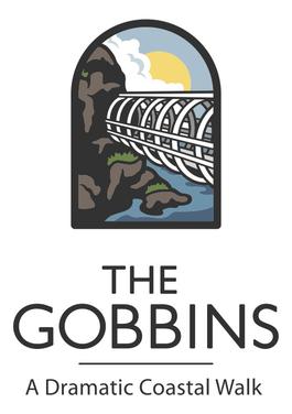
TheGobbins is a cliff-face path at Islandmagee, County Antrim, Northern Ireland, on the Causeway Coastal Route. It runs across bridges, past caves and through a tunnel, along The Gobbins cliffs. The cliffs are recognised for their rich birdlife, important geology and notable species.
Edward Brice or Bryce was a Scottish Presbyterian minister, the first Presbyterian with a living in Ireland.

Berkeley Deane Wise was an Irish civil engineer who made a significant impact on the development of railways and tourism, particularly in Northern Ireland.

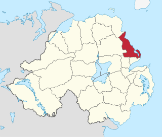
Belfast Lower is a barony in County Antrim, Northern Ireland. To its east lies the east-Antrim coast and Belfast Lough, and it is bordered by four other baronies: Belfast Upper to the south, Carrickfergus to the east, Antrim Upper to the west; Glenarm Upper to the north. The Forth and Milewater rivers both flow through Belfast Lower, with Larne harbour also situated in the barony.
John Bankhead (1738–1833), was an Irish presbyterian minister.