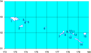
The Rat Islands are a volcanic group of islands in the Aleutian Islands in southwest Alaska, between Buldir Island and the Near Islands group to its west, and Amchitka Pass and the Andreanof Islands group to its east, at about 51°47′17″N178°18′10″E.

Otisstraße is a Berlin U-Bahn station located on the U 6.
Shamrock No. 134 is a rural municipality in the Canadian province of Saskatchewan, located in South-Central Saskatchewan South of the Trans Canada Highway, and includes Kelstern. As of the 2006 Census, the village of Shamrock is a separately governed entity lying within the R.M.'s borders. Shamrock No. 134 is located in SARM Division No. 2.

Nałęcz is a village in the administrative district of Gmina Stolno, within Chełmno County, Kuyavian-Pomeranian Voivodeship, in north-central Poland. It lies 2 kilometres (1 mi) south of Stolno, 9 km (6 mi) south-east of Chełmno, 31 km (19 mi) north of Toruń, and 40 km (25 mi) north-east of Bydgoszcz.
Tauroszyszki, , is a village in the administrative district of Gmina Puńsk, within Sejny County, Podlaskie Voivodeship, in north-eastern Poland, close to the border with Lithuania.
Marynowo-Kolonia is a village in the administrative district of Gmina Sejny, within Sejny County, Podlaskie Voivodeship, in north-eastern Poland, close to the border with Lithuania. It lies approximately 5 kilometres (3 mi) west of Sejny and 110 km (68 mi) north of the regional capital Białystok.
Chrosno is a village in the administrative district of Gmina Łanięta, within Kutno County, Łódź Voivodeship, in central Poland. It lies approximately 6 kilometres (4 mi) south-east of Łanięta, 9 km (6 mi) north-west of Kutno, and 59 km (37 mi) north of the regional capital Łódź.
Muchnice is a village in the administrative district of Gmina Strzelce, within Kutno County, Łódź Voivodeship, in central Poland. It lies approximately 10 kilometres (6 mi) north-east of Kutno and 58 km (36 mi) north of the regional capital Łódź.
Grotniki Duże is a village in the administrative district of Gmina Nowy Korczyn, within Busko County, Świętokrzyskie Voivodeship, in south-central Poland. It lies approximately 1 kilometre (1 mi) north of Nowy Korczyn, 20 km (12 mi) south of Busko-Zdrój, and 66 km (41 mi) south of the regional capital Kielce.
Jasień is a village in the administrative district of Gmina Chmielnik, within Kielce County, Świętokrzyskie Voivodeship, in south-central Poland. It lies approximately 4 kilometres (2 mi) west of Chmielnik and 31 km (19 mi) south of the regional capital Kielce.
Polana is a village in the administrative district of Gmina Czarna, within Bieszczady County, Subcarpathian Voivodeship, in south-eastern Poland, close to the border with Ukraine. It lies approximately 7 kilometres (4 mi) west of Czarna, 15 km (9 mi) south of Ustrzyki Dolne, and 92 km (57 mi) south-east of the regional capital Rzeszów.
Opatkowice is a village in the administrative district of Gmina Kozienice, within Kozienice County, Masovian Voivodeship, in east-central Poland. It lies approximately 5 kilometres (3 mi) northwest of Kozienice and 76 km (47 mi) southeast of Warsaw.
Rokicie is a village in the administrative district of Gmina Brudzeń Duży, within Płock County, Masovian Voivodeship, in east-central Poland. It lies approximately 7 kilometres (4 mi) south-west of Brudzeń Duży, 18 km (11 mi) north-west of Płock, and 114 km (71 mi) north-west of Warsaw.
Porażyn-Dworzec is a village in the administrative district of Gmina Opalenica, within Nowy Tomyśl County, Greater Poland Voivodeship, in west-central Poland. It lies approximately 9 kilometres (6 mi) west of Opalenica, 11 km (7 mi) east of Nowy Tomyśl, and 45 km (28 mi) west of the regional capital Poznań.
Gronów is a village in the administrative district of Gmina Łagów, within Świebodzin County, Lubusz Voivodeship, in western Poland. It lies approximately 4 kilometres (2 mi) south of Łagów, 17 km (11 mi) west of Świebodzin, 43 km (27 mi) north of Zielona Góra, and 48 km (30 mi) south of Gorzów Wielkopolski.
Sławęcin is a village in the administrative district of Gmina Chojnice, within Chojnice County, Pomeranian Voivodeship, in northern Poland. It lies approximately 12 kilometres (7 mi) south of Chojnice and 108 km (67 mi) south-west of the regional capital Gdańsk.
Smołdzino is a village in the administrative district of Gmina Przodkowo, within Kartuzy County, Pomeranian Voivodeship, in northern Poland. It lies approximately 3 kilometres (2 mi) south of Przodkowo, 8 km (5 mi) east of Kartuzy, and 22 km (14 mi) west of the regional capital Gdańsk.
Mielno is a village in the administrative district of Gmina Dębnica Kaszubska, within Słupsk County, Pomeranian Voivodeship, in northern Poland. It lies approximately 9 kilometres (6 mi) south of Dębnica Kaszubska, 19 km (12 mi) south of Słupsk, and 100 km (62 mi) west of the regional capital Gdańsk.
Zielnowo is a village in the administrative district of Gmina Luzino, within Wejherowo County, Pomeranian Voivodeship, in northern Poland. It lies approximately 7 kilometres (4 mi) north-west of Luzino, 14 km (9 mi) west of Wejherowo, and 48 km (30 mi) north-west of the regional capital Gdańsk.
Kolonia Olecko is a settlement in the administrative district of Gmina Olecko, within Olecko County, Warmian-Masurian Voivodeship, in northern Poland.


