Barkers Creek

Last updated
Barkers Creek
Barkers Creek map.png
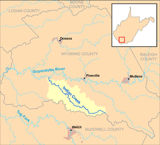
Barkers Creek and its watershed in Wyoming County, West Virginia.
CountryUnited States
StateWest Virginia
County Wyoming
Physical characteristics
Main sourceeastern Wyoming County
3,477 ft (1,060 m) [1]
37°30′52″N81°13′40″W / 37.5145603°N 81.2278771°W / 37.5145603; -81.2278771 [2]
River mouth Guyandotte River
northwest of Tralee
1,381 ft (421 m) [2]
37°33′40″N81°24′30″W / 37.5612252°N 81.4084362°W / 37.5612252; -81.4084362 Coordinates: 37°33′40″N81°24′30″W / 37.5612252°N 81.4084362°W / 37.5612252; -81.4084362 [2]
Length8.0 mi (12.9 km)
Basin features
Basin size36.85 sq mi (95.4 km2)

Barkers Creek is a tributary of the Guyandotte River, 8 miles (13 km) long, [3] in southern West Virginia in the United States. Via the Guyandotte and Ohio rivers, it is part of the watershed of the Mississippi River, draining an area of 36.85 square miles (95.4 km2) in a rural area on the unglaciated portion of the Allegheny Plateau. [4]

Tributary stream or river that flows into a main stem river or lake

A tributary or affluent is a stream or river that flows into a larger stream or main stem river or a lake. A tributary does not flow directly into a sea or ocean. Tributaries and the main stem river drain the surrounding drainage basin of its surface water and groundwater, leading the water out into an ocean.

Guyandotte River river in the United States of America

The Guyandotte River is a tributary of the Ohio River, approximately 166 mi (267 km) long, in southwestern West Virginia in the United States. It was named after the French term for the Wendat Native Americans. It drains an area of the unglaciated Allegheny Plateau south of the Ohio between the watersheds of the Kanawha River to the northeast and Twelvepole Creek and the Big Sandy River to the southwest. Via the Ohio River, it is part of the Mississippi River watershed.

West Virginia State of the United States of America

West Virginia is a state located in the Appalachian region in the Southern United States and is also considered to be a part of the Middle Atlantic States. It is bordered by Pennsylvania to the north, Maryland to the east and northeast, Virginia to the southeast, Kentucky to the southwest, and Ohio to the northwest. West Virginia is the 41st largest state by area, and is ranked 38th in population. The capital and largest city is Charleston.

Barkers Creek's entire course and drainage area are in southeastern Wyoming County. It rises in the eastern extremity of Wyoming County, near the common boundary of Wyoming, Raleigh, and Mercer counties, approximately 3 miles (4.8 km) northeast of Arista, and flows initially westward, then turns northwestward through the unincorporated communities of Bud, Alpoca, and Tralee. It flows into the Guyandotte River from the south, approximately 0.5 miles (0.80 km) northwest of Tralee and 1 mile (1.6 km) southeast of Itmann. In its lower course the creek is paralleled by West Virginia Route 10. [5]

Wyoming County, West Virginia County in the United States

Wyoming County is a county in the U.S. state of West Virginia. As of the 2010 census, the population was 23,796. Its county seat is Pineville. The county was created in 1850 from Logan County and named for the Delaware Indian word meaning "large plains".

Raleigh County, West Virginia County in the United States

Raleigh County is a county located in the U.S. state of West Virginia. As of the 2010 census, the population was 78,859. Its county seat is Beckley. The county was founded in 1850 and is named for Sir Walter Raleigh.

Mercer County, West Virginia County in the United States

Mercer County is a county on the southeastern border of the U.S. state of West Virginia. At the 2010 census, the population was 62,264. Its county seat is Princeton. The county was originally established in the state of Virginia by act of its General Assembly on 17 March 1837, using lands taken from Giles and Tazewell counties.

According to 1992 data from the United States Geological Survey, approximately 94% of the Barkers Creek watershed was forested; approximately 2% was used for agriculture; and approximately 2% was used for commercial or mining purposes. [4]

United States Geological Survey scientific agency of the United States government

The United States Geological Survey is a scientific agency of the United States government. The scientists of the USGS study the landscape of the United States, its natural resources, and the natural hazards that threaten it. The organization has four major science disciplines, concerning biology, geography, geology, and hydrology. The USGS is a fact-finding research organization with no regulatory responsibility.

See also

Related Research Articles

Sandy Creek (Ohio River) creek in Ravenswood, West Virginia

Sandy Creek is a tributary of the Ohio River in western West Virginia in the United States. Via the Ohio River, it is part of the watershed of the Mississippi River, draining an area of 124 square miles (320 km2) on the unglaciated portion of the Allegheny Plateau. The creek is 22 miles (35 km) long, or 38.3 miles (61.6 km) including its Left Fork.

Slab Fork river in the United States of America

The Slab Fork is a tributary of the Guyandotte River, 15.1 miles (24.3 km) long, in southern West Virginia in the United States. Via the Guyandotte and Ohio rivers, it is part of the watershed of the Mississippi River, draining an area of 35.36 square miles (91.6 km2) in a mainly rural area on the unglaciated portion of the Allegheny Plateau.

Cedar Creek (West Virginia) tributary of the Little Kanawha River in central West Virginia in the United States

Cedar Creek is a tributary of the Little Kanawha River, 31.7 miles (51.0 km) long, in central West Virginia in the United States. Via the Little Kanawha and Ohio rivers, it is part of the watershed of the Mississippi River, draining an area of 81 square miles (210 km2) in a rural region on the unglaciated portion of the Allegheny Plateau.

Spring Creek (Little Kanawha River) tributary of the Little Kanawha River in western West Virginia

Spring Creek is a tributary of the Little Kanawha River in western West Virginia in the United States. Via the Little Kanawha and Ohio rivers, it is part of the watershed of the Mississippi River, draining an area of 89 square miles (230 km2) in a rural region on the unglaciated portion of the Allegheny Plateau. It is 25.3 miles (40.7 km) long, or 33.3 miles (53.6 km) long including its Left Fork.

Steer Creek (West Virginia) river in the United States of America

Steer Creek is a tributary of the Little Kanawha River in central West Virginia in the United States. Via the Little Kanawha and Ohio rivers, it is part of the watershed of the Mississippi River, draining an area of 184 square miles (480 km2) in a rural region on the unglaciated portion of the Allegheny Plateau. It is 6.3 miles (10.1 km) long, or 31.7 miles (51.0 km) long including its Right Fork.

Leading Creek (Little Kanawha River tributary) river in the United States of America

Leading Creek is a tributary of the Little Kanawha River, 28.6 miles (46.0 km) long, in central West Virginia in the United States. Via the Little Kanawha and Ohio rivers, it is part of the watershed of the Mississippi River, draining an area of 147 square miles (380 km2) in a rural region on the unglaciated portion of the Allegheny Plateau.

Leading Creek (Tygart Valley River tributary)

Leading Creek is a tributary of the Tygart Valley River, 17.4 miles (28.0 km) long, in eastern West Virginia in the United States. Via the Tygart Valley, Monongahela and Ohio rivers, it is part of the watershed of the Mississippi River, draining an area of 61 square miles (160 km2) in the Allegheny Mountains. The stream's entire course and drainage basin are in northern Randolph County.

Walker Creek (West Virginia) river in the United States of America

Walker Creek is a tributary of the Little Kanawha River, 15.6 miles (25.1 km) long, in western West Virginia in the United States. Via the Little Kanawha and Ohio rivers, it is part of the watershed of the Mississippi River, draining an area of 32 square miles (83 km2) on the unglaciated portion of the Allegheny Plateau.

Buffalo Creek (Monongahela River tributary)

Buffalo Creek is a tributary of the Monongahela River, 30.2 miles (48.6 km) long, in northern West Virginia, in the United States. Via the Monongahela and Ohio rivers, it is part of the watershed of the Mississippi River, draining an area of 125 square miles (320 km2) on the unglaciated portion of the Allegheny Plateau. The stream's entire course and drainage basin are in Marion County.

Buffalo Creek (Guyandotte River tributary)

Buffalo Creek is a tributary of the Guyandotte River, 18.8 miles (30.3 km) long, in southern West Virginia in the United States. Via the Guyandotte and Ohio rivers, it is part of the watershed of the Mississippi River, draining an area of 45 square miles (120 km2) in the Logan Coalfield. The creek was the site of the Buffalo Creek Flood in 1972.

Huff Creek (West Virginia) river in the United States of America

Huff Creek is a tributary of the Guyandotte River, 21.2 miles (34.1 km) long, in southern West Virginia in the United States. Via the Guyandotte and Ohio rivers, it is part of the watershed of the Mississippi River, draining an area of 52 square miles (130 km2) in a rural area on the unglaciated portion of the Allegheny Plateau. The creek was named after Peter Huff, an early settler.

Island Creek (West Virginia) river in the United States of America

Island Creek is a tributary of the Guyandotte River, 18.1 miles (29.1 km) long, in southern West Virginia in the United States. Via the Guyandotte and Ohio rivers, it is part of the watershed of the Mississippi River, draining an area of 105 square miles (270 km2) in a rural area on the unglaciated portion of the Allegheny Plateau, in the Logan Coalfield. Island Creek's entire course and drainage area are in Logan County.

Copperas Mine Fork river in the United States of America

Copperas Mine Fork is a tributary of Island Creek, 9.3 miles (15.0 km) long, in southern West Virginia in the United States. Via Island Creek and the Guyandotte and Ohio rivers, it is part of the watershed of the Mississippi River, draining an area of 45.4 square miles (118 km2) in a rural area on the unglaciated portion of the Allegheny Plateau, in the Logan Coalfield. The Copperas Mine Fork's entire course and drainage area are in Logan County.

Winding Gulf river in the United States of America

Winding Gulf is a 15.5-mile (24.9 km) long tributary of the Guyandotte River in Raleigh County, West Virginia. Winding Gulf is part of the Mississippi River watershed via the Guyandotte and Ohio Rivers, and drains an area of 21.63 square miles (56.0 km2) in a rural area on the Allegheny Plateau.

Indian Creek (Guyandotte River tributary) river in the United States of America

Indian Creek is a tributary of the Guyandotte River, 19.7 miles (31.7 km) long, in southern West Virginia in the United States. Via the Guyandotte and Ohio rivers, it is part of the watershed of the Mississippi River, draining an area of 43 square miles (110 km2) in a rural area on the unglaciated portion of the Allegheny Plateau.

Pinnacle Creek river in the United States of America

Pinnacle Creek is a tributary of the Guyandotte River, 26.6 miles (42.8 km) long, in southern West Virginia in the United States. Via the Guyandotte and Ohio rivers, it is part of the watershed of the Mississippi River, draining an area of 57.23 square miles (148.2 km2) in a rural area on the unglaciated portion of the Allegheny Plateau.

Clear Fork (Guyandotte River tributary) river in the United States of America

The Clear Fork is a tributary of the Guyandotte River, 29 miles (47 km) long, in southern West Virginia in the United States. Via the Guyandotte and Ohio rivers, it is part of the watershed of the Mississippi River, draining an area of 129 square miles (330 km2) in a rural area on the unglaciated portion of the Allegheny Plateau. The Clear Fork flows for its entire length in Wyoming County; its tributary the Laurel Fork also drains a small area of western Raleigh County.

Laurel Fork (Clear Fork Guyandotte River tributary) river in the United States of America

The Laurel Fork is a tributary of the Clear Fork, 23.5 miles (37.8 km) long, in southern West Virginia in the United States. Via the Clear Fork and the Guyandotte and Ohio rivers, it is part of the watershed of the Mississippi River, draining an area of 56.4 square miles (146 km2) in a rural area on the unglaciated portion of the Allegheny Plateau.

Pond Creek (West Virginia) river in the United States of America

Pond Creek is a tributary of the Ohio River, 16 miles (26 km) long, in western West Virginia in the United States. Via the Ohio River, it is part of the watershed of the Mississippi River, draining an area of 43 square miles (110 km2) on the unglaciated portion of the Allegheny Plateau.

References

  1. Google Earth elevation for GNIS source coordinates. Retrieved on 2011-10-20.
  2. 1 2 3 Geographic Names Information System. "Geographic Names Information System entry for Barkers Creek (Feature ID #1535239)" . Retrieved 2011-10-20.
  3. United States Environmental Protection Agency. "Watershed Assessment, Tracking & Environmental Results: Assessment Summary for Reporting Year 2008, West Virginia, Upper Guyandotte Watershed". Archived from the original on 2011-10-15. Retrieved 2011-10-20.
  4. 1 2 Upper Guyandotte Watershed Association (February 2006). "Upper Guyandotte River" (PDF). Archived from the original (PDF) on 2011-10-17. Retrieved 2011-10-20.
  5. West Virginia Atlas & Gazetteer. Yarmouth, Me.: DeLorme. 1997. pp. 58–59. ISBN   0-89933-246-3.