Baruunturuun

Last updated
Baruunturuun District
Баруунтуруун сум
ᠪᠠᠷᠠᠭᠤᠨᠲᠤᠷᠤᠭᠤᠨᠰᠤᠮᠤ
District
Mongolia location map 2.svg
Red pog.svg
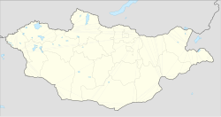
Baruunturuun District
Location in Mongolia
Coordinates: 49°39′30″N94°23′57″E / 49.65833°N 94.39917°E / 49.65833; 94.39917 Coordinates: 49°39′30″N94°23′57″E / 49.65833°N 94.39917°E / 49.65833; 94.39917
Country Mongolia
Elevation [1] 1,232 m (4,045 ft)
Population (2008)
  Total 2,810

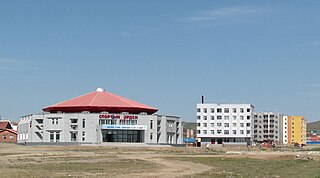
Baruunturuun (Mongolian : Баруунтуруун) is a sum in Uvs Province of Mongolia.

Mongolian language language spoken in Mongolia

The Mongolian languageMoŋɣol kele; in Mongolian Cyrillic: монгол хэл, mongol khel) is the official language of Mongolia and both the most widely-spoken and best-known member of the Mongolic language family. The number of speakers across all its dialects may be 5.2 million, including the vast majority of the residents of Mongolia and many of the Mongolian residents of the Inner Mongolia Autonomous Region. In Mongolia, the Khalkha dialect, written in Cyrillic, is predominant, while in Inner Mongolia, the language is dialectally more diverse and is written in the traditional Mongolian script. In the discussion of grammar to follow, the variety of Mongolian treated is Standard Khalkha Mongolian, but much of what is to be said is also valid for vernacular (spoken) Khalkha and for other Mongolian dialects, especially Chakhar.

Uvs Province Province in Mongolia

Uvs is one of the 21 aimags (provinces) of Mongolia. It is located in the west of the country, 1,336 kilometres or 830 miles away from the national capital Ulaanbaatar. Its capital is Ulaangom which lies 936 metres or 3,070 feet above sea level.

It is the heartland of grain production in the province,[ citation needed ] and lies on the bank of the Turuun River. The sum is also one of the most populous areas in the province. MIAT Mongolian Airlines flew to Baruunturuun directly from Ulan Bator until 2005, but stopped due to a plane shortage. Although the Baruunturuun Airport is not operational at the moment, it is considered the secondary airport of the province.[ citation needed ]

The Turuun River is a river of western Mongolia. It flows through the sum of Baruunturuun in Uvs Province.

MIAT Mongolian Airlines is the Mongolian national airline, headquartered in the MIAT Building in Ulaanbaatar, the capital of Mongolia. The airline operates international scheduled services from its base at Chinggis Khaan International Airport near Ulaanbaatar.

Climate

Baruunturuun has a continental climate (Köppen climate classification Dwb) closely bordering on a subarctic climate (Köppen climate classification Dwc) with warm summers and bitterly cold winters even for Mongolia, owing to very strong altitudinal temperature inversions from drainage of cold air into the western valleys. [2] The average minimum temperature in January is −36.3 °C (−33.3 °F), and temperatures as low as −49.9 °C (−57.8 °F) have been recorded. Temperatures in summer can be hot; the maximum temperature recorded is 39.2 °C (102.6 °F). Much precipitation falls in the summer as rain, with some snow in the spring and autumn. Winters are quite dry, with only light snowfall.

Continental climate

Continental climates often have a significant annual variation in temperature. They tend to occur in the middle latitudes, where prevailing winds blow overland, and temperatures are not moderated by bodies of water such as oceans or seas. Continental climates occur mostly in the Northern Hemisphere, which has the kind of large landmasses required for this type of climate to develop. Most of northern and northeastern China, eastern and southeastern Europe, central and southeastern Canada, and the central and upper eastern United States have this type of climate.

Köppen climate classification widely used climate classification system

The Köppen climate classification is one of the most widely used climate classification systems. It was first published by the Russian climatologist Wladimir Köppen (1846–1940) in 1884, with several later modifications by Köppen, notably in 1918 and 1936. Later, the climatologist Rudolf Geiger introduced some changes to the classification system, which is thus sometimes called the Köppen–Geiger climate classification system.

Subarctic climate

The subarctic climate is a climate characterised by long, usually very cold winters, and short, cool to mild summers. It is found on large landmasses, away from the moderating effects of an ocean, generally at latitudes from 50° to 70°N poleward of the humid continental climates. These climates represent Köppen climate classification Dfc, Dwc, Dsc, Dfd, Dwd and Dsd. In very small areas at high altitudes around the Mediterranean Basin, Iran, Kyrgyzstan, Tajikistan, Turkey, Alaska and other parts of the northwestern United States and Russian South-Eastern regions the climate is classified as Dsc with a dry summer climate, such as in Seneca, Oregon or Atlin, British Columbia.

Climate data for Baruunturuun
MonthJanFebMarAprMayJunJulAugSepOctNovDecYear
Record high °C (°F) 4.9
(40.8)
1.4
(34.5)
12.2
(54)
27.2
(81)
37.5
(99.5)
34.7
(94.5)
39.2
(102.6)
35.0
(95)
33.5
(92.3)
23.9
(75)
13.5
(56.3)
13.0
(55.4)
39.2
(102.6)
Average high °C (°F) −24.7
(−12.5)
−21.8
(−7.2)
−10.4
(13.3)
5.1
(41.2)
17.6
(63.7)
23.0
(73.4)
23.7
(74.7)
22.3
(72.1)
16.6
(61.9)
6.1
(43)
−7.5
(18.5)
−20.8
(−5.4)
2.4
(36.4)
Daily mean °C (°F) −31.4
(−24.5)
−28.3
(−18.9)
−18.4
(−1.1)
−1.6
(29.1)
10.1
(50.2)
15.9
(60.6)
17.1
(62.8)
15.3
(59.5)
8.9
(48)
−0.7
(30.7)
−14.3
(6.3)
−26.6
(−15.9)
−4.5
(23.9)
Average low °C (°F) −36.3
(−33.3)
−35.0
(−31)
−24.7
(−12.5)
−7.5
(18.5)
2.6
(36.7)
8.2
(46.8)
10.9
(51.6)
8.8
(47.8)
2.7
(36.9)
−6.3
(20.7)
−19.9
(−3.8)
−31.5
(−24.7)
−10.7
(12.8)
Record low °C (°F) −49.9
(−57.8)
−45.9
(−50.6)
−40.6
(−41.1)
−30.2
(−22.4)
−12.2
(10)
−8.6
(16.5)
0.0
(32)
−4.8
(23.4)
−12.0
(10.4)
−25.8
(−14.4)
−37.9
(−36.2)
−47.1
(−52.8)
−49.9
(−57.8)
Average precipitation mm (inches) 3.8
(0.15)
3.3
(0.13)
6.0
(0.236)
13.0
(0.512)
16.6
(0.654)
31.6
(1.244)
54.2
(2.134)
43.0
(1.693)
24.5
(0.965)
12.6
(0.496)
9.0
(0.354)
6.3
(0.248)
223.9
(8.816)
Average precipitation days (≥ 1.0 mm) 1.4 1.3 1.9 3.4 2.8 5.8 7.8 7.1 4.1 3.2 2.7 1.9 43.4
Source: NOAA (1961-1990) [3]

Related Research Articles

Choibalsan (city) District in Dornod Province, Mongolia

Choibalsan is the fourth-largest city in Mongolia after Ulaanbaatar, Darkhan, and Erdenet. The name of the city was Bayan Tümen until 1941, when it was renamed after the communist leader Khorloogiin Choibalsan. It is the capital of the province of Dornod. The city administrative unit's official name is Kherlen sum, with area of 281 square kilometres or 108 square miles. It is situated at the Kherlen River, at an elevation of 747 metres or 2,451 feet above sea level.

Ulaangom District in Uvs Province, Mongolia

Ulaangom is the capital of Uvs Province in Mongolia. It is located on the slopes of the Kharkhiraa mountain, 26 kilometres (16 mi) southwest from the lake Uvs Nuur shore and 120 kilometres or 70 miles south from the Russian border.

Humid continental climate Category in the Köppen climate classification system

A humid continental climate is a climatic region defined by Russo-German climatologist Wladimir Köppen in 1900, typified by large seasonal temperature differences, with warm to hot summers and cold winters. Precipitation is usually distributed throughout the year. The definition of this climate regarding temperature is as follows: the mean temperature of the coldest month must be below −3 °C (26.6 °F) and there must be at least four months whose mean temperatures are at or above 10 °C (50 °F). In addition, the location in question must not be semi-arid or arid. The Dfb, Dwb and Dsb subtypes are also known as hemiboreal.

Arvaikheer District in Övörkhangai Province, Mongolia

Arvaikheer, also spelt Arwaiheer – meaning "Barley Steppe" – is the capital of Övörkhangai Aimag (province) and one of the most central points of Mongolia.

Renchinlkhümbe District in Khövsgöl Province, Mongolia

Renchinlkhümbe is a sum of Khövsgöl aimag. The area is about 8,850 square kilometres (3,420 sq mi), of which 2,910 square kilometres (1,120 sq mi) are pasture and 35% are forest. In 2000, the sum had 4284 inhabitants, mainly Darkhad. The sum center, officially named Zöölön, is located 265 kilometres (165 mi) north of Mörön and 998 kilometres (620 mi) from Ulaanbaatar.

Mandalgovi District in Dundgovi Province, Mongolia

Mandalgovi is the capital of the Dundgovi Province of Mongolia, about 300 km south of Ulaanbaatar on the border of the Gobi Desert. It has 10,506 inhabitants (2005), 10,299 (2007). The city administrative unit's official name is Saintsagaan sum.

Bayanbulag District in Bayankhongor, Mongolia

Bayanbulag is a sum (district) of Bayankhongor Province in southern Mongolia.

Ulanhot County-level city in Inner Mongolia, Peoples Republic of China

Ulanhot, formerly known as Wangin Süm, alternatively Wang-un Süme, Ulayanqota in Classical Mongolian, and Wangyehmiao or Wangyemiao in Chinese prior to 1947, is a county-level city and the administrative center of Hinggan League in the East of Inner Mongolia autonomous region. Between the years 1947 and 1950, Ulanhot was the capital of Inner Mongolia Region. In 1950, the capital moved to Zhangjiakou and then again in 1952 it moved to Hohhot, which remains the capital to this day.

Ömnögovi, Uvs District in Uvs Province, Mongolia

Ömnögovi is a sum (district) of Uvs Province in western Mongolia.

Galuut District in Bayankhongor Province, Mongolia

Galuut is a sum (district) of Bayankhongor Province in southern Mongolia.

Khutag-Öndör District in Bulgan Province, Mongolia

Khutag-Öndör is a sum (district) of Bulgan Province in northern Mongolia.

Dashbalbar, Dornod District in Dornod Province, Mongolia

Dashbalbar is a sum (district) of Dornod Province in eastern Mongolia. The population of the sum in 2009 was 3,246, including 1,461 in the sum center. The sum covers 8,713 km² with a population density of 0.37 people/km².

Khalkhgol District in Dornod Province, Mongolia

Khalkhgol is a sum (district) of Dornod Province in eastern Mongolia. There are 3,203 people in the sum, including 1,756 in the sum center. The area of the sum is 28,093 km², with a population density of 0.11 people/km².The largest district in Mongolia by land area.

Bayan-Ovoo, Khentii District in Khentii Province

Bayan-Ovoo is a sum (district) of Khentii Province in eastern Mongolia. The sum had a population in 2008 of 1,581 and an area of 3,381 km².

Tsogt-Ovoo, Ömnögovi District in Ömnögovi Province, Mongolia

Tsogt-Ovoo is a sum (district) of Ömnögovi Province in southern Mongolia. As of 2009 the population of the sum was 1,666, including 619 in the sum center. The area of the sum is 6,526 square kilometres (2,520 sq mi) and its population density is 0.26 people/km².

Khujirt District in Övörkhangai Province, Mongolia

Khujirt is a sum (district) of Övörkhangai Province in central Mongolia. The total population of the sum in 2008 was 6,649.

Bayandelger, Sükhbaatar District in Mongolia

Bayandelger is a sum (district) of Sükhbaatar Province in eastern Mongolia. The population of the sum is 4,569 including 1,169 in the sum center.

Tosontsengel, Zavkhan District in Zavkhan Province, Mongolia

Tosontsengel is a sum of Zavkhan Province (aimag) in western Mongolia. It is the largest sum and sum centre in Zavkhan aimag after its capital.

Bayangol, Selenge District in Mongolia

Bayangol is a sum (district) of Selenge Province in northern Mongolia. The capital town of the district is officially named Baruunkharaa.

References

  1. "Baruunturuun, Mongolia". Falling Rain Global Gazetteer. Retrieved 27 January 2013.
  2. Bayasgalan Gerelchuluun and Ahn Joong-Bae; ‘Air temperature distribution over Mongolia using dynamical downscaling and statistical correction’, International Journal of Climatology; 34:2464-2476 (2014)
  3. "Baruuhturuun Climate Normals 1961-1990". National Oceanic and Atmospheric Administration . Retrieved January 12, 2012.