
Citizens of Mauritania have various transportation methods. Railways and highways connect major cities in the country. Mauritania is a coastal country so there are many ports along its coast and there are a few big rivers that run through the country. Lastly, there are 26 airports spread out throughout the country.

Nouakchott is the capital and largest city of Mauritania. It is one of the largest cities in the Sahara. The city also serves as the administrative and economic center of Mauritania.
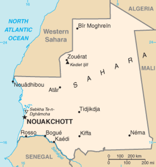
Mauritania, a country in the western region of the continent of Africa, is generally flat, its 1,030,700 square kilometres forming vast, arid plains broken by occasional ridges and clifflike outcroppings. Mauritania is the world’s largest country lying entirely below an altitude of 1,000 metres (3,300 ft). It borders the North Atlantic Ocean, between Senegal and Western Sahara, Mali and Algeria. It is considered part of both the Sahel and the Maghreb. A series of scarps face southwest, longitudinally bisecting these plains in the center of the country. The scarps also separate a series of sandstone plateaus, the highest of which is the Adrar Plateau, reaching an elevation of 500 metres or 1,640 feet. Spring-fed oases lie at the foot of some of the scarps. Isolated peaks, often rich in minerals, rise above the plateaus; the smaller peaks are called Guelbs and the larger ones Kedias. The concentric Guelb er Richat is a prominent feature of the north-central region. Kediet ej Jill, near the city of Zouîrât, has an elevation of 915 metres or 3,002 feet and is the highest peak.

Mali is a landlocked nation in West Africa, located southwest of Algeria, extending south-west from the southern Sahara Desert through the Sahel to the Sudanian savanna zone. Mali's size is 1,240,192 square kilometers.
A monolith is a geological feature consisting of a single massive stone or rock, such as some mountains. For instance, Savandurga mountain is a monolith mountain in India. Erosion usually exposes the geological formations, which are often made of very hard and solid igneous or metamorphic rock. Some monoliths are volcanic plugs, solidified lava filling the vent of an extinct volcano.

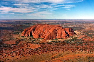
The Sahara is a desert on the African continent. With an area of 9,200,000 square kilometres (3,600,000 sq mi), it is the largest hot desert in the world and the third-largest desert overall, smaller only than the deserts of Antarctica and the northern Arctic.

A 2-8-8-4 steam locomotive, under the Whyte notation, has two leading wheels, two sets of eight driving wheels, and a four-wheel trailing truck. The type was generally named the Yellowstone, a name given it by the first owner, the Northern Pacific Railway, whose lines ran near Yellowstone National Park. Seventy-two Yellowstone-type locomotives were built for four U.S. railroads.

Nouadhibou is the second largest city in Mauritania and serves as a major commercial centre. The city itself has about 118,000 inhabitants expanding to over 140,000 in the larger metropolitan area. It is situated on a 65-kilometre peninsula or headland called Ras Nouadhibou, Cap Blanc, or Cabo Blanco, of which the western side has the Moroccan city of La Güera. Nouadhibou is consequently located merely a couple of kilometres from the border between Mauritania and Morocco. Its current mayor is Elghassem Ould Bellali, who was installed on 15 October 2018.


Twenty-mule teams were teams of eighteen mules and two horses attached to large wagons that transported borax out of Death Valley from 1883 to 1889. They traveled from mines across the Mojave Desert to the nearest railroad spur, 165 miles (266 km) away in Mojave. The routes were from the Harmony and Amargosa Borax Works to Daggett, California, and later Mojave, California. After Harmony and Amargosa shut down in 1888, the mule team's route was moved to the mines at Borate, 3 miles (5 km) east of Calico, back to Daggett. There they worked from 1891 until 1898 when they were replaced by the Borate and Daggett Railroad.

Sahara with Michael Palin is a four-part BBC television series presented by British comedian and travel presenter Michael Palin, and first broadcast in 2002. In it, Palin travelled around the Sahara in Northern and Western Africa, meeting people and visiting places. The journey route included the following countries and territories: Gibraltar, Morocco, Western Sahara, Mauritania, Senegal, Mali, Niger, Libya, Tunisia, Algeria and Ceuta, Spain.
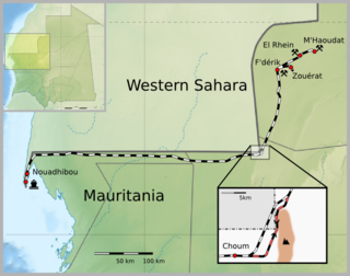
The Mauritania Railway is the national railway of Mauritania. Construction of the line began in 1960, with it opening in 1963. It consists of a single, 704-kilometre (437 mi) railway line linking the iron mining centre of Zouérat with the port of Nouadhibou, via Fderik and Choum. The state agency Société nationale industrielle et minière (SNIM) controls the railway line.

A train driver, engine driver, engineman or locomotive driver, commonly known as an engineer or railroad engineer in the United States and Canada, and also as a locomotive handler, locomotive engineer, locomotive operator, train operator, or motorman, is a person who operates a train, railcar, or other rail transport vehicle. The driver is in charge of and is responsible for the mechanical operation of the train, train speed, and all of the train handling. In American English, a hostler moves engines around rail yards, but does not take them out on the main line tracks; the British English equivalent is a shunter.

The length of a train may be measured in number of wagons or in metres for general freight. Train lengths and loads on electrified railways, especially lower voltage 3000 V DC and 1500 V DC, are limited by traction and power considerations. Drawgear and couplings can also be a limiting factor, along with curves, gradients and crossing loop lengths.

The Sishen–Saldanha railway line, also known as the Ore Export Line (OREX), is an 861-kilometre-long (535 mi) heavy-haul railway line in South Africa. It connects iron ore mines near Sishen in the Northern Cape with the port at Saldanha Bay in the Western Cape. It is used primarily to transport iron ore (60 million tonnes per year) and does not carry passenger traffic.

The Silver Star Cafe is a restaurant located in the west end of Port Hedland, Western Australia. Its kitchen and lounge area are housed within a historic preserved railway carriage, and it has an alfresco deck alongside.
Orion is a steel roller coaster located at Kings Island amusement park in Mason, Ohio. Manufactured by Bolliger & Mabillard, Orion became the seventh giga coaster in the world when it opened to the public on July 2, 2020. It is the largest investment in Kings Island's history, costing an estimated $30 million. The coaster stands 287 feet (87 m), features a 300-foot drop (91 m), and reaches a maximum speed of 91 mph (146 km/h). It is situated in the Area 72 section of the park on a site formerly occupied by Firehawk.
The Ujevwu–Itakpe Railway is a standard gauge railway in Nigeria that connects the port city of Warri to the inland town of Itakpe. Construction began in 1987 on an industrial railway to supply the Ajaokuta Steel Mill with iron ore and coal. After a protracted construction period of more than 30 years, the railway was finally inaugurated in 2020 as a mixed freight and passenger line. Construction is underway on an extension to Abuja, where it will connect to the Lagos–Kano Standard Gauge Railway.
