The Meuse or Maas is a major European river, rising in France and flowing through Belgium and the Netherlands before draining into the North Sea from the Rhine–Meuse–Scheldt delta. It has a total length of 925 km.

The Rhine is one of the major European rivers. The river begins in the Swiss canton of Graubünden in the southeastern Swiss Alps, forms part of the Swiss-Liechtenstein, Swiss-Austrian, Swiss-German and then the Franco-German border, then flows in a mostly northerly direction through the German Rhineland and the Netherlands and eventually empties into the North Sea.

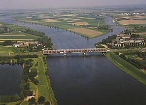
The Waal is the main distributary branch of the river Rhine flowing approximately 80 km (50 mi) through the Netherlands. It is the major waterway connecting the port of Rotterdam to Germany. Before it reaches Rotterdam, it joins with the Afgedamde Maas near Woudrichem to form the Boven Merwede. Along its length, Nijmegen, Tiel, Zaltbommel and Gorinchem are towns of importance with direct access to the river.

Hollands Diep is a wide river in the Netherlands and an estuary of the Rhine and Meuse rivers. Through the Scheldt-Rhine Canal it connects to the Scheldt river and Antwerp.

The Afgedamde Maas is a former distributary of the Maas River in the Dutch provinces of North Brabant and Gelderland. The Maas splits near Heusden with one channel flowing north until its confluence with the river Waal to form the Merwede, while the other channel continues west as the main distributary of the Maas.
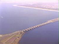
The Haringvliet is a large inlet of the North Sea, in the province of South Holland in the Netherlands. It is an important estuary of the Rhine-Meuse delta.
The Nieuwe Merwede is a Dutch canal, mainly fed by the river Rhine, that was constructed in 1870 to form a branch in the Rhine–Meuse delta. It was dug along the general trajectories of a number of minor Biesbosch creeks to reduce the risk of flooding by diverting the water away from the Beneden Merwede, and to facilitate navigation and regulate river traffic in the increasingly silted-up delta.

The Amer is a river in the Dutch province of North Brabant. It is a continuation of the Bergse Maas river from the river Donge near Raamsdonksveer to the point where it joins the river Nieuwe Merwede to form the Hollands Diep estuary, and has a total length of approximately 20 kilometres (12 mi). The Amer is a major navigation route. It forms the south boundary of the Biesbosch National Park.

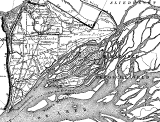
De Biesbosch National Park is one of the largest national parks of the Netherlands and one of the last extensive areas of freshwater tidal wetlands in Northwestern Europe. The Biesbosch consists of a large network of rivers and smaller and larger creeks with islands. The vegetation is mostly willow forests, although wet grasslands and fields of reed are common as well. The Biesbosch is an important wetland area for waterfowl and has a rich flora and fauna. It is especially important for migrating geese.
The Land of Altena is a historical region and former fiefdom of the Lords of Altena, historically part of the County of Holland, but since 1815 located in the Dutch province of North Brabant.
The Merwede is the name of several connected stretches of river in the Netherlands, between the cities of Woudrichem, Dordrecht and Papendrecht. The river is part of the Rhine–Meuse–Scheldt delta and is mostly fed by the river Rhine.
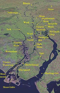
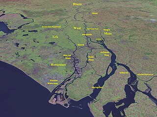
The Rhine–Meuse–Scheldt delta is a river delta in the Netherlands formed by the confluence of the Rhine, the Meuse and the Scheldt rivers. In some cases, the Scheldt delta is considered a separate delta to the Rhine-Meuse delta. The result is a multitude of islands, branches and branch names that may at first sight look bewildering, especially as a waterway that appears to be one continuous stream may change names as many as seven times, e.g. Rhine → Bijlands Kanaal → Pannerdens Kanaal → Nederrijn → Lek → Nieuwe Maas → Het Scheur → Nieuwe Waterweg. Since the Rhine contributes most of the water, the shorter term Rhine Delta is commonly used. However, this name is also used for the delta where the Alpine Rhine flows into Lake Constance, so it is clearer to call the larger one Rhine–Meuse delta, or even Rhine–Meuse–Scheldt delta, as the Scheldt ends in the same delta. By some calculations, the delta covers 25,347 km2 (9,787 sq mi), making it the largest in Europe.

The Noord ("North") is a short tidal river in the western Netherlands, in the province of South Holland.

The Oude Maas is a distributary of the Rhine River, and a former distributary of the Maas River, in the Dutch province of South Holland. It begins at the city of Dordrecht where the Beneden Merwede river splits into the Noord River and the Oude Maas. It ends when it joins the Nieuwe Maas to form Het Scheur.

The Nieuwe Maas is a distributary of the Rhine River, and a former distributary of the Maas River, in the Dutch province of South Holland. It runs from the confluence of the rivers Noord and Lek, and flows west through Rotterdam. It ends west of the city where it meets the Oude Maas, near Vlaardingen, to form Het Scheur. After a few miles, the Scheur continues as the artificial Nieuwe Waterweg. The total length of the Nieuwe Maas is approximately 24 kilometres (15 mi).

The Oude Maasje is a former distributary of the river Maas, which runs parallel to the current canalised Bergse Maas.
The Heusden Canal is a canal on the border of the Dutch provinces North Brabant and Gelderland, roughly between Wijk en Aalburg and Heusden. The canal connects the Afgedamde Maas and Bergse Maas and has a total length of approximately 2.3 km. The canal used to connect the city of Heusden to the main branch of the river Meuse. Later on, the original main branch was closed off and the river received a new, artificial mouth: the Bergse Maas. After that, the Heusden Canal was improved to maintain a shipping connection between the two Meuse branches.
The Land of Heusden and Altena is a region located in the Dutch province of North Brabant. In 1904 it consisted of the historical regions Land van Altena and Land van Heusden. Historically this region has been a part of North Brabant since 1815. During the Dutch Republic it belonged to Holland. It resembles comparable landscapes in the latter one, like e.g. the Alblasserwaard, which is situated just north of the region.

The Drongelens Canal is a drainage canal that runs from 's-Hertogenbosch to Drongelen in North Brabant. The colloquial Dutch name, and the name used on street signs is Drongelens Kanaal. The official Dutch name is Afwateringskanaal van 's-Hertogenbosch naar Drongelen.