Hornsby is a suburb on the Upper North Shore of Sydney in the state of New South Wales, Australia, approximately 23 kilometres (14 mi) north-west of the Sydney central business district. It is the administrative centre of the local government area of Hornsby Shire.

Carlingford is a suburb of Sydney, in the state of New South Wales, Australia. Carlingford is 22 kilometres north-west of the Sydney central business district in the local government area of City of Parramatta. Carlingford sits at the meeting point of Northern Sydney and Western Sydney sitting on both sides of Pennant Hills Road which generally acts as a divider of the two regions. While being part of City of Parramatta, it is sometimes referred to as being part of the Hills District.

Turramurra is a suburb on the Upper North Shore of Sydney, in the state of New South Wales, Australia. It is located 16 kilometres (10 mi) north-west of the Sydney central business district, in the local government area of Ku-ring-gai Council. It shares the postcode of 2074 with the adjacent suburbs of North Turramurra, South Turramurra and Warrawee.

Brooklyn is a suburb and the northern most town on the Pacific Highway in Sydney, New South Wales, Australia. Brooklyn is located on the northern outskirts of Sydney and is located in the local government area of the Hornsby Shire with a population of 722 as of the 2016 census. Brooklyn is surrounded by the Muogamarra Nature Reserve and occupies a strip of waterfront along the southern bank of the Hawkesbury River.

Normanhurst is a suburb in the Upper North Shore region of Sydney in the state of New South Wales, Australia, 22 kilometres north-west of the Sydney central business district in the local government area of Hornsby Shire.

Mount Colah is an outer suburb of Northern Sydney, in the state of New South Wales, Australia 24 kilometres north of the Sydney central business district, in the local government area of Hornsby Shire.

Mount Colah railway station is located on the Main Northern line, serving the Mount Colah suburb of Sydney, Australia. It is served by Sydney Trains T1 North Shore Line services and some early morning and late night NSW TrainLink Central Coast & Newcastle Line services.
Mount Kuring-gai railway station is on the Main Northern Line, serving the Sydney suburb of Mount Kuring-gai. It is served by Sydney Trains T1 North Shore Line services and some early morning and late night NSW TrainLink Central Coast & Newcastle Line services.

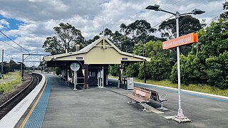
Cowan railway station is a railway station located on the Main Northern line on the northern fringes of Sydney, New South Wales, Australia. It serves the suburb of Cowan, and the station was opened in 1890.

Mount Kuring-gai is an outer suburb of Northern Sydney, in the state of New South Wales, Australia. Mount Kuring-gai is located 31 kilometres north-west of the Sydney central business district, in the local government area of Hornsby Shire.

Engadine is a suburb in southern Sydney, in the state of New South Wales, Australia. Engadine is located 33 kilometres (21 mi) south of the Sydney central business district, in the local government area of the Sutherland Shire.
Berowra Heights is an outer suburb of Northern Sydney, in the state of New South Wales, Australia 39 kilometres north of the Sydney central business district, in the local government area of Hornsby Shire. Berowra Heights is north-west of the suburb of Berowra and east of Berowra Waters.

Berowra Waters is an outer suburb of Northern Sydney, in the state of New South Wales, Australia. Berowra is located 40 kilometres north of the Sydney central business district, in the local government area of Hornsby Shire. Berowra Waters is north-west of the suburbs of Berowra Heights and west of Berowra.

Cowan is a small outer suburb of Sydney, in the state of New South Wales, Australia, approximately 40 kilometres (25 mi) north of the Sydney central business district, in the local government area of Hornsby Shire. Cowan shares the postcode of 2081 with Berowra. Brooklyn, which lies 6 kilometres (3.7 mi) to the north-east of Cowan, is considered the northernmost suburb of the Greater Sydney Metropolitan Area.

M1 Pacific Motorway is a 127-kilometre motorway linking Sydney to Newcastle via the Central Coast and Hunter regions of New South Wales. Formerly known but still commonly referred to by both the public and the government as the F3 Freeway, Sydney–Newcastle Freeway, and Sydney–Newcastle Expressway, it is part of the AusLink road corridor between Sydney and Brisbane.

Hornsby Heights is a suburb of Northern Sydney, in the state of New South Wales, Australia. Hornsby Heights is located 26 kilometres north-west of the Sydney central business district, in the local government area of Hornsby Shire. The suburb is often referred to as part of the Upper North Shore.
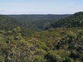
The Berowra Creek, a watercourse that is part of the Hawkesbury-Nepean catchment, is located to the north of the Sydney central business district in the Hornsby Shire of New South Wales, Australia.

Transport in Sydney is provided by an extensive network of public transport operating modes including metro, train, bus, ferry and light rail, as well as an expansive network of roadways, cycleways and airports. According to the 2006 census, in terms of travel to work or study Sydney has the highest rate of public transport usage among the Australian capital cities of 26.3% with more than 80% of weekday trips to/from Central Sydney being made by public transport. According to the New South Wales State Plan, the state has Australia's largest public transport system. The public transport network is regulated by Transport for NSW.

The Mooney Mooney Bridge, officially the Mooney Mooney Creek Bridge, and popularly known as The NSW Big Dipper Bridge, is a twin cantilever bridge that carries the Pacific Motorway (M1) across Mooney Mooney Creek, located near Mooney Mooney in the Brisbane Water National Park on the Central Coast of New South Wales, Australia. The concrete box girder bridge was opened on 14 December 1986 by the Prime Minister of Australia, Bob Hawke, and is owned and maintained by Transport for NSW, an agency of the Government of New South Wales.

Northern Sydney is a large metropolitan area in Greater Sydney, New South Wales, Australia on the north shore of Sydney Harbour and Parramatta River. The region embraces suburbs in Sydney's north-east, north and inner north west. Northern Sydney is divided into distinctive regions such as the North Shore, Northern Beaches and Forest District.