The Birmingham District is a geological area in the vicinity of Birmingham, Alabama, where the raw materials for making steel, limestone, iron ore, and coal are found together in abundance. The district includes Red Mountain, Jones Valley, and the Warrior and Cahaba coal fields in Central Alabama.

West Overton is located approximately 40 miles (64 km) southeast of Pittsburgh, in East Huntingdon Township, Westmoreland County, Pennsylvania, United States. It is on PA 819 between the towns of Mount Pleasant and Scottdale. Its latitude is 40.117N and its longitude is -79.564W.

The Nuttallburg Coal Mining Complex and Town Historic District is located near Winona, West Virginia in New River Gorge National Park and Preserve. The townsite is almost directly across from the Kay Moor mine and townsite, now abandoned. Like Kay Moor, the town is built around the railroad line at the bottom of the gorge, with an array of coke ovens and mining structures, as well as a bridge across the New River to South Nuttall.
Wheeling Island Historic District is a national historic district located on Wheeling Island in Wheeling, Ohio County, West Virginia. The district includes 1,110 contributing buildings, 5 contributing sites, 2 contributing structures, and 3 contributing objects. It is a largely residential district consisting of two-story, frame detached dwellings built in the mid- to late-19th and early-20th century, including the Irwin-Brues House (1853) and a number of houses on Zane Street. The houses are representative of a number of popular architectural styles including Bungalow, Italianate, Queen Anne, and Colonial Revival. Notable non-residential contributing properties include the Exposition Building (1924), Thompson United Methodist Church (1913-1915), Madison School (1916), firehouse (1930-1931), the Bridgeport Bridge (1893), the Aetnaville Bridge (1891), "The Marina," Wheeling Island Baseball Park, and "Belle Island Park." It includes the separately listed Wheeling Suspension Bridge, Harry C. and Jessie F. Franzheim House, and John McLure House.

Etna Furnace, also known as Mount Etna Furnace, Aetna Furnace, and Aetna Iron Works, is a historic iron furnace complex and national historic district located at Catharine Township, Blair County, Pennsylvania. The district includes five contributing buildings, six contributing sites, and two contributing structures. It encompasses a community developed around an iron furnace starting in 1805. Included in the district is the four-sided stone furnace (1808), gristmill site, canal locks, site of lock keeper's house, aqueduct, two small houses, the ruins of a charcoal house (1808), the foundation of a tally house, a blacksmith shop, bank barn, foundation of a boarding house, three family tenant house, two iron master' mansions, a store and paymaster's office, Methodist / Episcopal Church (1860), and cemetery with graves dating between 1832 and 1859.

Huntingdon Furnace is a national historic district and historic iron furnace and associated buildings located at Franklin Township in Huntingdon County, Pennsylvania. It consists of seven contributing buildings and one contributing structure. They are the iron furnace, office building, the ironmaster's mansion, log worker's house, a residence, the farm manager's residence, the grist mill and the miller's house. The iron furnace was moved to this site in 1805, from its original site one mile upstream. It measures 30 feet square by 30 feet high. The ironmaster's mansion was built in 1851, and is a 2 1/2-story, "L"-shaped frame dwelling. The grist mill dates to 1808, and is a 3 1/2-story, rubble stone building measuring 50 feet by 45 feet. The furnace was in operation from 1796, until it ceased operations in the 1880s.

The Huntingdon Borough Historic District is a national historic district which is located in Huntingdon in Huntingdon County, Pennsylvania.

Colver Historic District is a national historic district located at Barr Township and Cambria Township in Cambria County, Pennsylvania. The district includes 336 contributing buildings, 5 contributing sites, and 3 contributing structures. The district consists of residential areas, coal mining resources, Cambria and Indiana Railroad shop buildings, and a dairy farm associated with the Ebensburg Coal Company's mine and developed between 1911 and 1943. Notable buildings include a variety of brick and frame workers' housing, the Ebensburg Coal Company office building (1914), stone company store (1912), Colver Amusement Company (1912), Colver Hotel (1912), Colver Presbyterian Church (1915), public school (1927), hospital (1914), Roundhouse No. 1 (1918), Roundhouse No. 2 (1920), and main power building (1911).

The Revloc Historic District is a national historic district located at Cambria Township in Cambria County, Pennsylvania.

Downtown Johnstown Historic District is a national historic district located at Johnstown in Cambria County, Pennsylvania. The district includes 109 contributing buildings, 4 contributing sites, and 1 contributing structure in the central business district and surrounding residential areas of Johnstown. The district includes some buildings dated before the Johnstown Flood, but the majority date from 1890 to 1930. Notable buildings include the Alma Hall (1884), Bantley Building (1888), Stenger Dry Goods Store (1883), Widmann Building (1892), Cambria Iron Office Building, St. Vincent DePaul Building, Swank Building (1907), Glosser Brothers Department Store (1905), Johnstown City Hall (1900), former U.S. Post Office (1912), State Theater (1926), U.S. Post Office (1938), Franklin Street United Methodist Church (1869), St. John Gualbert Cathedral (1896), First United Methodist Church (1911), Elks Building (1903), and Moose Building (1917). Located in the district and listed separately are the Cambria Public Library Building, G.A.R. Hall, and Nathan's Department Store.

Windber Historic District is a national historic district located at Paint Borough, Scalp Level, and Windber in Cambria County and Somerset County, Pennsylvania. The district includes 944 contributing buildings and 1 contributing site. It encompasses an area first developed by the Berwind-White Coal Company in 1897, and developed and between 1897 and 1930. It includes the central business district of Windber and surrounding residential areas, consisting largely of workers' housing. Notable buildings include the Berwind-White Headquarters Building (1903), Eureka Department Store (1899), Windber Trust Company (1910), Windber Electric Building (1925), Clement Building (1902), Windber Hotel (1902), former train station (1916), Arcadia Theater (1919), Clubhouse (1899), David Shaffer House, and Windber Hospital.
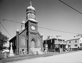
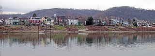
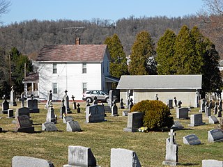
Boswell Historic District is a national historic district located at Boswell in Somerset County, Pennsylvania. The district includes 90 contributing buildings and 1 contributing site. It encompasses an area developed by the Merchant's Mining Company of Baltimore, Maryland starting in 1901. It includes the remaining extant mine resources and the archaeological remains of the mine. They consist of utilitarian industrial buildings, four types of vernacular housing, and a variety of commercial, social, and institutional buildings. Notable buildings include the First National Bank of Boswell (1919), Merchant's Coal Company office (1901), St. Stanislaus Roman Catholic Church (1918), and Sts. Peter and Paul Russian Orthodox Church (1918).

Cairnbrook Historic District is a national historic district located at Shade Township in Somerset County, Pennsylvania. The district includes 132 contributing buildings and 8 contributing structures. It encompasses an area developed by the Loyalhanna Coal and Coke Company of Philadelphia, Pennsylvania between 1912 and 1920. It includes the remaining extant mine resources and the archaeological remains of the mine. They consist of workers' housing, a variety of commercial and social buildings, and a modern draft entry mine with accompanying extractive buildings and structures. Notable buildings include the motor barn, supply house, electric substation, and Loyalhanna Coal and Coke Company Office (1914). The mine operated until 1958.

Shade Furnace Archeological District, also known as Old Shade Furnace and Shade Forge, is a national historic district located at Shade Township in Somerset County, Pennsylvania. The district includes four contributing sites and two contributing objects. It encompasses the ruins of a countryside plantation style iron forge operation that operated from 1808 to 1858. It includes a stone blast furnace structure, a forge site, an ore pit site, a farmstead site, and a late 19th-century coal mine complex. The area includes a number of archaeological sites associated with the ruins of abandoned buildings.

Delaware, Lackawanna and Western Railroad Yard-Dickson Manufacturing Co. Site is a national historic district located in Scranton, Lackawanna County, Pennsylvania. It encompasses the Steamtown National Historic Site and Scranton Army Ammunition Plant and includes 16 contributing buildings, four contributing sites, and five contributing structures. The yard includes buildings and structures related to the yard's expansion in 1899-1939, and its usage as steam locomotive maintenance complex. The Dickson Manufacturing Company built steam locomotives, and the site of its works are included in this district.

The Star Junction Historic District is a national historic district that is located in Perry Township, Fayette County, Pennsylvania.
The Smock Historic District is a national historic district that is located in Franklin Township and Menallen Township, Fayette County, Pennsylvania.

The New Kensington Production Works Historic District, also known as the New Kensington Works and Arnold Works, is a national historic district that is located in New Kensington, Westmoreland County, Pennsylvania.

The Slickville Historic District is a national historic district that is located in Salem Township, Westmoreland County, Pennsylvania.

The Smith Mine Historic District, in Carbon County, Montana, near Bearcreek, Montana, is a historic district which was listed on the National Register of Historic Places in 2009. The district included 27 contributing buildings and 12 contributing structures on 200 acres (81 ha).


