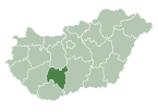
Tolna is an administrative county in present Hungary as it was of the former Kingdom of Hungary. It lies in central Hungary, on the west bank of the river Danube. It shares borders with the Hungarian counties Somogy, Fejér, Bács-Kiskun, and Baranya. The capital of Tolna county is Szekszárd. Its area is 3703 km².
Mohra Sharif is a spiritual center and home of the Sufi order is a Naqshbandi in origin, and is based in a small village called Mohra Sharif located in the Murree Hills of Punjab, near the Pakistani capital of Islamabad. It was made into a spiritual center by Baba Ji Khawaja Muhammad Qasim Sadiq, a purported Sufi shaikh of this area.
Islam Pura is one of the neighbourhoods of Saddar Town in Karachi, Sindh, Pakistan.
Zavety Ilyicha is the name of several inhabited localities in Russia.
Fuentelespino de Haro is a municipality in Cuenca, Castile-La Mancha, Spain. It has a population of 311.

Bikač is a settlement (hamlet) in the Kikinda municipality, Republic of Serbia. Officially, Bikač is not classified as a separate settlement, but as a part of the village of Bašaid.
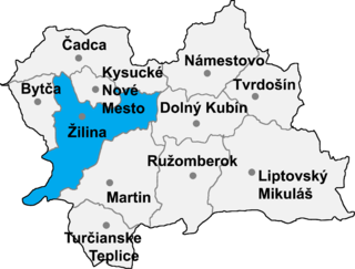
Ďurčiná is a village and municipality in Žilina District in the Žilina Region of northern Slovakia.

Tabdi is a village and municipality in Bács-Kiskun county, in the Southern Great Plain region of southern Hungary.

Nagyszénás is a large village in Békés County, in the Southern Great Plain region of south-east Hungary.

Hajdúhadház is a town in Hajdú-Bihar county, in the Northern Great Plain region of eastern Hungary.

Zavala District is a district of Inhambane Province in south-east Mozambique. Its principal town is Zavala. The district is located at the east of the province, and borders with Inharrime District in the north and with Manjacaze District of Gaza Province in the west. In the east and in the south, the district is bounded by the Indian Ocean. The area of the district is 1,997 square kilometres (771 sq mi). It has a population of 139.616 as of 2007.

Pogăceaua is a commune in Mureș County, Romania composed of ten villages: Bologaia (Balogéja), Ciulea (Csulja), Deleni (Ökröstó), Fântâna Babii, Pârâu Crucii, Pogăceaua, Scurta, Sicele, Valea Sânpetrului and Văleni.

Adekar is a town and municipality (baladiyah) in northern Algeria. It contains the settlements of Adekar, Ali-Thoum, Tizi Lqarne, Djebla, Kebouche, Tizi Ougueni, Ighil Laqrun, Timri Mahmoud, Mechnouh, Ikhetaben, Halafa, Thighzert, Thimri Mahmoud, Thazrut, Hanguedh, Ait Malek, Hriz, Kiria, Ait Yahia Youcef, Aoughled, Ait maamar, Ait yidir, Aguemoun,I ksilen, Ighzer Abas, Thakamra.

Gruszowa is a village in the administrative district of Gmina Fredropol, within Przemyśl County, Subcarpathian Voivodeship, in south-eastern Poland, close to the border with Ukraine. It lies approximately 7 kilometres (4 mi) south-west of Fredropol, 15 km (9 mi) south-west of Przemyśl, and 64 km (40 mi) south-east of the regional capital Rzeszów.
Wólka Szczawińska is a village in the administrative district of Gmina Nowe Miasto, within Płońsk County, Masovian Voivodeship, in east-central Poland. It lies approximately 21 kilometres (13 mi) east of Płońsk and 55 km (34 mi) north-west of Warsaw.
Udrzynek is a village in the administrative district of Gmina Brańszczyk, within Wyszków County, Masovian Voivodeship, in east-central Poland. It lies approximately 7 kilometres (4 mi) north-east of Brańszczyk, 18 km (11 mi) north-east of Wyszków, and 69 km (43 mi) north-east of Warsaw.

Adekar District is a district of Béjaïa Province, Algeria.

Kudina is a village in Jõgeva Parish, Jõgeva County in eastern Estonia.
Baixo Longa is a city and commune of Angola, located in the province of Cuando Cubango.