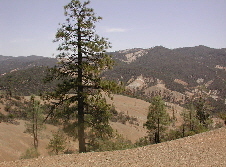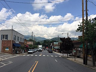
Black Mountain is a town in Buncombe County, North Carolina, United States. The population was 7,848 at the 2010 census. It is part of the Asheville Metropolitan Statistical Area. The town is named for the old train stop at the Black Mountain Depot and is located at the southern end of the Black Mountain range of the Blue Ridge Mountains in the Southern Appalachians.

The Great Basin is the largest area of contiguous endorheic watersheds in North America. It spans nearly all of Nevada, much of Oregon and Utah, and portions of California, Idaho, and Wyoming. It is noted for both its arid climate and the basin and range topography that varies from the North American low point at Badwater Basin to the highest point of the contiguous United States, less than 100 miles (160 km) away at the summit of Mount Whitney. The region spans several physiographic divisions, biomes, ecoregions, and deserts.
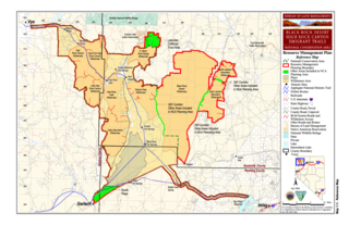
The Black Rock Desert is a semi-arid region (in the Great Basin shrub steppe eco-region), of lava beds and playa, or alkali flats, situated in the Black Rock Desert–High Rock Canyon Emigrant Trails National Conservation Area, a silt playa 100 miles (160 km) north of Reno, Nevada that encompasses more than 300,000 acres (120,000 ha) of land and contains more than 120 miles (200 km) of historic trails. It is in the northern Nevada section of the Great Basin with a lakebed that is a dry remnant of Pleistocene Lake Lahontan.

Black Canyon of the Gunnison National Park is an American national park located in western Colorado and managed by the National Park Service. There are two primary entrances to the park: the south rim entrance is located 15 miles (24 km) east of Montrose, while the north rim entrance is 11 miles (18 km) south of Crawford and is closed in the winter. The park contains 12 miles (19 km) of the 48-mile (77 km) long Black Canyon of the Gunnison River. The national park itself contains the deepest and most dramatic section of the canyon, but the canyon continues upstream into Curecanti National Recreation Area and downstream into Gunnison Gorge National Conservation Area. The canyon's name owes itself to the fact that parts of the gorge only receive 33 minutes of sunlight a day, according to Images of America: The Black Canyon of the Gunnison. In the book, author Duane Vandenbusche states, "Several canyons of the American West are longer and some are deeper, but none combines the depth, sheerness, narrowness, darkness, and dread of the Black Canyon."

The Four Corners is a region of the United States consisting of the southwestern corner of Colorado, southeastern corner of Utah, northeastern corner of Arizona, and northwestern corner of New Mexico. The Four Corners area is named after the quadripoint at the intersection of approximately 37° north latitude with 109° 03' west longitude, where the boundaries of the four states meet, and are marked by the Four Corners Monument. It is the only location in the United States where four states meet. Most of the Four Corners region belongs to semi-autonomous Native American nations, the largest of which is the Navajo Nation, followed by Hopi, Ute, and Zuni tribal reserves and nations. The Four Corners region is part of a larger region known as the Colorado Plateau and is mostly rural, rugged, and arid. In addition to the monument, commonly visited areas within Four Corners include Monument Valley, Mesa Verde National Park, Chaco Canyon, Canyons of the Ancients National Monument and Canyon de Chelly National Monument. The most populous city in the Four Corners region is Farmington, New Mexico, followed by Durango, Colorado.

Black Elk Peak is the highest natural point in South Dakota, United States. It lies in the Black Elk Wilderness area, in southern Pennington County, in the Black Hills National Forest. The peak lies 3.7 mi (6.0 km) west-southwest of Mount Rushmore. At 7,242 feet (2,207 m), it has been described by the Board on Geographical Names as the highest summit in the United States east of the Rocky Mountains.

Black Mountain is a summit in the Cleveland National Forest of the Peninsular Ranges in eastern San Diego County, California, north of Ramona. The peak is measured at 4,048 feet (1,234 m), and is sometimes referenced as Big Black Mountain to distinguish it from the smaller Rancho Peñasquitos Black Mountain Open Space Park in the city of San Diego. Black Mountain offers a WX channel for people who wish to tune in on radios to hear the weather; channel is located on VHF frequency 162.4000 MHz.

Black Mountain is a summit on Monte Bello Ridge in the Santa Cruz Mountains of west Santa Clara County, California, south of Los Altos and Los Altos Hills, and west of Cupertino; it is within the Palo Alto city limits though not near the developed part of the city. It is located on the border between Rancho San Antonio Open Space Preserve and Monte Bello Open Space Preserve, with the summit located in the former. Early Spanish explorers commonly named tree- or chaparral-covered summits which look black in the distance Loma Prieta, from the Spanish . The Spanish also called the middle portion of the Santa Cruz Mountains the Sierra Morena meaning, extending from Half Moon Bay Road south to a gap at Lexington Reservoir, and which includes a summit called Sierra Morena. There are over 100 "Black Mountains" in California.
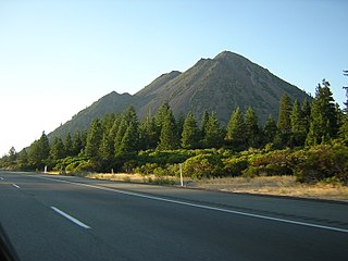
Black Butte is a cluster of overlapping dacite lava domes in a butte, a parasitic cone of Mount Shasta. It is located directly adjacent to Interstate 5 at milepost 742 between the city of Mount Shasta and Weed, California. The highway crosses a 3,912 ft (1,192 m) pass, Black Butte Summit, at the western base of the lava domes. The lava domes were extruded at the foot of the cone of Shastina following the period of its major eruptions about 9,000–10,000 years ago.

The Black Rock Range is a mountain range in northwestern Nevada. It is named for Black Rock Point, which is located at the southern end of the range. The Black Rock Range divides the Black Rock Desert into eastern and western arms. Pahute Peak, also known as Big Mountain, is the highest point in the range at 8,566 feet (2,611 m) above sea level.

Calico Mountains Wilderness is a U S Wilderness Area in Nevada under the Bureau of Land Management. It is located in the Calico Hills.

The Black Rock Desert Wilderness is a U S Wilderness Area in Nevada under the Bureau of Land Management. It is located in the east arm of the Black Rock Desert playa east of the Black Rock Range and west of the Jackson Mountains. The wilderness has a land area of 314,829 acres, or 1,274.1 km². It is the largest U.S. designated wilderness area that is managed solely by the Bureau of Land Management, and the largest that is not located within a National Forest, National Park, or National Wildlife Refuge. It is located within the Black Rock Desert – High Rock Canyon Emigrant Trails National Conservation Area, also managed by the BLM.

The North Jackson Mountains Wilderness is a U S Wilderness Area in Nevada under the Bureau of Land Management. It is located in the Jackson Mountains north of the South Jackson Mountains Wilderness and east of the Black Rock Desert Wilderness.

The South Jackson Mountains Wilderness is a U S Wilderness Area in Nevada under the Bureau of Land Management. It is located in the Jackson Mountains, south of the North Jackson Mountains Wilderness and east of the Black Rock Desert Wilderness.
Many Antarctic research stations support satellite field camps which are, in general, seasonal camps. The type of field camp can vary – some are permanent structures used during the annual Antarctic summer, whereas others are little more than tents used to support short term activities. Field camps are used for many things, from logistics to dedicated scientific research.
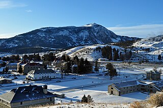
Bunsen Peak el. 8,564 feet (2,610 m) is a prominent peak due south of Mammoth Hot Springs in Yellowstone National Park, Wyoming. The peak lies on the east flank of Kingman Pass on the Mammoth to Norris section of the Grand Loop Road. The peak was first ascended by Ferdinand V. Hayden and Captain John W. Barlow in 1871, Bunsen Peak was not named until 1872 during the second Hayden Geologic Survey. E. S. Topping named the peak Observation Mountain in 1872 as well, but that name did not stick. The Bunsen Peak Trail with its trailhead just south of Mammoth is a steep 2.1 miles (3.4 km) to the summit. Bunsen Peak was named for the German chemist Robert Bunsen, the inventor of the Bunsen Burner and responsible for early work on volcanic geyser theories.

The natural environment of Virginia encompasses the physical geography and biology of the U.S. state of Virginia. Virginia has a total area of 42,774.2 square miles (110,784.67 km2), including 3,180.13 square miles (8,236.5 km2) of water, making it the 35th-largest state by area. Forests cover 65% of the state, wetlands and water cover 6% of the land in the state, while 5% of the state is a mixture of commercial, residential, and transitional.

Black Mountain is a prominent mountain summit in the Elkhead Mountains range of the Rocky Mountains of North America. The 10,865-foot (3,312 m) peak is located in Routt National Forest, 20.9 miles (33.6 km) north-northeast of the City of Craig in Moffat County, Colorado, United States. Black Mountain is the highest point in Moffat County.

Fortification Hill is a prominence adjacent to Lake Mead in the Lake Mead National Recreation Area; it is located at the northwest terminus region of the Black Mountains (Arizona), and specifically the north region of the Black Mountains. It is near a southern section of Lake Mead, and just northeast of Hoover Dam. It can easily be seen eastward across Las Vegas Bay or from the two northern mountain terminuses of Eldorado Mountains (Nevada), or the Black Mountains (Arizona).
