
The Adirondack Mountains form a massif in northeastern New York, United States. Its boundaries correspond to the boundaries of Adirondack Park. The mountains form a roughly circular dome, about 160 miles (260 km) in diameter and about 1 mile (1,600 m) high. The current relief owes much to glaciation.

Black Brook is a town in Clinton County, New York, United States. The population was 1,497 at the 2010 census. It is named after a stream that flows through the town.

A tarn is a mountain lake, pond or pool, formed in a cirque excavated by a glacier. A moraine may form a natural dam below a tarn.
At 47,527 acres (192.33 km2), Harriman State Park is the second largest state park in New York State. Located in Rockland and Orange counties 30 miles (48 km) north of New York City, it is a haven for hikers with over 200 miles (320 km) of hiking trails. The park is also known for its 31 lakes, multiple streams, public camping area, and great vistas. The park's hiking trails are currently maintained by volunteers from the New York - New Jersey Trail Conference.

The Oswegatchie River is a 137-mile-long (220 km) river in northern New York that flows from the Adirondack Mountains north to the Saint Lawrence River. The Oswegatchie River begins at Partlow Lake in Hamilton County, New York. The river continues through Cranberry Lake which was 'doubled in size' through construction of a dam in the late 1860s. The river continues from the dam to Gouverneur, to near Talcville in St. Lawrence County, where it joins the West Branch. Much of it is within Adirondack State Park. The city of Ogdensburg developed at the mouth of the river at its confluence with the St. Lawrence.

Hempstead Lake State Park is a 737-acre (2.98 km2) state park located in Nassau County, New York in the United States. The park is located in West Hempstead and is one of three state parks within the Town of Hempstead. There is a quick-access entrance at exit 18 from the Southern State Parkway. The park contains the largest freshwater lake in Nassau County.

Grafton Lakes State Park is a 2,545-acre (10.30 km2) state park located in Rensselaer County, New York, United States. The park is in the central part of the Town of Grafton and north of the hamlet of Grafton on NY Route 2, northeast of Albany. The park contains the Shaver Pond Nature Center.

The Saint Regis Canoe Area in Adirondack Park is the largest wilderness canoe area in the Northeastern United States and the only designated canoe area in New York state. It is closed to motorized vehicles. Among the 58 ponds and lakes are Upper Saint Regis Lake, part of the Seven Carries route, and Saint Regis Pond. It contains the headwaters of the West and Middle Branch of the Saint Regis and the Saranac Rivers. Only two of the lakes can be reached without a portage, or carry as it's known in the region. Primitive canoe camping is permitted on many of the lakes and ponds. Saint Regis Mountain and Long Pond Mountain are within the area.
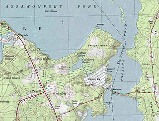
Pocksha Pond is a lake/reservoir/pond within the towns of Lakeville and Middleboro, in southeastern Massachusetts. It shares its waters with Great Quittacas Pond and openly connected with Assawompset Pond. These lakes provides a source of drinking water to the city of New Bedford, the largest city in southeastern Massachusetts.

Country Pond is a 306-acre (124 ha) water body located in Rockingham County in southern New Hampshire, United States, in the towns of Kingston and Newton. Water from Country Pond flows via the Powwow River to the Merrimack River in Amesbury, Massachusetts.

Powder Mill Pond is a 419-acre (1.70 km2) impoundment on the Contoocook River in Hillsborough County in southern New Hampshire, United States. The pond's dam is located in the town of Bennington, with water impounded into the towns of Hancock and Greenfield.

Balch Pond is a 577-acre (2.34 km2) water body located on the New Hampshire-Maine border, in the towns of Wakefield, New Hampshire, and Acton and Newfield, Maine. A northwest portion of the lake in New Hampshire is known as Stump Pond. Water flows from the eastern end of Balch Pond into the Little Ossipee River, a tributary of the Saco River.

Powwow Pond is a 348-acre (1.41 km2) water body in Rockingham County in southeastern New Hampshire, United States. The outlet of the pond is located in the town of East Kingston, but most of the lake lies in the town of Kingston. The Powwow River, the outlet of the pond, flows to the Merrimack River in Amesbury, Massachusetts.
Thompson Pond in Pine Plains, New York is a 75-acre (30 ha) 15,000-year-old glacial kettle pond at the foot of 1,403-foot (428 m) Stissing Mountain. It is the source of Wappinger Creek, a tributary of the Hudson River that drains much of Dutchess County.
Harrisville Pond is a 138-acre (0.56 km2) water body located in Cheshire County in southwestern New Hampshire, United States, in the town of Harrisville. It is one of many lakes and ponds along Nubanusit Brook, a tributary of the Contoocook River. Water from Nubanusit Lake flows via the Great Meadows into the pond on the north side and out of the pond at two dams on the south side. One dam allows the level of the pond to be raised or lowered and also adjusts the flow through the mills that span that part of the outlet, while the other dam is made of large stones and sandbags. The village of Harrisville is located at the outlet of the pond.

Chub Lake is a lake located west of Raquette Lake, New York. Fish species present in the lake are black bullhead, and brook trout. There is trail access on the south and west shore from the north shore of Constable Pond. No motors are allowed on Chub Lake.
Cedar Lake is located northwest of Sled Harbor, New York. Fish species present in the lake are brook trout, black bullhead, and white sucker. There is trail access on the north and west shores from Sled Harbor. There is also trail access to Whitney Lake. No motors are allowed on this lake.
Lizard Pond is located in the Adirondack Mountains southwest of Garnet Lake, New York. Fish species present in the lake are brook trout, and black bullhead. There is carry down trail access off Garnet Lake on the southeast shore.
