Black Sea drainage basin

Last updated

The drainage basin of the Black Sea is served by approximately 25 large rivers flowing from 24 countries in central, eastern and southeastern Europe, Anatolia and the Caucasus.

Contents

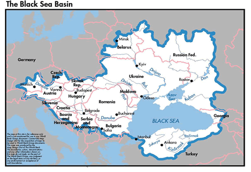
Most prominent river basins

Prominent rivers of the Black sea drainage basin are the Danube, Dnieper, Don, Dniester, and Kuban.

Danube river basin

The Danube river runs through the largest number of countries in the world (the Nile is second with 9 countries). Originating in Germany, the Danube flows southeast for 2,850 km (1,770 mi), passing through or bordering Austria, Slovakia, Hungary, Croatia, Serbia, Romania, Bulgaria, Moldova and Ukraine before draining into the Black Sea. Its drainage basin extends into nine more countries.

The Danube river basin is home to fish species such as pike, zander, huchen, Wels catfish, burbot and tench. It is also home to a large diversity of carp and sturgeon, as well as salmon and trout. A few species of euryhaline fish, such as European seabass, mullet, and eel, inhabit the Danube Delta and the lower portion of the river.

Since ancient history, the Danube has been a traditional trade route in Europe. Today, 2,415 km (1,501 mi) of its total length are navigable. The river is also an important source of hydropower and drinking water.

Dnieper river basin

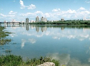
The Dnieper rises in the Valdai Hills near Smolensk, Russia, before flowing through Belarus and Ukraine to the Black Sea. It is the longest river of Ukraine and Belarus and the fourth-longest river in Europe, after Volga, Danube and Ural. The total length is approximately 2,200 km (1,400 mi) [1] with a drainage basin of 504,000 square kilometres (195,000 sq mi). Historically, the river was an important barrier, dividing Ukraine into right and left banks. Nowadays, the river is noted for its dams and hydroelectric stations. The Dnieper is an important navigable waterway for the economy of Ukraine and is connected via the Dnieper–Bug Canal to other waterways in Europe.

The total length of the river is variously given as 2,145 kilometres (1,333 mi) [1] or 2,201 km (1,368 mi), [2] [3] [4] [5] of which 485 km (301 mi) are within Russia, 700 km (430 mi) are within Belarus, [1] and 1,095 km (680 mi) are within Ukraine. Its basin covers 504,000 square kilometres (195,000 sq mi), of which 289,000 km2 (112,000 sq mi) are within Ukraine, [6] 118,360 km2 (45,700 sq mi) are within Belarus. [1]

The source of the Dnieper is the sedge bogs (Akseninsky Mokh) of the Valdai Hills in central Russia, at an elevation of 220 m (720 ft). [6] For 115 km (71 mi) of its length, it serves as the border between Belarus and Ukraine. Its estuary, or liman, used to be defended by the strong fortress of Ochakiv.[ citation needed ]

The southernmost point in Belarus is on the Dnieper to the south of Kamaryn in Brahin Raion. [7] The Dnieper has many tributaries (up to 32,000) with 89 being rivers of 100+ km. [8]

Don river basin

The Don is the fifth-longest river in Europe. Flowing from Central Russia to the Sea of Azov in Southern Russia, it is one of Russia's largest rivers and played an important role for traders from the Byzantine Empire. The Don rises in the town of Novomoskovsk 60 kilometres (37 mi) southeast of Tula (in turn 193 kilometres (120 mi) south of Moscow), and flows 1,870 kilometres to the Sea of Azov.

The Don 's basin is between the Dnieper basin to the west, the lower Volga basin immediately to the east, and the Oka basin (tributary of the Volga) to the north. Native to much of the basin were Slavic nomads. [9]

Dniester river basin

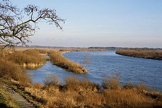
The Dniester rises in Ukraine, near the city of Drohobych, close to the border with Poland, and flows toward the Black Sea. Its course marks part of the border of Ukraine and Moldova, after which it flows through Moldova for 398 kilometres (247 mi), separating the main territory of Moldova from its breakaway region Transnistria. It later forms an additional part of the Moldova-Ukraine border, then flows through Ukraine to the Black Sea, where its estuary forms the Dniester Liman.

Kuban river basin


The Kuban river originates on the slopes of Mount Elbrus and forms at the merger of its two tributaries, Ullukam and Uchkulam; from the source of Ullukam to the delta, it has a length of 906 kilometres (563 mi). Between the source and Nevinnomyssk the river flows mostly in the deep and narrow gorge, has many thresholds and rapidly changes its elevation. At 116 kilometres (72 mi) from the mouth, the Kuban converges with a major tributary, the Protoka, which is 130 kilometres (81 mi) long. Near its mouth the Kuban narrows to 3 to 4 kilometres (1.9 to 2.5 mi) and then forms a delta covering about 4,300 square kilometres (1,700 sq mi). The delta contains numerous limans, some of which have gradually separated from the river. Until the 19th century the Kuban River discharged into both the Black and the Azov seas. However later, the rising grounds redirected the river entirely to the Azov Sea. [10] [11] [12] Azov Sea is a sea in Eastern Europe connected to the Black Sea by the narrow (about 4 km or 2.5 mi) Strait of Kerch, and is sometimes regarded as a northern extension of the Black Sea. [13] [14]

The average discharge of the Kuban River is at its maximum near Krasnodar at about 425 cubic metres per second (15,000 cu ft/s). It was formerly higher by some 30 cubic metres per second (1,100 cu ft/s) but was lowered by the reservoir construction. The average discharge near Armavir is 163 cubic metres per second (5,800 cu ft/s), and it formerly varied between 0.95 and 1,160 cubic metres per second (34 and 40,965 cu ft/s) before the filling of the Krasnodar Reservoir in the 1980s. The annual outflow to the Azov Sea is about 12 to 13 cubic kilometres (2.9 to 3.1 cu mi) of water, 8 million tonnes of sediments and 4 million tonnes of dissolved salts. [12]

The average turbidity is 682 g/m3. Water salinity increases toward the delta; it normally varies between 50 and 400 mg/L and may reach 1000 mg/L in some areas. All major tributaries flow into the Kuban from the left and originate in the Caucasus Mountains. Those tributaries include the Bolshoy Zelenchuk, Maly Zelenchuk, Urup, Laba, Belaya and Pshish. [10] [11] [12]

Largest rivers

Largest rivers flowing into the Black Sea : [15]

  1. Danube
  2. Dnieper
  3. Don
  4. Dniester
  5. Kızılırmak
  6. Kuban
  7. Sakarya
  8. Southern Bug
  9. Çoruh
  10. Yeşilırmak
  11. Rioni
  12. Yeya
  13. Mius
  14. Kamchiya
  15. Enguri
  16. Kalmius
  17. Molochna
  18. Tylihul
  19. Velykyi Kuyalnik
  20. Veleka
  21. Rezovo
  22. Kodori
  23. Bzyb
  24. Supsa
  25. Mzymta

Basin countries

Black Sea Basin countries, 2-million km2 (0.77-million sq mi) basin and 24 countries : [16] [17] [18] [19] [20]

  1. Flag of Albania.svg  Albania
  2. Flag of Austria.svg  Austria
  3. Flag of Belarus.svg  Belarus
  4. Flag of Bosnia and Herzegovina.svg  Bosnia and Herzegovina
  5. Flag of Bulgaria.svg  Bulgaria
  6. Flag of Croatia.svg  Croatia
  7. Flag of the Czech Republic.svg  Czech Republic
  8. Flag of Italy.svg  Italy
  9. Flag of Georgia.svg  Georgia
  10. Flag of Germany.svg  Germany
  11. Flag of Greece.svg  Greece
  12. Flag of Hungary.svg  Hungary
  13. Flag of North Macedonia.svg  North Macedonia
  14. Flag of Montenegro.svg  Montenegro
  15. Flag of Moldova.svg  Moldova
  16. Flag of Poland.svg  Poland
  17. Flag of Serbia.svg  Serbia
  18. Flag of Slovakia.svg  Slovakia
  19. Flag of Slovenia.svg  Slovenia
  20. Flag of Switzerland.svg   Switzerland
  21. Flag of Romania.svg  Romania
  22. Flag of Russia.svg  Russia
  23. Flag of Turkey.svg  Turkey
  24. Flag of Ukraine.svg  Ukraine

Related Research Articles

Geography of Romania Overview of the geography of Romania

With an area of 238,397 km2 (92,046 sq mi), Romania is the twelfth-largest country in Europe. Located in Southeastern Europe, bordering on the Black Sea, the country is halfway between the equator and the North Pole and equidistant from the westernmost part of Europe—the Atlantic Coast—and the most easterly—the Ural Mountains. Romania has 3,195 kilometres (1,985 mi) of border. Republic of Moldova and Ukraine lie to the east, Bulgaria lies to the south, and Serbia and Hungary to the west. In the southeast, 245 kilometres (152 mi) of sea coastline provide an important outlet to the Black Sea and the Atlantic Ocean.

Geography of Ukraine Geography of the country Ukraine

The geography of Ukraine varies greatly from one region of the country to another, with the majority of the country lying within the East European Plain. Ukraine is the second-largest country by area in Europe. Its various regions have diverse geographic features ranging from highlands to lowlands, as well as climatic range and a wide variety in hydrography.

Transport in Ukraine includes ground transportation, water, air transportation, and pipelines. The transportation sector accounts for roughly 11% of the country's gross domestic product and 7% of total employment.

Sea of Azov Sea on the south of Eastern Europe linked to the Black Sea

The Sea of Azov is a sea in Eastern Europe connected to the Black Sea by the narrow Strait of Kerch, and is sometimes regarded as a northern extension of the Black Sea. The sea is bounded in the northwest by Ukraine, in the southeast by Russia. The Don and Kuban are the major rivers that flow into it. There is a constant outflow of water from the Sea of Azov to the Black Sea.

Ural (river) Major river in Russia and Kazakhstan

The Ural, known as Yaik before 1775, is a river flowing through Russia and Kazakhstan in the continental border between Europe and Asia. It originates in the southern Ural Mountains and discharges into the Caspian Sea. At 2,428 kilometres (1,509 mi), it is the third-longest river in Europe after the Volga and the Danube, and the 18th-longest river in Asia. The Ural is conventionally considered part of the boundary between the continents of Europe and Asia.

Dniester River in Eastern Europe

The Dniester is a river in Eastern Europe. It runs first through Ukraine and then through Moldova, finally discharging into the Black Sea on Ukrainian territory again.

Dnieper Longest river of Ukraine and Belarus

The Dnieper is one of the major rivers of Europe, rising in the Valdai Hills near Smolensk, Russia, before flowing through Belarus and Ukraine to the Black Sea. It is the longest river of Ukraine and Belarus and the fourth-longest river in Europe, after Volga, Danube and Ural. The total length is approximately 2,200 km (1,400 mi) with a drainage basin of 504,000 square kilometres (195,000 sq mi). Historically, the river was an important barrier, dividing Ukraine into right and left banks. Nowadays, the river is noted for its dams and hydroelectric stations. The Dnieper is an important navigable waterway for the economy of Ukraine and is connected via the Dnieper–Bug Canal to other waterways in Europe.

Kuban (river) River in the North Caucasus region of Russia

The Kuban is a river in the Northwest Caucasus region of European Russia. It flows mostly through Krasnodar Krai for 660 kilometres (410 mi) but also in the Karachay–Cherkess Republic, Stavropol Krai and the Republic of Adygea.

Donets

The Seversky Donets, Siverskyi Donets, usually simply called the Donets, is a river on the south of the East European Plain. It originates in the Central Russian Upland, north of Belgorod, flows south-east through Ukraine and then again through Russia to join the river Don, about 100 km (62 mi) from the Sea of Azov. The Donets is the fourth longest river in Ukraine and the biggest in the Eastern Ukraine. It is an important source of fresh water in the east of the country. It gives its name to the Donets Basin, known commonly as the Donbass, an important coal mining region in Ukraine.

Bug (river)

The Bug or Western Bug is a major river mostly located in Eastern Europe, which flows through three countries with a total length of 774 kilometres (481 mi).

East European Plain Vast interior plain east of the North/Central European

The East European Plain is a vast interior plain extending east of the North European Plain, and comprising several plateaus stretching roughly from 25 degrees longitude eastward. It includes the westernmost Volhynian-Podolian Upland, the Central Russian Upland, and on the eastern border, encompasses the Volga Upland. The plain includes also a series of major river basins such as the Dnepr Basin, the Oka–Don Lowland, and the Volga Basin. Along the southernmost point of the East European Plain are the Caucasus and Crimean mountain ranges. Together with the North European Plain, and covering the Baltics, Moldova, south-eastern Romania, and its most southern expansion – the Danubian Plain in Northern Bulgaria,, it constitutes the majority of the Great European Plain, the greatest mountain-free part of the European landscape.

Liman (landform) Landform, formed at the mouth of a river where flow is blocked by a bar of sediments

Liman is defined in Bulgarian, Ukrainian (лиман), Russian (лиман) and Romanian (liman) as an enlarged estuary formed as a lagoon at the wide mouth of one or several rivers, where flow is constrained by a bar of sediments, as in the Dniester Liman or the Razelm liman. A liman can be maritime or fluvial. The term describes many wet estuaries in the Black Sea and the Sea of Azov; a synonymous term guba (губа) is used in Russian sources for estuaries of the Russian shores in the north.

Racer goby Species of fish

The racer goby is a species of goby native to fresh, sometimes brackish, waters, of the Black Sea basin. It is a Ponto-Caspian relict species. The species is placed a monotypic genus, Babka, which was once considered a subgenus of genus Neogobius, but was then elevated to genus-status based on the molecular analysis.

The Ubort is a river in the Zhytomyr Oblast (Ukraine) and the Homiel Voblast (Belarus), a right tributary to the Pripyat in the Dnieper river basin. It is 292 kilometres (181 mi) long, and has a drainage basin of 5,820 square kilometres (2,250 sq mi).

Beysug

The Beysug is a river in Krasnodar Krai of Russia. It is 243 kilometres (151 mi) long, with a drainage basin of 5,190 square kilometres (2,000 sq mi). It flows into the Sea of Azov through the Beysugsky Liman. To the south is the river Kuban, to the immediate north the Chelbas, and further to the north the Yeya.

Danube River in Central and Eastern Europe

The Danube is the second-longest river in Europe, after the Volga in Russia. It flows through much of Central and Southeastern Europe, from the Black Forest into the Black Sea. Its longest headstream Breg rises in Furtwangen im Schwarzwald, while the river carries its name from its source confluence in Donaueschingen onwards.

Kuchurhan (river)

The Kuchurhan is a river in Eastern Europe. It is a tributary of the Turunchuk which begins on the Podolian Upland in Ukraine. It then flows SSE and forms part of the border between Transnistria in Moldova and the Odessa Oblast in Ukraine. The river is 109 kilometres (68 mi) long and drains 2,090 square kilometres (810 sq mi).

References

  1. 1 2 3 4 "Main Geographic Characteristics of the Republic of Belarus. Main characteristics of the largest rivers of Belarus". Land of Ancestors. Data of the Ministry of Natural Resources and Environmental Protection of the Republic of Belarus. 2011. Retrieved 27 September 2013.
  2. Zastavnyi, F. D. (2000). Physical Geography of Ukraine. Rivers of Ukraine. Dnieper. Forum. Kyiv.
  3. Masliak, P.; Shyshchenko, P. (1998). Heohrafii︠a︡ Ukraïny[Geography of Ukraine]. Zodiak-eko. Kyiv. ISBN   966-7090-06-X.
  4. "Website about Dnieper". Archived from the original on 21 February 2014. Retrieved 6 February 2014.
  5. Mishyna, Liliana. Hydrographic research of Dnieper river Archived 4 March 2016 at the Wayback Machine . Derzhhidrohrafiya.
  6. 1 2 Kubiyovych, Volodymyr; Ivan Teslia. "Dnieper River". Encyclopedia of Ukraine. Retrieved 19 January 2007.
  7. "Main Geographic Characteristics of the Republic of Belarus. Coordinates of the extreme points of the state frontier". Land of Ancestors. The Scientific and Production State Republican Unitary Enterprise "National Cadastre Agency" of the State Property Committee of the Republic of Belarus. 2011. Retrieved 20 September 2013.
  8. Splendid Dnieper. There is no straighter river. Ukrinform. 4 July 2015
  9. Basilevsky, Alexander. (2016-03-23). Early Ukraine : a military and social history to the mid-19th century. ISBN   978-0-7864-9714-0. OCLC   898167561.
  10. 1 2 Kuban River [ permanent dead link ], Great Soviet Encyclopedia (in Russian)
  11. 1 2 428: Kuban Archived 2011-10-05 at the Wayback Machine , Freshwater Ecoregions of the World
  12. 1 2 3 Kuban - the major river of the region (in Russian)
  13. "Sea of Azov". Encyclopædia Britannica. Retrieved 2015-11-26.
  14. "Map of Sea of Azov". worldatlas.com. Retrieved 2015-11-26.
  15. "Black Sea NGO Network | Our Black Sea". www.bsnn.org.
  16. "Marine Litter Report". www.blacksea-commission.org.
  17. Aydin, Mustafa (2005). "Europe's new region: The Black Sea in the wider Europe neighbourhood". Southeast European and Black Sea Studies. 5 (2): 257–283. doi:10.1080/14683850500122943. S2CID   154395443.
  18. "Black Sea".
  19. "UN Atlas of the Oceans: Subtopic". www.oceansatlas.org.
  20. http://www.fao.org/fileadmin/user_upload/oceanatlas/img/1132587048006_BSBasinPolitical.gif