
Omagh is the county town of County Tyrone, Northern Ireland. It is situated where the rivers Drumragh and Camowen meet to form the Strule. Northern Ireland's capital city, Belfast, is 68 miles (109.5 km) to the east of Omagh, and Derry is 34 miles (55 km) to the north.

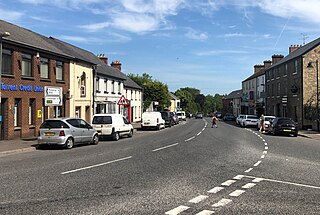
Dromore is a town, townland and civil parish in County Tyrone, Northern Ireland. It is nine miles (14 km) south west of Omagh on the A32 and sixteen miles (26 km) from Enniskillen. The population of Dromore was 1,198 at the 2011 Census.

Creggan is a townland in County Tyrone, Northern Ireland. It is situated in the historic barony of Omagh East and the civil parish of Termonmaguirk and covers an area of 4022 acres.

Drumquin is a village and townland in County Tyrone, Northern Ireland. It lies between Omagh and Castlederg, on the banks of the Drumquin River (Fairywater). It is situated in the civil parishes of both Longfield West and Longfield East. The main part of the village is located in Longfield East, in the townland of Drumnaforbe, whilst Longfield West is where its namesake townland Drumquin is located. Drumquin is in the historic barony of Omagh West.

Artigarvan is a village and townland in County Tyrone, Northern Ireland. It is 3 miles from Strabane and 4 miles from Dunnamanagh, within the Strabane District Council area. It is called Airtigarvan in Ulster-Scots.
Donaghmore is a village, townland and civil parish in County Tyrone, Northern Ireland, about five kilometres (3 mi) north-west of Dungannon. In the 2011 Census it had a population of 1,122 people. The village is beside the River Torrent, formerly known as the Torrent Flow.

Caledon is a small village and townland in County Tyrone, Northern Ireland. It is in the Clogher Valley on the banks of the River Blackwater, 10 km from Armagh. It lies in the southeast of Tyrone and near the borders of County Armagh and County Monaghan. It is situated in the historic barony of Dungannon Lower and the civil parish of Aghaloo. In the 2001 Census it had a population of 387 people. It is a designated conservation area. It was historically known as Kinnaird.

Altamuskin or Altamooskan is a small village and townland in County Tyrone, Northern Ireland. It is situated in the historic barony of Clogher and the civil parish of Errigal Keerogue and covers an area of 1165 acres. In the 2014 Census Altamuskin had a population of 127 people. It lies within the Fermanagh and Omagh District Council area and is home to St Bridget's Altamuskin. The population of the townland declined during the 19th century:

Drumnakilly .) is a small village and townland between Carrickmore and Omagh in County Tyrone, Northern Ireland. In the 2001 Census it had a population of 114 people. The townland is situated in the historic barony of Strabane Upper and the civil parish of Termonmaguirk and covers an area of 1,352 acres. It lies within the Omagh District Council area.

Ardstraw is a small village, townland and civil parish in County Tyrone, Northern Ireland, three miles northwest of Newtownstewart. In the 2001 Census it had a population of 222 people.

Killen is a small village and townland in County Tyrone, Northern Ireland. It is several miles southwest of Castlederg, on the road leading south over Scraghy Mountain. A short distance to the west lies County Donegal, in the Republic of Ireland. It is situated in the civil parish of Longfield West and the historic barony of Omagh West. In the 2001 Census it had a population of 231 people.
Cappagh is a small village and townland in the parish of Pomeroy in County Tyrone, Northern Ireland. Around 10 kilometres (6 mi) north-west of Dungannon, it is between Pomeroy, Ballygawley, Galbally and Carrickmore, with the hamlet of Galbally about one mile to the east. Most of the land around Cappagh is farmland although a quarry lies just outside the village. In County Tyrone, there is also the parish of Cappagh which includes part of the town of Omagh and small village of Mountfield.
Altmore ) is a hamlet and townland in County Tyrone, Northern Ireland. It is five miles from Carrickmore and four miles from Pomeroy. The townland is actually called Altmore and is situated in the historic barony of Dungannon Middle and the civil parish of Pomeroy and covers an area of 1117 acres.

Killyman is a small village and a civil parish in Northern Ireland, situated on the eastern boundary of County Tyrone and extending into County Armagh. The majority of townlands are in the historic barony of Dungannon Middle in County Tyrone, the rest being in the barony of Oneilland West in County Armagh.
Altishane or Altishahane is a small settlement and townland in County Tyrone, Northern Ireland. It lies near Strabane, between Plumbridge and Donemana. It is situated in the historic barony of Strabane Lower and the civil parish of Donaghedy and covers an area of 744 acres. There is one primary school, Altishane Primary School.
Killeeshil is a townland and civil parish in County Tyrone, Northern Ireland. It is situated in the historic barony of Dungannon Lower. Killeeshil is home to their local community centre which helps the local community throughout killeeshil parish. They work with trustees but mainly volunteer work.

Lisbunny is a townland of 849 acres in County Londonderry, Northern Ireland, about 3 miles Claudy, near the County Tyrone/Londonderry border. It is situated within Derry and Strabane district as well as the civil parish of Cumber Upper and the historic barony of Tirkeeran.

Glencull is a townland in County Tyrone, Northern Ireland. It is situated in the historic barony of Dungannon Lower and the civil parish of Killeeshil and covers an area of 241 acres and is the only exclave of killeeshil

