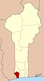
Mono is one of the twelve departments of Benin, with its capital at Lokossa. It is named for the Mono River which forms much of the border with Togo. The northern areas of the department were split off to create the newly formed Kouffo Department in 1999. Mono is subdivided into six communes, each centred at one of the principal towns, namely, Athiémè, Bopa, Comè, Grand-Popo, Houéyogbé and Lokossa. It has an area of 1,396 square kilometres (539 sq mi).
Aplahoué is a town and arrondissement in Benin, and is the capital of the Kouffo Department. The commune covers an area of 572 square kilometres and as of 2013 had a population of 170,069 people.

Athiémè is a town and arrondissement located in the Mono Department of Benin. The commune covers an area of 220 square kilometres and as of 2013 had a population of 56,483 people.
The departments of Benin are subdivided into 77 communes, which in turn are divided into arrondissements and finally into villages or city districts. Prior to 1999 provinces were broken down into 84 districts, titled either urban or rural. Before independence, the six provinces were subdivided into Cercles, cantons, préfectures and villages or towns.
Lalo is a town, arrondissement, and commune in the Kouffo Department of south-western Benin. The commune covers an area of 432 square kilometres and as of 2013 had a population of 119,926 people.
Toviklin is a town, arrondissement, and commune in the Kouffo Department of south-western Benin. The commune covers an area of 120 square kilometres and as of 2013 had a population of 88,611 people.
Houéyogbé is a town, arrondissement, and commune in the Mono Department of south-western Benin. The commune covers an area of 290 square kilometres and as of 2002 had a population of 74,492 people.
Avrankou is a town, arrondissement, and commune in the Ouémé Department of south-eastern Benin. The commune covers an area of 150 square kilometres and as of 2013 had a population of 128,050 people.
Bonou is a town, arrondissement, and commune in the Ouémé Department of south-eastern Benin. The commune covers an area of 275 square kilometres and as of 2002 had a population of 29,656 people.

Sèmè-Kpodji is a town, arrondissement, and commune in the Ouémé Department of south-eastern Benin. The commune covers an area of 250 square kilometres and as of 2013 had a population of 222,701 people.
Agbangnizoun is a town, arrondissement, and commune in the Zou Department of south-western Benin. The town lies 20 kilometres south-east of Abomey. The commune covers an area of 244 square kilometres and as of 2002 had a population of 55,001 people.
Zogbodomey or Zogbodomè is a town, arrondissement, and commune in the Zou Department of south-western Benin. The commune covers an area of 600 square kilometres and as of 2002 had a population of 72,338 people.
Bengou is a village and rural commune in Niger. The elevation in Bengou is 571 ft (174m). A 2012 census reports the Bengou population at 13,452.
Tori-Cada is a town and arrondissement in the Atlantique Department of southern Benin. It is an administrative division under the jurisdiction of the commune of Tori-Bossito. According to the population census conducted by the Institut National de la Statistique Benin on February 15, 2002, the arrondissement had a total population of 11,952.
Agbodji is an arrondissement in the Mono department of Benin. It is an administrative division under the jurisdiction of the commune of Bopa. According to the population census conducted by the Institut National de la Statistique Benin on February 15, 2002, the arrondissement had a total population of 8,376.
Badazoui is an arrondissement in the Mono department of Benin. It is an administrative division under the jurisdiction of the commune of Bopa. According to the population census conducted by the Institut National de la Statistique Benin on February 15, 2002, the arrondissement had a total population of 12,362.
Gbakpodji is an arrondissement in the Mono department of Benin. It is an administrative division under the jurisdiction of the commune of Bopa. According to the population census conducted by the Institut National de la Statistique Benin on February 15, 2002, the arrondissement had a total population of 5,509.
Lobogo is an arrondissement in the Mono department of Benin. It is an administrative division under the jurisdiction of the commune of Bopa. According to the population census conducted by the Institut National de la Statistique Benin on February 15, 2002, the arrondissement had a total population of 17,622.
Possotomè is an arrondissement in the Mono department of Benin. It is an administrative division under the jurisdiction of the commune of Bopa. According to the population census conducted by the Institut National de la Statistique Benin on February 15, 2002, the arrondissement had a total population of 6,889.
Yégodoé is an arrondissement in the Mono department of Benin. It is an administrative division under the jurisdiction of the commune of Bopa. According to the population census conducted by the Institut National de la Statistique Benin on February 15, 2002, the arrondissement had a total population of 10,304.