
A ring road is a road or a series of connected roads encircling a town, city, or country. The most common purpose of a ring road is to assist in reducing traffic volumes in the urban centre, such as by offering an alternate route around the city for drivers who do not need to stop in the city core.

Boston is a town and small port in Lincolnshire, on the east coast of England, about 100 miles (160 km) north of London. It is the largest town of the wider Borough of Boston local government district. The town itself had a population of 35,124 at the 2001 census, while the borough had a total population of 66,900, at the ONS mid-2015 estimates. It is north of Greenwich on the Prime Meridian.

U.S. Route 1 or U.S. Highway 1 (US 1) is a major north–south United States Numbered Highway that serves the East Coast of the United States. It runs 2,369 miles (3,813 km), from Key West, Florida north to Fort Kent, Maine, at the Canadian border, making it the longest north–south road in the United States. US 1 is generally paralleled by Interstate 95 (I-95), though the former is significantly farther west (inland) between Jacksonville, Florida, and Petersburg, Virginia. The highway connects most of the major cities of the East Coast—including Miami, Jacksonville, Richmond, Washington, D.C., Baltimore, Philadelphia, New York City, and Boston passing from the Southeastern United States to New England.

Coronary artery bypass surgery, also known as coronary artery bypass graftsurgery, and colloquially heart bypass or bypass surgery, is a surgical procedure to restore normal blood flow to an obstructed coronary artery. A normal coronary artery transports blood to and from the heart muscle itself, not through the main circulatory system.

The A52 is a major road in the East Midlands, England. It runs east from a junction with the A53 at Newcastle-under-Lyme near Stoke-on-Trent via Ashbourne, Derby, Stapleford, Nottingham, West Bridgford, Bingham, Grantham, Boston and Skegness to the east Lincolnshire coast at Mablethorpe. It is approximately 147 miles (237 km) long.

U.S. Route 3 (US 3) is a United States highway running 277.9 miles (447.2 km) from Boston, Massachusetts, through New Hampshire, to the Canada–US border near Third Connecticut Lake, where it connects to Quebec Route 257.
U.S. Route 58 is an east–west U.S. Highway that runs for 508 miles (818 km) from U.S. Route 25E just northwest of Harrogate, Tennessee, to U.S. Route 60 in Virginia Beach, Virginia. Until 1996, when the Cumberland Gap Tunnel opened, US 58 ran only inside the commonwealth of Virginia. It was then extended southwest along a short piece of former US 25E, which no longer enters Virginia, to end at the new alignment in Tennessee.

Washington Street is a street originating in downtown Boston, Massachusetts that extends southwestward to the Massachusetts–Rhode Island state line. The majority of it was built as the Norfolk and Bristol Turnpike in the early 19th century. It is the longest street in Boston, and it remains one of the longest streets in the state of Massachusetts.
U.S. Route 1A is the name of several highways found in the United States.

The A16 road is a principal road of Lincolnshire in the East Midlands region of England, connecting the port of Grimsby and Peterborough, where it meets the A1175, A47 & A1139 then on to the A1 and the A605 the latter, in turn, giving a through route to Northampton and the west, and south west of England. Its length is 78 miles (126 km). The road was "de-trunked", with responsibility largely returned to Lincolnshire County Council from the Highways Agency in 2002.
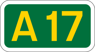
The A17 road is a road linking Newark-on-Trent in Nottinghamshire, England, to King's Lynn in Norfolk. It stretches for a distance of 62 miles travelling across the flat Fen landscapes of southern Lincolnshire and western Norfolk.

A bypass is a road or highway that avoids or "bypasses" a built-up area, town, or village, to let through traffic flow without interference from local traffic, to reduce congestion in the built-up area, and to improve road safety. A bypass specifically designated for trucks may be called a truck route.
Vincent F. Zarrilli is a businessman who oversees cookware and pottery manufacture at The Pot Shop of Boston in Massachusetts.

Arborway consists of a four-lane, divided parkway and a two lane residential street in the Jamaica Plain neighborhood of Boston, Massachusetts. It was designed by Frederick Law Olmsted in the 1890s as the south most carriage road in a series of parkways connecting parks from Boston Common in downtown Boston to Franklin Park in Roxbury. This park system has since become known as the Emerald Necklace of Boston.

Elections for Boston Borough Council, which covers the Borough of Boston, were held on 3 May 2007. The Boston Bypass Independents won the election in a landslide victory with 25 seats, the first party ever to take overall control of the council since the borough was formed in 1973. It was a single-issue party campaigning on getting a bypass for Boston. All the Labour and Liberal Democrat councillors lost their seats, with only five Conservatives and two Independents also elected. The turnout was 36.9%. The overall results, were as follows:
The Boston Bypass Independents were elected to Boston Borough Council at the 2007 local elections. The party campaigned on a wide range of issues but principally on the more vigorous promotion of a bypass for the town of Boston, Lincolnshire.
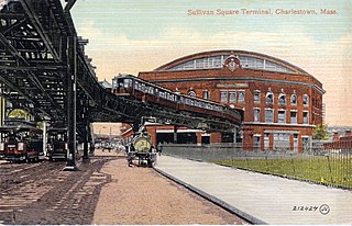
Sullivan Square is a traffic circle located in the Charlestown neighborhood of Boston, Massachusetts. The MBTA's Sullivan Square station is located to the west of the square. Adjacent to the East Somerville area of Somerville, Sullivan Square is named after James Sullivan, an early 19th-century Governor of Massachusetts. In the early 2000s, the Sullivan Square Overpass was dismantled, which left a stub approach to Route 99.

The Lincolnshire loop line was a 58-mile (93 km) double-track railway built by the Great Northern Railway, that linked Peterborough to Lincoln via Spalding and Boston.
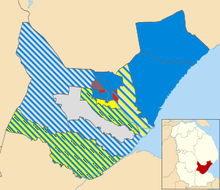
Elections for Boston Borough Council, which covers the Borough of Boston, were held on Thursday 5 May 2011. The Conservatives became the first of the main political parties to win an overall majority on the council since the borough was formed in 1973 with 19 seats. The Boston Bypass Independents were almost wiped out, retaining only four seats. The remaining opposition is made up of four Independents, three Labour and two English Democrat councillors. The overall results, were as follows:
Elections for Boston Borough Council, which governs as a second-tier authority the Borough of Boston were held on Thursday 7 May 2015. Following Boundary Commission changes between this election and the previous in 2011 to the wards, 30 councillors were elected to serve 15 wards. The election was held on the same day as other local elections.