
Iqaluit is the capital of the Canadian territory of Nunavut, its largest community, and its only city. It was known as Frobisher Bay from 1942 to 1987, after the large bay on the coast of which the city is situated. In 1987, its traditional Inuktitut name was restored.
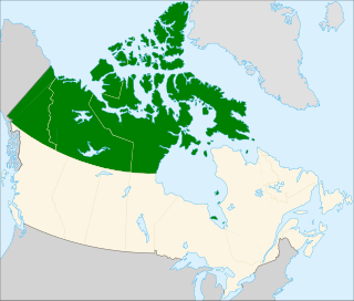
Northern Canada, colloquially the North, is the vast northernmost region of Canada variously defined by geography and politics. Politically, the term refers to three territories of Canada: Yukon, Northwest Territories, and Nunavut. Similarly, the Far North may refer to the Canadian Arctic: the portion of Canada that lies north of the Arctic Circle, east of Alaska and west of Greenland. This area covers about 39% of Canada's total land area, but has less than 1% of Canada's population.

Arctic Bay is an Inuit hamlet located in the northern part of the Borden Peninsula on Baffin Island in the Qikiqtaaluk Region of Nunavut, Canada. Arctic Bay is located in the Eastern Time Zone although it is quite close to the time zone boundary. The predominant languages are Inuktitut and English. At the 2016 census the population had increased by 5.5% from the 2011 census to 868. Arctic Bay is notable for being the birthplace of the former Premier of Nunavut Eva Aariak.

Cambridge Bay is a hamlet located on Victoria Island in the Kitikmeot Region of Nunavut, Canada. It is the largest settlement on Victoria Island. Cambridge Bay is named for Prince Adolphus, Duke of Cambridge, while the traditional Inuinnaqtun name for the area is Ikaluktutiak or Iqaluktuttiaq meaning "good fishing place".

Melville Peninsula is a large peninsula in the Canadian Arctic north of Hudson Bay. To the east is Foxe Basin and to the west the Gulf of Boothia. To the north the Fury and Hecla Strait separates it from Baffin Island. To the south Repulse Bay and Frozen Strait separate it from Southampton Island at the north end of Hudson Bay. On the southwest it is connected to the mainland by the "Rae Isthmus" named after arctic explorer Dr John Rae.

The British Arctic territories, now known as the Arctic Archipelago were claimed by the United Kingdom in North America. The region was part of British North America.
The Canadian territory of Nunavut covers about 1.9 million square kilometres of land and water including part of the mainland, most of the Arctic Islands, and all of the islands in Hudson Bay, James Bay, and Ungava Bay which belonged to the Northwest Territories. This makes it the fifth largest country subdivision in the world. If Nunavut were a country, it would rank 13th in area, after the Democratic Republic of the Congo. Nunavut has land borders with Manitoba, the Northwest Territories on several islands as well as the mainland, and a tiny land border with Newfoundland and Labrador on Killiniq Island.

Nunavut is the newest, largest, and most northerly territory of Canada. It was separated officially from the Northwest Territories on April 1, 1999, via the Nunavut Act and the Nunavut Land Claims Agreement Act, though the boundaries had been drawn in 1993. The creation of Nunavut resulted in the first major change to Canada's political map since incorporating the province of Newfoundland in 1949.

Promise Island is located near the western shore of Hudson Bay. It is barely a square kilometre in area and rises 300 ft (91 m) in elevation on its northern side. It is located about 9 km (5.6 mi) from the community of Chesterfield Inlet, Nunavut, Canada, and is part of a loose chain of small islands running along the coast, including the Wag Islands and Pitsiulartok.

North Twin Island is an uninhabited Arctic island located east of Akimiski Island in James Bay on the southern end of Hudson Bay. The smaller, similarly-shaped, South Twin Island is located approximately 10 km southeast. Together, they are known as the Twin Islands, and are part of the Qikiqtaaluk Region of the Canadian territory of Nunavut.

The Low Islands are one of the many uninhabited Canadian arctic island groups in Qikiqtaaluk Region, Nunavut. They are located in Ungava Bay, stretching between Young Island to the south and Lookout Island to the north.
Ogden Bay is an Arctic waterway in Kitikmeot Region, Nunavut, Canada. It is located in the southern Queen Maud Gulf off Nunavut's mainland. Chester Bay is situated 32 km (20 mi) to the west, Armark is to the east, and the Keith Islands are to the north.
Aupaluktut Island is an uninhabited Baffin Island offshore island located in the Canadian Arctic Archipelago in Nunavut's Qikiqtaaluk Region. It lies in Cumberland Sound, between Brown Inlet and Ikpit Bay. It rises approximately 30 m (98 ft) above sea level. Nuvujen Island lies to its north. Robert Peel Inlet is due south, approximately 29.4 km (18.3 mi) away.
Opingivik Island is an uninhabited Baffin Island offshore island located in the Canadian Arctic Archipelago in Nunavut's Qikiqtaaluk Region. It lies in Cumberland Sound between Ikpit Bay to the north and Robert Peel Inlet approximately 18.6 km (11.6 mi) to the south.
The Sheer Islands are Canadian arctic islands that are located in Qikiqtaaluk Region, Nunavut, Canada. They are a Baffin Island offshore island group in Hudson Strait. The islands are situated approximately 1 mi (1.6 km) north of Cape Tanfield and form part of the north side of Itivirk Bay.
The Solomons Temple Islands are an uninhabited Canadian arctic islands group located within the midsection of James Bay in Nunavut, Canada. They are situated north of Charlton Island, and southwest of Paint Hills Islands, Pointe au Huard and Andrew Moar Bay,
Macormick Bay is an Arctic waterway in Qikiqtaaluk Region, Nunavut, Canada. It lies off the southwestern coast of Devon Island in the eastern high Arctic. Like Baring Bay to the north, it is an arm of Wellington Channel.
Okse Bay is an Arctic waterway in Qikiqtaaluk Region, Nunavut, Canada. It is located in Norwegian Bay by southwestern Ellesmere Island, east of Buckingham Island.
The Gretha Islands are an uninhabited island group located in the Qikiqtaaluk Region of Nunavut, Canada. They are situated in Eureka Sound at the confluence of Bay Fjord, north of Ellesmere Island's Raanes Peninsula, and east of Stor Island. They are members of the Sverdrup Islands group, Queen Elizabeth Islands, and the Canadian Arctic Archipelago.
