Bremen Island

Last updated
Bremen Island
Antarctica location map.svg
Red pog.svg
Bremen Island
Location in Antarctica
Geography
Location Antarctica
Coordinates 64°19′19″S62°56′06″W / 64.322°S 62.935°W / -64.322; -62.935
Archipelago Melchior Islands,
Palmer Archipelago
Area1 km2 (0.39 sq mi)
Administration
Administered under the Antarctic Treaty System
Demographics
PopulationUninhabited

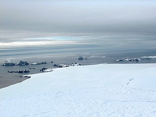
Bremen Island (German : Bremeninsel) is a 1 km2 (0.39 sq mi) or 100 ha (247 acres) uninhabited island, part of the Melchior Islands in the Southern Ocean along the west coast of the Antarctic Peninsula.

German language West Germanic language

German is a West Germanic language that is mainly spoken in Central Europe. It is the most widely spoken and official or co-official language in Germany, Austria, Switzerland, South Tyrol (Italy), the German-speaking Community of Belgium, and Liechtenstein. It is also one of the three official languages of Luxembourg and a co-official language in the Opole Voivodeship in Poland. The languages which are most similar to German are the other members of the West Germanic language branch: Afrikaans, Dutch, English, the Frisian languages, Low German/Low Saxon, Luxembourgish, and Yiddish. There are also strong similarities in vocabulary with Danish, Norwegian and Swedish, although those belong to the North Germanic group. German is the second most widely spoken Germanic language, after English.

Melchior Islands group of many low, ice-covered islands

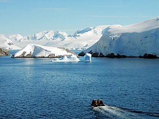
The Melchior Islands are a group of many low, ice-covered islands lying near the center of Dallmann Bay in the Palmer Archipelago, Antarctica. They were first seen but left unnamed by a German expedition under Eduard Dallmann, 1873–74. The islands were resighted and roughly charted by the Third French Antarctic Expedition under Jean-Baptiste Charcot, 1903–05. Charcot named what he believed to be the large easternmost island in the group "Île Melchior" after Vice Admiral Jules Melchior of the French Navy, but later surveys proved Charcot's Île Melchior to be two islands, now called Eta Island and Omega Island. The name Melchior Islands has since become established for the whole island group now described, of which Eta Island and Omega Island form the eastern part, while the Sigma Islands mark the northern limit of the islands. The group was roughly surveyed in 1927 by Discovery Investigations personnel in the RRS Discovery, and was resurveyed by Argentine expeditions in 1942 and 1943, and again in 1948.

Southern Ocean The ocean around Antarctica

The Southern Ocean, also known as the Antarctic Ocean or the Austral Ocean, and the "Southern Icy Ocean".</ref> comprises the southernmost waters of the World Ocean, generally taken to be south of 60° S latitude and encircling Antarctica. As such, it is regarded as the fourth largest of the five principal oceanic divisions: smaller than the Pacific, Atlantic, and Indian Oceans but larger than the Arctic Ocean. This ocean zone is where cold, northward flowing waters from the Antarctic mix with warmer subantarctic waters.

Contents

A 1 km (0.62 mi) long channel ( Bremenkanal ) separates Omega Island and Bremen Island. The existence of the channel was discovered during a zodiac excursion on 2 February 2003 by the German cruise ship MS Bremen , [1] named after the German city of Bremen. The name "Bremen Island" was proposed by Bärbel Krämer of Hapag-Lloyd.

Omega Island island

Omega Island is an island 3.7 kilometres (2 nmi) long, which lies immediately south of Eta Island in the Melchior Islands, Palmer Archipelago. This island, the largest feature in the southeast part of the Melchior Islands, is part of what was called Île Melchior by the French Antarctic Expedition under Jean-Baptiste Charcot, 1903–05, but the name Melchior now applies for the whole island group. Omega Island was roughly surveyed by DI personnel in 1927. The name Omega, derived from the last letter of the Greek alphabet, appears to have been first used on a 1946 Argentine government chart following surveys of the Melchior Islands by Argentine expeditions in 1942 and 1943.

Germany Federal parliamentary republic in central-western Europe

Germany, officially the Federal Republic of Germany, is a country in Central and Western Europe, lying between the Baltic and North Seas to the north, and the Alps to the south. It borders Denmark to the north, Poland and the Czech Republic to the east, Austria and Switzerland to the south, France to the southwest, and Luxembourg, Belgium and the Netherlands to the west.

Cruise ship passenger ship used for pleasure voyages

A cruise ship is a passenger ship used for pleasure voyages when the voyage itself, the ship's amenities, and sometimes the different destinations along the way, form part of the passengers' experience. Transportation is not the only purpose of cruising, particularly on cruises that return passengers to their originating port. On "cruises to nowhere" or "nowhere voyages", cruise ships make 2-to-3 night round trips without any ports of call.

Coordinates: 64°19′19″S62°56′06″W / 64.322°S 62.935°W / -64.322; -62.935

Geographic coordinate system Coordinate system

A geographic coordinate system is a coordinate system that enables every location on Earth to be specified by a set of numbers, letters or symbols. The coordinates are often chosen such that one of the numbers represents a vertical position and two or three of the numbers represent a horizontal position; alternatively, a geographic position may be expressed in a combined three-dimensional Cartesian vector. A common choice of coordinates is latitude, longitude and elevation. To specify a location on a plane requires a map projection.

See also

Scientific Committee on Antarctic Research organization

The Scientific Committee on Antarctic Research (SCAR) is an interdisciplinary body of the International Council for Science (ICSU).

Territorial claims in Antarctica Wikimedia list article

Seven sovereign states maintain a territorial claim on eight territories in Antarctica. These countries have tended to place their Antarctic scientific observation and study facilities within their respective claimed territories. A number of such facilities are located nowhere near their country's sector, however. Many nations such as Russia and the US have no claim anywhere in Antarctica, yet have large research facilities within the sectors of foreign countries.

Related Research Articles

Ficheto Point

Ficheto Point is an ice-free point on the northeast coast of Varna Peninsula, Livingston Island, Antarctica forming the southeast side of the entrance to Dragon Cove. Channel Rock is lying in the adjacent northwestern part of McFarlane Strait, 1.3 km (0.81 mi) northeast of Ficheto Point and 920 m (1,010 yd) south-southwest of Meade Islands. The area was visited by 19th century sealers.

Thamyris Glacier glacier in Antarctica

Thamyris Glacier is a 3 km long and 2.8 km wide glacier draining the east slopes of the Trojan Range on Anvers Island in the Palmer Archipelago, Antarctica. Situated east of Iliad Glacier, south of Rhesus Glacier and northwest of Kleptuza Glacier. Flowing northeastwards into Fournier Bay south of Predel Point and north of Madzharovo Point.

Rabisha Rocks

Rabisha Rocks is a group of rocks off the north coast of Greenwich Island in the South Shetland Islands, Antarctica situated 1.5 km (0.93 mi) northeast of Voluyak Rocks, 1.3 km (0.81 mi) north of Kabile Island and 1.8 km (1.12 mi) west of Ongley Island.

Tvarditsa Rocks

Tvarditsa Rocks is a group of rocks off the north coast of Greenwich Island in the South Shetland Islands, Antarctica situated 1.9 km (1.2 mi) northeast of Ongley Island, 1.3 km (0.81 mi) southwest of Stoker Island and 2.6 km (1.6 mi) west of Sierra Island.

Buchino Rocks

Buchino Rocks is a group of rocks off the north coast of Greenwich Island in the South Shetland Islands, Antarctica situated 1.5 km (0.93 mi) northwest of Stoker Island, 1.6 km (0.99 mi) southeast of Romeo Island and 1.9 km (1.2 mi) north-northwest of Tvarditsa Rocks.

Okol Rocks

Okol Rocks is a group of rocks in the north of Aitcho Islands group on the west side of English Strait in the South Shetland Islands, Antarctica. The principal feature in the group is Lambert Island (62°22′16″S59°45′49″W).

Mitev Glacier

Mitev Glacier is the 2.9 km long and 2.5 km wide glacier on Brabant Island in the Palmer Archipelago, Antarctica situated east of Laennec Glacier. It drains the north slopes of Avroleva Heights and flows northeastwards to enter Hill Bay west of Petroff Point.

Chumerna Glacier glacier in Antarctica

Chumerna Glacier is the 2.2 km long and 1.9 km wide glacier draining the north slopes of Stavertsi Ridge on Albena Peninsula, Brabant Island in the Palmer Archipelago, Antarctica. It flows northeastwards to enter the channel between Brabant Island and Liège Island east of Hales Peak.

Barrientos Island

Barrientos Island is an ice-free island in the Aitcho group on the west side of English Strait in the South Shetland Islands, Antarctica. Extending 1.71 by 0.54 km, surface area 65 hectares. The area was visited by early 19th century sealers. Barrientos Island is a popular tourist site frequented by Antarctic cruise ships.

Ash Point

Ash Point is a rounded low ice-free point forming the southeast side of the entrance to Discovery Bay in the northeast of Greenwich Island in the South Shetland Islands, Antarctica with an adjacent ice-free area of 201 hectares. Letelier Bank is lying off Ash Point, while Bascopé Point is situated 460 m (503 yd)to the southwest, with the 1 km (0.62 mi) wide Rojas Cove indenting for 310 m (339 yd) the coast between that point and Guesalaga Peninsula. The area was visited by early 19th century sealers.

Table Island (South Shetland Islands)

Table Island is a conspicuous flat-topped, rocky island lying north of Greenwich Island and north-northwest of the Aitcho group on the west side of English Strait in the South Shetland Islands, Antarctica. The island is rising to over 150 metres and extending 1.4 by 1 kilometre, with a surface area of 112 hectares. It is separated from Aitcho Islands to the south-southeast by the 1.9-kilometre (1.2-mile) wide Klimash Passage.

Ongley Island

Ongley Island is a rugged rocky island lying off the north coast of Greenwich Island in the South Shetland Islands, Antarctica. Extending 1.35 km (0.84 mi) in west-northwest direction and 470 m (510 yd) wide, with a surface area of 44 hectares. The area was visited by early 19th century sealers.

Romeo Island

Romeo Island is a rocky island lying off the north coast of Greenwich Island and west of Aitcho Islands in the South Shetland Islands, Antarctica. Extending 1.35 km (0.84 mi) in west-northwest direction and 470 m (510 yd) wide, with a surface area of 44 hectares. The area was visited by early 19th century sealers.

Pyramid Island, South Shetland Islands island of the South Shetland Islands

Pyramid Island is a conspicuous, pillar-shaped rocky island rising to 205 m (673 ft) off the north entrance to McFarlane Strait in the South Shetland Islands, Antarctica. Its surface area is 9 hectares. Cone Rock
(62°25′56.9″S60°06′08.3″W) is rising to 6 m (19.7 ft) 1.33 km (0.83 mi) south of the island,
2.03 km (1.26 mi) north-northwest of Meade Islands, 2.8 km (1.7 mi) northeast of Williams Point and
1.65 km (1.03 mi) east of Koshava Island, Zed Islands. The vicinity of Pyramid Island was visited on 19 February 1819 during the discovery of the South Shetlands by Captain William Smith in the British brig Williams, and later by early 19th century sealers.

Cornwall Island (Antarctica)

Cornwall Island is a low ice-free island off the north coast of Robert Island in the South Shetland Islands, Antarctica. Surface area 15 hectares. Mónica Rock is lying 1.65 km (1.03 mi) west of the island and 3.4 km (2.1 mi) north of Passage Rock, 2.84 km (1.76 mi) east of Table Island and 2 km (1.2 mi) south of Potmess Rocks. The area was visited by early 19th century sealers operating from nearby Clothier Harbour.

Craggy Island (Livingston Island) Antarctic island

Craggy Island is a narrow island marked by crags, lying in Hero Bay, Livingston Island in the South Shetland Islands, Antarctica and forming the northeast side of Blythe Bay. Its surface area is 9 hectares .) The area was frequented by early nineteenth century English and American sealers operating from Blythe Bay.

Chaos Reef landform

Chaos Reef is the confused area of breakers and shoal water in the north extremity of Aitcho Islands group on the west side of English Strait in the South Shetland Islands, Antarctica. The area was visited by early 19th century sealers operating from nearby Clothier Harbour.

Mellona Rocks

Mellona Rocks is a group of scattered rocks lying at the north entrance to Nelson Strait in the South Shetland Islands, Antarctica and extending 1.7 by 0.9 km. The area was known to the early 19th-century sealers and sometimes included under the names 'Heywood Islands' or 'Powels Islands'.

Skrino Rocks

Skrino Rocks is the chain of rocks off the east coast of Robert Island in the South Shetland Islands, Antarctica, extending 570 m (623 yd) in east-west direction.

Vodoley Rock

Vodoley Rock is the rock extending 220 m in northwest-southeast direction and 110 m wide in Barclay Bay on the west side of Ioannes Paulus II Peninsula on Livingston Island in the South Shetland Islands, Antarctica. The area was visited by early 19th century sealers operating on nearby Byers Peninsula and Cape Shirreff.

References

  1. "Antarctic Gazetteer - Bremeninsel" . Retrieved 16 October 2009.