Brillion, Wisconsin

Last updated

Brillion, Wisconsin
Brillion Wisconsin Downtown Looking North.jpg
Calumet County Wisconsin Incorporated and Unincorporated areas Brillion Highlighted.svg
Location of Brillion in Calumet County, Wisconsin.
Coordinates: 44°10′30″N88°3′58″W / 44.17500°N 88.06611°W / 44.17500; -88.06611
Country Flag of the United States.svg  United States
State Flag of Wisconsin.svg  Wisconsin
County Calumet
Area
[1]
  Total2.86 sq mi (7.41 km2)
  Land2.84 sq mi (7.36 km2)
  Water0.02 sq mi (0.05 km2)
Elevation
[2]
830 ft (253 m)
Population
 (2020) [3]
  Total3,262
  Estimate 
(2023) [4]
3,466
  Density1,082.69/sq mi (418.00/km2)
Time zone UTC-6 (Central (CST))
  Summer (DST) UTC-5 (CDT)
Zip Code
54110
Area code 920
FIPS code 55-09725 [5]
GNIS feature ID1562211 [2]
Website www.ci.brillion.wi.us

Brillion is a city in Calumet County in the U.S. state of Wisconsin. The population was 3,466 as of May 30, 2023. The city is located within the Town of Brillion, though it is politically independent.

Contents

History

Brillion is named after the town of Brilon, in Germany. [6]

Geography

Brillion is located at 44°10′30″N88°3′57″W / 44.17500°N 88.06583°W / 44.17500; -88.06583 (44.175114, −88.0661). [7]

According to the United States Census Bureau, the city has a total area of 2.75 square miles (7.12 km2), of which, 2.73 square miles (7.07 km2) is land and 0.02 square miles (0.05 km2) is water. [8]

Demographics

Historical population
CensusPop.Note
1880 278
1890 582109.4%
1900 85546.9%
1910 99816.7%
1920 1,10210.4%
1930 1,1675.9%
1940 1,2002.8%
1950 1,39015.8%
1960 1,78328.3%
1970 2,58845.1%
1980 2,90712.3%
1990 2,840−2.3%
2000 2,9373.4%
2010 3,1487.2%
2020 3,2623.6%
2023 (est.)3,466 [4] 6.3%
U.S. Decennial Census [9]

2010 census

As of the census [3] of 2010, there were 3,148 people, 1,298 households, and 851 families living in the city. The population density was 1,153.1 inhabitants per square mile (445.2/km2). There were 1,349 housing units at an average density of 494.1 per square mile (190.8/km2). The racial makeup of the city was 97.1% White, 0.2% African American, 0.5% Native American, 0.2% Asian, 0.9% from other races, and 1.2% from two or more races. Hispanic or Latino of any race were 2.8% of the population.

There were 1,298 households, of which 32.8% had children under the age of 18 living with them, 52.7% were married couples living together, 7.8% had a female householder with no husband present, 5.1% had a male householder with no wife present, and 34.4% were non-families. 29.7% of all households were made up of individuals, and 15.7% had someone living alone who was 65 years of age or older. The average household size was 2.42 and the average family size was 3.01.

The median age in the city was 37.8 years. 25.5% of residents were under the age of 18; 7% were between the ages of 18 and 24; 27.1% were from 25 to 44; 24.1% were from 45 to 64; and 16.2% were 65 years of age or older. The gender makeup of the city was 49.4% male and 50.6% female.

2000 census

As of the census [5] of 2000, there were 2,937 people, 1,155 households, and 818 families living in the city. The population density was 1,128.8 people per square mile (436.1/km2). There were 1,230 housing units at an average density of 472.7 per square mile (182.7/km2). The racial makeup of the city was 98.64% White, 0.72% Native American, 0.17% Asian, 0.17% from other races, and 0.31% from two or more races. 0.51% of the population were Hispanic or Latino of any race.

There were 1,155 households, out of which 32.6% had children under the age of 18 living with them, 60.6% were married couples living together, 7.7% had a female householder with no husband present, and 29.1% were non-families. 25.2% of all households were made up of individuals, and 12.3% had someone living alone who was 65 years of age or older. The average household size was 2.53 and the average family size was 3.03.

In the city, the population was spread out, with 26.3% under the age of 18, 8.2% from 18 to 24, 29.1% from 25 to 44, 21.9% from 45 to 64, and 14.6% who were 65 years of age or older. The median age was 36 years. For every 100 females, there were 95.7 males. For every 100 females age 18 and over, there were 93.2 males.

The median income for a household in the city was $46,633, and the median income for a family was $52,989. Males had a median income of $37,106 versus $24,318 for females. The per capita income for the city was $20,754. About 1.6% of families and 2.5% of the population were below the poverty line, including 0.8% of those under age 18 and 7.1% of those age 65 or over.

Education

Brillion High School is the area's high school.

Trinity Lutheran School is a Christian Pre-K–8 school of the Wisconsin Evangelical Lutheran Synod in Brillion. [10]

Images

Notable people

Related Research Articles

<span class="mw-page-title-main">Glenwood, Alabama</span> Town in Alabama, United States

Glenwood is a town in Crenshaw County, Alabama, United States. At the 2020 census, the population was 152. Glenwood was incorporated in 1907.

<span class="mw-page-title-main">Dot Lake, Alaska</span> CDP in Alaska, United States

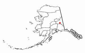
Dot Lake is a census-designated place (CDP) in Southeast Fairbanks Census Area, Alaska, United States. It is located on the Alaska Highway between Delta Junction and Tok. The population was 13 at the 2010 census, down from 19 in 2000.

<span class="mw-page-title-main">Naalehu, Hawaii</span> Census-designated place in Hawaii, U.S.

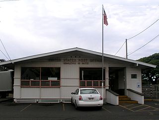
Nāʻālehu is a community in Hawaiʻi County, Hawaii, United States. Nāʻālehu is Hawaiian for "the volcanic ashes". It is one of the southernmost communities with a post office in the 50 states of the United States. For statistical purposes, the United States Census Bureau has defined Naalehu as a census-designated place (CDP). The census definition of the area may not precisely correspond to local understanding of the area with the same name. The population was 866 at the 2010 census, down from 919 at the 2000 census.

<span class="mw-page-title-main">Crainville, Illinois</span> Village in Illinois, United States

Crainville is a village in Williamson County, Illinois, United States. The population was 1,254 at the 2010 census.

<span class="mw-page-title-main">Boxholm, Iowa</span> City in Iowa, United States

Boxholm is a city in Grant Township, Boone County, Iowa, United States. The population was 181 at the 2020 census. It is part of the Boone, Iowa Micropolitan Statistical Area, which is a part of the larger Ames-Boone, Iowa Combined Statistical Area.

<span class="mw-page-title-main">Hamlin, Maine</span> Town in the state of Maine, United States

Hamlin is a town in Aroostook County, Maine, United States. It is located on the Canada–US border with a border crossing into Grand Falls, New Brunswick and is the closest continental location to Europe in the United States. Hamlin's northeastern corner is the closest point in the mainland United States to Western Europe, situated at a distance of 2,508 miles (4,018 km) from the closest point in Europe to the USA, Achill Head. The population was 166 at the 2020 census.

<span class="mw-page-title-main">Acomita Lake, New Mexico</span> Census-designated place in New Mexico, United States

Acomita Lake is a census-designated place (CDP) in Cibola County, New Mexico, United States. The population was 339 at the 2020 census.

<span class="mw-page-title-main">Martin, South Dakota</span> City in South Dakota, United States

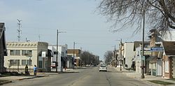
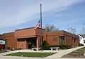
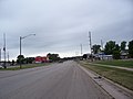
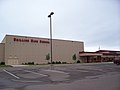
Martin is a city and the county seat of Bennett County, South Dakota, United States. The population was 938 at the 2020 census.

<span class="mw-page-title-main">Greenwood, Wisconsin</span> City in Wisconsin, United States

Greenwood is a city in Clark County in the U.S. state of Wisconsin. The population was 1,026 at the 2010 census.

<span class="mw-page-title-main">Oliver, Wisconsin</span> Village in Wisconsin, United States

Oliver is a village in Douglas County, Wisconsin, United States. The population was 423 at the 2020 census.

<span class="mw-page-title-main">Schofield, Wisconsin</span> City in Wisconsin, United States

Schofield is a city in Marathon County, Wisconsin, United States. It is part of the Wausau, Wisconsin Metropolitan Statistical Area. The population was 2,157 at the 2020 census. The city was named for William Scholfield, who came to the area in the 1851 to open a sawmill. The city has since dropped the "L" from its name.

<span class="mw-page-title-main">Amery, Wisconsin</span> City in Wisconsin, United States

Amery is a city in Polk County, Wisconsin, United States, along the Apple River. It is a part of Wisconsin's 7th congressional district. The population was 2,902 at the 2010 census. The city was named in honor of William Amery, a carpenter who held several local offices in the 1870s.

<span class="mw-page-title-main">Osseo, Wisconsin</span> City in Wisconsin, United States

Osseo is a city located in Trempealeau County, Wisconsin, at the confluence of the North and South Forks of the Buffalo River. The population was 1,701 at the 2010 census.

<span class="mw-page-title-main">Pittsville, Wisconsin</span> City in Wisconsin, United States

Pittsville is a city in Wood County, Wisconsin, United States. The population was 874 at the 2010 census.

<span class="mw-page-title-main">Barron, Wisconsin</span> City in Wisconsin, United States

Barron is a city in Barron County, in the U.S. state of Wisconsin. The population was 3,423 at the 2010 census. The city is surrounded by the Town of Barron.

<span class="mw-page-title-main">Brillion (town), Wisconsin</span>

Brillion is a town in Calumet County in the U.S. state of Wisconsin. The population was 1,486 at the 2010 census.

<span class="mw-page-title-main">Loyal, Wisconsin</span> City in Wisconsin, United States

Loyal is a city in Clark County in the U.S. state of Wisconsin. The population was 1,261 at the 2010 census. The city is located within the Town of Loyal, though it is politically independent.

<span class="mw-page-title-main">Thorp, Wisconsin</span> City in Wisconsin, United States

Thorp is a city in Clark County in the U.S. state of Wisconsin. The population was 1,621 at the 2010 census. The city is located partially within the Town of Thorp and partially within the Town of Withee.

<span class="mw-page-title-main">Montello, Wisconsin</span> City in Wisconsin, United States

Montello is a city in and the county seat of Marquette County, Wisconsin, United States. The population was 1,495 at the 2010 census. The Fox River flows through the city. Montello is home to the largest tree in Wisconsin. A notable attraction in the city is the former granite quarry, which has been transformed into a park with several waterfalls.

<span class="mw-page-title-main">Hillsboro, Wisconsin</span> City in Wisconsin, United States

Hillsboro is a city in Vernon County, Wisconsin, United States. The population was 1,397 at the 2020 Census. The city is located within the Town of Hillsboro. Hillsboro is known as the Czech Capital of Wisconsin.

References

  1. "2019 U.S. Gazetteer Files". United States Census Bureau. Retrieved August 7, 2020.
  2. 1 2 "US Board on Geographic Names". United States Geological Survey. October 25, 2007. Retrieved January 31, 2008.
  3. 1 2 "U.S. Census website". United States Census Bureau . Retrieved November 18, 2012.
  4. 1 2 "Population and Housing Unit Estimates". United States Census Bureau. May 24, 2020. Retrieved May 27, 2020.
  5. 1 2 "U.S. Census website". United States Census Bureau . Retrieved January 31, 2008.
  6. Chicago and North Western Railway Company (1908). A History of the Origin of the Place Names Connected with the Chicago & North Western and Chicago, St. Paul, Minneapolis & Omaha Railways. p. 46.
  7. "US Gazetteer files: 2010, 2000, and 1990". United States Census Bureau. February 12, 2011. Retrieved April 23, 2011.
  8. "US Gazetteer files 2010". United States Census Bureau. Archived from the original on January 25, 2012. Retrieved November 18, 2012.
  9. "Census of Population and Housing". Census.gov. Retrieved June 4, 2015.
  10. "WELCOME TO TRINITY LUTHERAN SCHOOL" . Retrieved January 18, 2020.