Normanton is a small cattle town and locality in the Shire of Carpentaria in Queensland, Australia. In the 2016 census, Normanton had a population of 1,210 people of whom 743 were Indigenous Australians.
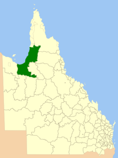
The Shire of Carpentaria is a local government area in Far North Queensland, Australia on the Gulf of Carpentaria, for which it is named.
Queensland is the second-largest and third-most populous state in the Commonwealth of Australia. Situated in the north-east of the country, it is bordered by the Northern Territory, South Australia and New South Wales to the west, south-west and south respectively. To the east, Queensland is bordered by the Coral Sea and Pacific Ocean. To its north is the Torres Strait, with Papua New Guinea located less than 200 km across it from the mainland. The state is the world's sixth-largest sub-national entity, with an area of 1,852,642 square kilometres (715,309 sq mi).
On 11 February 1861, four members of the Burke and Wills expedition attempting to cross the Australian continent from south to north, established their most northerly campsite adjacent the Bynoe River (west of the Norman River) in the Gulf of Carpentaria. Two of the party camped at this location for three days while expedition leader Robert O'Hara Burke and surveyor William John Wills ventured further north in an attempt to reach the Gulf coast. During their occupation of the site, the party blazed 15 trees to mark its location. A search party led by Frederick Walker arrived in the area 11 months later, on 8 January 1862, and also established a camp on a small seasonal lagoon near Burke and Wills' Camp B/CXIX. Walker's expedition blazed a tree to record the location of their camp approximately 0.75 miles (1.21km) north of Burke and Wills' Camp B/CXIX.[1]
The Burke and Wills expedition was organised by the Royal Society of Victoria in Australia in 1860–61 of 19 men, led by Robert O'Hara Burke and William John Wills, with the objective of crossing Australia from Melbourne in the south, to the Gulf of Carpentaria in the north, a distance of around 3,250 kilometres. At that time most of the inland of Australia had not been explored by non-Indigenous people and was largely unknown to the European settlers.
The Norman River is a river in the Gulf Country, Queensland, Australia. The river originates in the Gregory Range 200 km southeast of Croydon, Queensland and flows 420 km northwest to the Gulf of Carpentaria. It is joined by three major tributaries, the Carron, Clara and Yappar Rivers. The river flows through Normanton before entering the Gulf of Carpentaria through the major fishing port of Karumba. The mouth of the river lies in the Gulf Plains Important Bird Area.
The Gulf of Carpentaria is a large, shallow sea enclosed on three sides by northern Australia and bounded on the north by the Arafura Sea. The northern boundary is generally defined as a line from Slade Point, Queensland in the northeast, to Cape Arnhem, Northern Territory in the west.
Inspired by the prevailing interest in the sciences and exploration, the Royal Society of Victoria established a committee in 1857 to "fit out" an expedition to traverse the Australian continent from "south to north". The Royal Society, a philosophical organisation whose membership came from the highest levels of society, the sciences, the squattocracy and the government in Victoria, approached the community for donations to fund the exploration. Within two years they raised over £9,000 including £6,000 from the Victorian Government. The chief aim of the expedition was to build on previous exploration work in order to open up the "centre" of the continent.[1]
The Royal Society of Victoria (RSV) is the oldest learned society in the state of Victoria in Australia.
The Australian pound was the currency of Australia from 1910 until 14 February 1966, when it was replaced by the Australian dollar. As with other £sd currencies, it was subdivided into 20 shillings, each of 12 pence.
The Royal Society advertised the position of leader of the Victorian Exploration Expedition and Robert O'Hara Burke, a police superintendent from the Castlemaine District of Victoria, was chosen to lead the expedition - a position he had anxiously and diligently pursued. Burke was born in 1821 in County Galway, Ireland, to Protestant gentry. He was educated at Woolwich and served as a lieutenant in the Austrian cavalry and later in the Irish Mounted Constabulary before emigrating to Australia in 1853.[1]
Castlemaine is a small city in Victoria, Australia, in the goldfields region of Victoria about 120 kilometres northwest by road from Melbourne and about 40 kilometres from the major provincial centre of Bendigo. It is the administrative and economic centre of the Shire of Mount Alexander. The population at the 2016 Census was 6,757. Castlemaine was named by the chief goldfield commissioner, Captain W. Wright, in honour of his Irish uncle, Viscount Castlemaine.
County Galway is a county in Ireland. It is located in the West of Ireland, part of the province of Connacht.
Woolwich is a district of south-east London, England, within the Royal Borough of Greenwich. Originally a town in Kent, it has been part of the London metropolitan area since the 19th century. In 1965, most of the former Metropolitan Borough of Woolwich became part of Greenwich Borough, of which it remains the administrative centre.
The Society chose William John Wills as the expedition's surveyor and astronomer and third-in-command behind camel master George James Landells. Wills was born in Devon, England in 1834 and trained in medicine. He emigrated to Australia in 1853 and after a short stint working as a shepherd at Deniliquin, New South Wales, he assisted in his father's medical practice at Ballarat in Victoria.[1]
Devon, also known as Devonshire, which was formerly its common and official name, is a county of England, reaching from the Bristol Channel in the north to the English Channel in the south. It is part of South West England, bounded by Cornwall to the west, Somerset to the north east, and Dorset to the east. The city of Exeter is the county town. The county includes the districts of East Devon, Mid Devon, North Devon, South Hams, Teignbridge, Torridge, and West Devon. Plymouth and Torbay are each geographically part of Devon, but are administered as unitary authorities. Combined as a ceremonial county, Devon's area is 6,707 km2 and its population is about 1.1 million.
Deniliquin, known locally as "Deni", is a town in the Riverina region of New South Wales close to the border with Victoria. It is the largest town in the Edward River Council local government area.
New South Wales is a state on the east coast of Australia. It borders Queensland to the north, Victoria to the south, and South Australia to the west. Its coast borders the Tasman Sea to the east. The Australian Capital Territory is an enclave within the state. New South Wales' state capital is Sydney, which is also Australia's most populous city. In March 2018, the population of New South Wales was over 7.9 million, making it Australia's most populous state. Just under two-thirds of the state's population, 5.1 million, live in the Greater Sydney area. Inhabitants of New South Wales are referred to as New South Welshmen.
The guidance from the Royal Society regarding the details of the expedition were unclear and it appeared from instructions presented to Burke on 16 August 1860, that he could travel in any direction he chose once he arrived at Cooper's Creek. However, there was pressure on Burke and Wills to hasten to the "centre" ahead of a rival South Australian group to be led by John McDouall Stuart, who was instructed to explore to the northwest across the continent.[1]
The Coopers Creek, a perennial stream of the Richmond River catchment, is located in Northern Rivers region in the state of New South Wales, Australia.
South Australia is a state in the southern central part of Australia. It covers some of the most arid parts of the country. With a total land area of 983,482 square kilometres (379,725 sq mi), it is the fourth-largest of Australia's states and territories by area, and fifth largest by population. It has a total of 1.7 million people, and its population is the second most highly centralised in Australia, after Western Australia, with more than 77 percent of South Australians living in the capital, Adelaide, or its environs. Other population centres in the state are relatively small; Mount Gambier, the second largest centre, has a population of 28,684.
John McDouall Stuart, often referred to as simply "McDouall Stuart", was a Scottish explorer and one of the most accomplished of all Australia's inland explorers.
Burke left Melbourne ahead of Stuart with a large party of men, stock and supplies. By the time he reached Menindee on the Darling River, it was obvious that the push north was going to be hampered by extreme summer weather and the slow speed of the drays carrying equipment and stores. Burke decided to establish a permanent camp there while waiting for the last of his equipment to arrive. Feeling that he had to continue north as quickly as possible, Burke left a party of men at Menindee and pressed on towards Cooper's Creek with a reduced team of eight men. He arranged to have the rest of the team and stores moved up to Cooper's Creek within three months.[1]
On arrival at Cooper's Creek, Burke decided to make a dash for the Gulf with Wills, Charles Gray and John King, before the wet season set in. This northern party was made up of Burke as party leader, Wills as second-in-command and astronomer, navigator and meteorologist, King as attendant to the party's camels, and Gray as camp organizer.[1]
Burke and Wills route map
Following a line to the northeast of Stuart's proposed track, Burke and his team arrived at the Little Bynoe River on 11 February 1861. They were 57 days out from Cooper's Creek and 13 days over the planned time. Burke and Wills' Camp B/CXIX became the most northern of their camps as mangroves blocked further progress to the Gulf. As they were running low on stores and concerned about meeting the remainder of the exploration party at Cooper's Creek, Burke and Wills left Gray and King at Camp B/CXIX and pushed further north through the mangroves in an attempt to reach the Gulf of Carpentaria coast. However, after three days of difficult travel, they returned south picking up Gray and King at Camp B/CXIX. The explorers left little evidence of their stay on the Gulf except for 15 blazed Coolibah and Gutta-percha trees.[1]
Most early Australian explorers marked their route of passage across the continent by blazing trees. Blazed trees identify the routes they travelled and the points along their route where they made important observations. Distinguishing markings were often cut within each blaze. The most common markings included the initials of the explorer, the date the blaze was made, and a unique number related to the progress of the expedition (e.g. the number "1" would be used to signify the location as camp number 1. Explorers were often directed by expedition organisers and sponsors on the configuration of the actual markings to be cut. B/CXIX signifies Burke's 119th camp. It was common for unique markings on blazed trees to be matched with entries made in explorers' diaries and journals. In this manner, it is sometimes possible to gain an understanding of what occurred at a particular location when little physical evidence remains.[1]
Between 14 February and 21 April 1861, the four men, with Gray sickening, struggled back towards Cooper's Creek on short supplies and with failing camels. Gray became ill suffering from pain in his head and limbs. His condition continued to deteriorate until he died on the morning of 17 April 1861.[1]
Travel had been so slow that the team at Cooper's Creek gave up hope after four months of waiting, and after burying messages and food at the foot of a tree, left the camp to go for help hours before Burke, Wills and King returned to the camp. Thinking they were alone and unaware of the buried supplies, the three men attempted to reach the nearest police station at Mount Hopeless in South Australia. However, the difficult terrain and the health of the explorers and their two remaining camels were so bad they were forced to remain along Cooper's Creek, where both Burke and Wills died in late June. King was cared for by local Aboriginal people and survived until rescued by Alfred William Howitt's search party in mid-September 1861.[1]
Apart from Howitt, others were sent to search for the lost explorers. One such person was Frederick Walker, who had already made several prospecting trips on behalf of pastoralists during 1860 and 1861. In late 1861, Walker led a party to find the Burke and Wills expedition. Walker established his own camp on a small seasonal lagoon and, during the subsequent four days, located Burke and Wills' Camp B/CXIX approximately three quarters of a mile away on the Little Bynoe River. Walker's party left several blazed trees in the vicinity of his campsite beside an overflow of the Little Bynoe River.[1]
In the early 1860s, Liddle and Hertzer established Magowra Station, which encompassed Camp B/CXIX and Walker's nearby campsite. The township of Normanton, 35 kilometres (22mi) from Camp B/CXIX, was established in 1864 as a port and service centre for the surrounding pastoral ventures and was declared a town in 1868.[1]
Burke and Wills' Camp B/CXIX and Walker's Camp remained "undiscovered" until 1909 when staff from Magowra Station found Walker's blazed trees and the blazed trees at Camp B/CXIX. JP Thomson, of the Queensland Geographical Society, published an article in the Queensland Geographical Journal 25th Session titled "Expedition to the Gulf of Carpentaria, 1909-10". Thomson located 15 blazed trees on this visit.[1]
In 1999, David Hillian revisited the site and was able to relocate 10 blazed trees. Thomson's recorded Tree Number 9 is believed to have vanished in 1997 and Number 1 was destroyed in 1999. Tree Number 6 had also been removed to be housed in the Normanton Railway Museum.[1]
Description
Map of Burke and Wills Camp B-CXIX and Walker's Camp
Burke and Wills' Camp B/CXIX and Walker's Camp are located 35 kilometres (22mi) south-west of Normanton. They are about 2 kilometres (1.2mi) south of the Normanton-Burketown Road and close to the Little Bynoe River. The sites are located above the waterline on small, seasonal overflows of the river.[1]
Both campsites are accessible via the Burke and Wills Access Road, which runs south off the Normanton-Burketown Road. Both sites are located on unremarkable, dusty landscapes showing no evidence of the dramatic events that took place there. The Burke and Wills Camp B/CXIX is marked by signs and memorials and enclosed by a graded track. Visitors are able to bring vehicles onto the site via this track.[1]
Burke and Wills' Camp B/CXIX is marked by the 10 remaining blazed trees made during the party's three day occupation of the site. These trees are located within the fringe of bush round the site and are not obviously tampered with. The blazing is unimposing but remains present on a number of trees at the camp sites. The fact that the blazes are not readily evident without examination has probably enabled most to survive.[1]
Walker's Camp lies within an overflow of the Little Bynoe River. It is marked by a single blazed tree. A stainless steel plaque which reads "Walker's Camp, 8-12th Jan 1862 DNH 1998" has been fastened to the blazed tree. Visitors to this site need to walk through bush for about 500 metres (1,600ft) to reach it.[1]
Plaque at Camp B/CXIX, 2010
Carpentaria Shire Council has completed significant signage and site protection work as part of funding received from the Community Memorial Restoration Program. Interpretative signage, bollards that protect the site and help restrict access, a protective shelter and a designated car park and access roads have all been installed on the site. None of these additions or alterations is of cultural heritage significance.[1]
Heritage listing
Burke and Wills' Camp B/CXIX and Walker's Camp, Little Bynoe River was listed on the Queensland Heritage Register on 14 August 2008 having satisfied the following criteria.[1]
The place is important in demonstrating the evolution or pattern of Queensland's history.
The Burke and Wills' Camp B/CXIX of 11–14 February 1861 and Walker's Camp of 8–12 January 1862, adjacent to the Bynoe River in the Gulf of Carpentaria, are important in demonstrating the evolution or pattern of Queensland's history in that they reflect the nineteenth century interest in scientific exploration and the exploration of central and northern Australia. The Burke and Wills Camp B/CXIX is the most northerly marked camp established during the expedition.[1]
Burke and Wills' Camp B/CXIX is important in demonstrating the pattern of exploration designed to "open up" the Australian continent for pastoralism. The process of pastoral expansion into a still largely unknown Gulf region of Queensland commenced soon after the expedition concluded, forever changing the region.[1]
The place is significant to the broader Queensland and Australian community as a symbolic representation of the past in the present, providing tangible evidence of the Burke and Wills Expedition and the search effort by Walker's party that was made to locate the lost explorers. Burke and Wills' Camp B/CXIX is significant as a landmark.[1]
The camps are also significant tangible evidence of the extent and degree to which the story of the Burke and Wills Expedition has affected the broader Queensland and Australian community.[1]
The place demonstrates rare, uncommon or endangered aspects of Queensland's cultural heritage.
The blazed trees on both the Burke and Wills' Camp B/CXIX and Walker's Camp sites, together with the "Dig Tree" at Cooper's Creek, are rare surviving and tangible evidence of the ill-fated Burke and Wills Expedition, and also of Frederick Walker's search for the lost explorers.[1]
The blazed trees are also rare in that they are still identifiable as belonging to an early exploration event and that they have also survived since 1861 in a remote and inhospitable landscape.[1]
The place has potential to yield information that will contribute to an understanding of Queensland's history.
The camps are significant in that they have the potential to yield additional archaeological evidence that may add to our store of knowledge about practices and processes of nineteenth century exploration in northern Queensland and Australia.[1]
The place has research potential, especially if other campsites from the Burke and Wills expedition are located in the future, and therefore may enable a better understanding of the hardships endured on that expedition. The place may also yield information suitable for comparative analysis with camps associated with other exploration events.[1]
The place is important in demonstrating the principal characteristics of a particular class of cultural places.
The Burke and Wills' Camp B/CXIX and Walker's Camp are significant in illustrating a principal characteristic of early exploration in Queensland - the marking of expedition campsites with blazes to record information for future travellers. The earliness, intactness, and rarity of these blazed trees makes this place an outstanding example of its type.[1]
The place has a special association with the life or work of a particular person, group or organisation of importance in Queensland's history.
Burke and Wills' Camp B/CXIX and Walker's Camp sites have a special association with the work of Robert O'Hara Burke, William John Wills and Frederick Walker who were key figures in nineteenth century Australian and Queensland exploration.[1]
See also
Other heritage listings associated with the Burke and Wills expedition include:
Menindee, frequently but erroneously spelled "Menindie", is a small town in the far west of New South Wales, Australia, in Central Darling Shire, on the banks of the Darling River, with a sign-posted population of 980 and a 2016 census population of 551.
Robert O'Hara Burke was an Irish soldier and police officer who achieved fame as an Australian explorer. He was the leader of the ill-fated Burke and Wills expedition, which was the first expedition to cross Australia from south to north, finding a route across the continent from the settled areas of Victoria to the Gulf of Carpentaria. The expedition party was well equipped, but Burke was not experienced in bushcraft. A Royal Commission report conducted upon the failure of the expedition was a censure of Burke's judgement.
William John Wills was a British surveyor who also trained as a surgeon. He achieved fame as the second-in-command of the ill-fated Burke and Wills expedition, which was the first expedition to cross Australia from south to north, finding a route across the continent from the settled areas of Victoria to the Gulf of Carpentaria.
John King was an Irish soldier who achieved fame as an Australian explorer. He was the sole survivor of the four men from the ill-fated Burke and Wills expedition who reached the Gulf of Carpentaria. The expedition was the first to cross Australia from south to north, finding a route across the continent from Melbourne in Victoria to the Gulf of Carpentaria in Queensland.
Innamincka is a small settlement in north-east South Australia, with a population of only 12. It is 821 kilometres north-east of Adelaide and 365 kilometres north-east from the closest town, Lyndhurst. It is also 66 kilometres north-east of the Moomba Gas Refinery. The town lies within the Innamincka Regional Reserve and is surrounded by the Strzlecki Desert to the south and the Sturt Stony Desert to the north. The township is situated along the Cooper Creek, a part of the Lake Eyre Basin.
William Landsborough was an explorer of Australia and notably he was the first explorer to complete a North-to-South crossing of Australia. He was a member of the Queensland Legislative Council.
John McKinlay, was a Scottish-born Australian explorer and cattle grazier, and leader of the South Australian Burke Relief Expedition - one of the search parties for the Burke and Wills expedition. McKinlay was also a member of Charles Sturt's Central Exploring Expedition from 1844-1845. The town of McKinlay in north western Queensland is named after him.
Ludwig Becker was a German artist, explorer and naturalist. He was born in Rödelheim near Frankfurt am Main. He moved to Australia in 1850, and was a member of the ill-fated Burke and Wills expedition. He died at the expedition's camp on the western bank of Koorliatto Waterhole, Bulloo River in 1861.
South West Queensland is a remote region in the Australian state of Queensland which covers 319,808 km2 (123,479 sq mi). The region lies to the south of Central West Queensland and west of the Darling Downs and includes the Maranoa district and parts of the Channel Country. The area is noted for its cattle grazing, cotton farming, opal mining and oil and gas deposits.
Burke and Wills Plant Camp is a heritage-listed campsite near Betoota, Shire of Diamantina, Queensland, Australia. It is also known as Return Camp 46 and Burke and Wills Camp R46. It was added to the Queensland Heritage Register on 11 December 2008.
Sweers Island is an island in the South Wellesley Islands in the Gulf of Carpentaria, Queensland, Australia. It is within the Shire of Mornington.
Hodgkinson's Marked Tree is a heritage-listed tree at Rocklands Station, Camooweal, City of Mount Isa, Queensland, Australia. It was added to the Queensland Heritage Register on 21 October 1992.
Landsborough's Blazed Tree is a heritage-listed blazed tree at Mitchell Highway, Bakers Bend, Shire of Murweh, Queensland, Australia. It was marked by William Landsborough. It was added to the Queensland Heritage Register on 18 June 2009.
Landsborough's Blazed Tree is a heritage-listed tree at Mitchell Highway, Charleville, Shire of Murweh, Queensland, Australia. It was marked by William Landsborough. It was added to the Queensland Heritage Register on 18 June 2009.
Dr Ludwig Becker's Grave is a heritage-listed grave at Molesworth Station, by the Bulloo River, Bulloo Downs, Shire of Bulloo, Queensland, Australia. He was buried in 1861. It was added to the Queensland Heritage Register on 5 August 1994.
Burke and Wills Dig Tree is a heritage-listed, blazed, eucalyptus tree at Nappa Merrie Station, Durham, Shire of Bulloo, Queensland, Australia. It was blazed on 21 April 1861. It was added to the Queensland Heritage Register on 28 February 2003.
The Bynoe River, also called the Little Bynoe River, is an arm of the Flinders River delta in the Gulf of Carpentaria. It is of significant historical interest as the point where the Burke and Wills expedition, an expedition seeking to cross Australia from south to north and return, reached salt water in 1861. The mouth of the river was the explorers’ Burke and Wills Camp B/CXIX, with ‘CXIX’ being the Roman numerals for 119.
The Burke, Wills, King and Yandruwandha National Heritage Place is a heritage-listed historic precinct on the Birdsville Track, Innamincka, South Australia, Australia. It was added to the Australian National Heritage List on 22 January 2016.
This page is based on this Wikipedia article Text is available under the CC BY-SA 4.0 license; additional terms may apply. Images, videos and audio are available under their respective licenses.