This page is based on this
Wikipedia article Text is available under the
CC BY-SA 4.0 license; additional terms may apply.
Images, videos and audio are available under their respective licenses.

Massachusetts Bay is a bay on the Atlantic Ocean that forms part of the central coastline of the Commonwealth of Massachusetts.

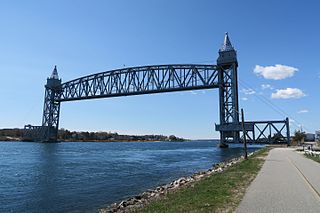
Bourne is a town in Barnstable County, Massachusetts, United States. The population was 19,754 at the 2010 census.

The Elizabeth Islands are a chain of small islands extending southwest from the southern coast of Cape Cod, Massachusetts in the United States. They are located at the outer edge of Buzzards Bay, north of Martha's Vineyard from which they are separated by Vineyard Sound, and constitute the town of Gosnold, Massachusetts in Dukes County.
Cape Cod Bay is a large bay of the Atlantic Ocean adjacent to the U.S. state of Massachusetts. Measuring 604 square miles (1,560 km2) below a line drawn from Brant Rock in Marshfield to Race Point in Provincetown, Massachusetts, it is enclosed by Cape Cod to the south and east, and Plymouth County, Massachusetts, to the west. To the north of Cape Cod Bay lie Massachusetts Bay and the Atlantic Ocean. Cape Cod Bay is the southernmost extremity of the Gulf of Maine. Cape Cod Bay is one of the bays adjacent to Massachusetts that give it the name Bay State. The others are Narragansett Bay, Buzzards Bay, and Massachusetts Bay.

Horseneck Beach State Reservation is a public recreation area comprising more than 800 acres (320 ha) on the Atlantic Ocean in the southern portion of the town of Westport, Massachusetts. The reservation is one of the state’s "most popular facilities ... welcom[ing] hundreds of thousands of visitors per year." It is managed by the Massachusetts Department of Conservation and Recreation.

Little Quittacas Pond is a lake/reservoir/pond within the towns of Lakeville and Rochester, in southeastern Massachusetts. Little Quittacas is one of the five great ponds of Southeastern Massachusetts that includes Long Pond, Assawompset Pond. Pocksha Pond, Great Quittacas and Little Quittacas Ponds. It is the location of the New Bedford Water Works. These lakes provide a source of drinking water to the city of New Bedford, the largest city in southeastern Massachusetts. Snipatuit Pond is an outlier pond that flows into Buzzards Bay, via the Mattapoisett River and is connected to Great Quittacas through Snipituit Brook. The other great ponds drain into Narragansett Bay through the Taunton River. The five ponds are the largest natural fresh watersheds in Massachusetts.

The Nasketucket River is a small river (stream) arising in Fairhaven, Massachusetts, and emptying about 3 miles downstream into Little Bay, a branch of Nasketucket Bay on Buzzards Bay.

The Wankinco River is a 7.3-mile-long (11.7 km) river in eastern Massachusetts, United States. It is a tributary of the Wareham River, which drains into Buzzards Bay.

Canapitsit Channel is a channel that runs from Cuttyhunk Harbor to the Vineyard Sound and separates Nashawena Island from Cuttyhunk Island, two of the Elizabeth Islands off Cape Cod, Massachusetts. It is one of four straits allowing maritime passage between Buzzards Bay and the Vineyard Sound. The others are Quick's Hole, Robinson's Hole and Woods Hole. Canapitsit is an Indian word meaning "current passage".

The Mattapoisett River is an 11.6-mile-long (18.7 km) river in southeastern Massachusetts, in the United States.

The Pocasset River is a small tidal river and estuary on the eastern shore of Buzzards Bay, in Bourne, Massachusetts, United States. It is located between the villages of Monument Beach and Pocasset along the western coast of Cape Cod. The river flows westward through a series of small ponds and wetlands, with a total length of about 2 miles (3.2 km).

The Weweantic River is a 17.0-mile-long (27.4 km) river in southeastern Massachusetts. Its name means "crooked" or "wandering stream" in the Wampanoag language.

Wickets Island is a 4.6 acres (1.9 ha) island located in Onset Harbor in Wareham, Massachusetts. It is located 1,100 feet (340 m) from shore.
Quick's Hole is the strait in Massachusetts' Elizabeth Islands separating Nashawena Island from Pasque Island. It is one of four straits allowing maritime passage between Buzzards Bay and the Vineyard Sound. The others are Canapitsit Channel, Robinson's Hole and Woods Hole.
Robinson's Hole is the strait in Massachusetts' Elizabeth Islands separating Naushon Island from Pasque Island. It is one of four straits allowing maritime passage between Buzzards Bay and the Vineyard Sound. The others are Canapitsit Channel, Quick's Hole and Woods Hole.
Robinson's Hole is located in the town of Gosnold.
Demarest Lloyd State Park is a public recreation area located on Buzzards Bay in the town of Dartmouth, Massachusetts. The park's 200 acres (81 ha) include both an ocean beach and seaside marshlands near the mouth of the Slocums River. The state park is managed by the Massachusetts Department of Conservation and Recreation.
The Back River is a small tidal estuary in Bourne, Massachusetts on the eastern shore of Buzzards Bay. It lies just south of the Cape Cod Canal near the village of Monument Beach. It is separated from Buzzards Bay by Phinneys Harbor. The river's length is 2.1 miles (3.4 km).
Bournedale is a village in the town of Bourne in Barnstable County, Massachusetts fronting Sagamore Beach, Buzzards Bay and the middle of the Cape Cod Canal. Along with Buzzards Bay and Sagamore Beach it is one of only three communities in Barnstable County that are north of the Cape Cod Canal. Another region in Barnstable County that are north of the Cape Cod Canal is Scusset Beach State Reservation.