Historic Denbighshire is one of thirteen traditional counties in Wales, a vice-county and a former administrative county, which covers an area in north east Wales. It is a maritime county, bounded to the north by the Irish Sea, to the east by Flintshire, Cheshire and Shropshire, to the south by Montgomeryshire and Merionethshire, and to the west by Caernarfonshire.

Sun Village is an unincorporated community and census-designated place (CDP) in Los Angeles County, California, United States. It is in the eastern Antelope Valley at an elevation of 2,723 feet (830 m). The center of Sun Village may be considered to be Palmdale Boulevard and 87th Street East as noted at the Los Angeles County Assessors office. As of the 2010 census the population of Sun Village was 11,565, up from 9,375 at the 2000 census.
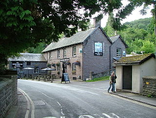
Talybont-on-Usk is a village and community in Powys, Wales, in the historic county of Brecknockshire (Breconshire). It lies on both the River Caerfanell and the Monmouthshire and Brecon Canal, about 1 mile (1.6 km) from the River Usk. In 2001 it had a population of 743, reducing to 719 at the 2011 Census. the community includes the settlements of Llansantffraed, Scethrog, Aber Village, Powys, and Pencelli.

Beddau is a large former mining village situated within the South Wales Valleys around 1.5 miles (2.4 km) from Llantrisant and 4 miles (6.4 km) from the larger town of Pontypridd in the county borough of Rhondda Cynon Taf, South Wales.

Pyle is a village and community in Bridgend county borough, Wales. This large village is served by the A48 road, and lies less than one mile from Junction 37 of the M4 motorway, and is therefore only a half-hour journey from the capital city of Wales, Cardiff. The nearest town is the seaside resort of Porthcawl. Within the Community, to the northeast of Pyle, is the adjoining settlement of Kenfig Hill, North Cornelly also adjoins Pyle and the built-up area had a population of 13,701 in 2011.
Aled was a rural district in the administrative county of Denbighshire, Wales, from 1935 to 1974.

Llangors is a small village, community and electoral ward in southern Powys, in the historic county of Brecknockshire, within the Brecon Beacons National Park.

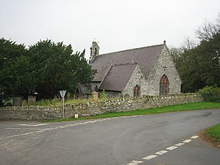
Henllan is a village and community in Denbighshire, Wales with a population of approximately 750 (OfNS/2004) and lies in the countryside, approximately 2.25 miles (3.5 km) north-west of the walled town of Denbigh. The name is Old Welsh, Hên-llan, meaning "old church-enclosure". The population had increased to 862 at the 2011 census.

The LL postcode area, also known as the Llandudno postcode area, is a group of 67 postcode districts, within 62 post towns. These cover the majority of north Wales, plus a very small part of west Wales and the English county of Shropshire. The districts start at LL11 so as to avoid confusion with Liverpool postcodes.
Church Village is a large village in the historic parish and community of Llantwit Fardre, located within the Taff Ely district of the County Borough of Rhondda Cynon Taf in Wales. The village is centrally located being around 4 miles from the local principal towns of Llantrisant to the southwest and Pontypridd to the north and is situated around 10 miles northwest of Cardiff city centre.

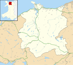
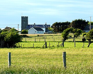
Llansannan is a rural village and community in Conwy County Borough, Wales. It lies on the bank of the River Aled and is about 8 miles to the south of Abergele and 9 miles (14 km) to the west of Denbigh. The population was 1,291 in 2001, with 67% able to speak Welsh. The figures for the 2011 census were: population 1,335 with 63% able to speak Welsh. The community includes the hamlets of Bylchau, Rhydgaled and Y Groes, and the lake Llyn Aled and reservoir Aled Isaf on Mynydd Hiraethog. Llansannan is in the traditional county of Denbighshire.

Llanfair Talhaiarn, abbreviated to Llanfair TH, is a village and community approximately 5 miles (8.0 km) south of Abergele in Conwy county borough, Wales. Until 1974 it was included in Denbighshire.
Trewern is a small village, community and electoral ward in Montgomeryshire, Powys, Wales. The community includes the villages of Buttington and Middletown, situated 4.5 miles (7 km) northeast of Welshpool, 14.5 miles (23.5 km) west of Shrewsbury and 1 mile (1.6 km) west of the Wales-England border.

Llangunllo is a village and community in central Powys, Wales, located about 5 miles west of Knighton. It is named after St Cynllo. The population of the community at the 2011 census was 369.
Llansantffraid or Llansantffraed is a small rural village and community and practically merged with the village of Llanon just west of the main A487 Coastal Road between Aberaeron and Aberystwyth, about eleven miles from Aberystwyth. The population in 2001 was 1,241, declining to 1,212 at the 2011 census.

Maescar is a community in the county of Powys, Wales, and is 35.4 miles (56.9 km) from Cardiff and 148.7 miles (239.3 km) from London. It is in the historic county of Brecknockshire.

The River Aled, a small river near Conwy County Borough, flows into River Elwy.
Troedyraur is a small village, wider rural community and electoral ward in Ceredigion, Wales. The community consisting of several small villages, the population as of the 2011 UK Census was 1,310.
The 2017 Conwy Council election took place on 4 May 2017 to elect members of Conwy County Borough Council in Wales. It was on the same day as other 2017 Welsh local elections. The previous elections took place on 3 May 2012.

The 2008 Conwy Council election took place on 1 May 2008 to elect members of Conwy County Borough Council in Wales. It was on the same day as other 2008 United Kingdom local elections. The previous elections took place on 10 June 2004 and the following election took place on 3 May 2012.