Route 710, consisting of the non-contiguous segments of State Route 710 and Interstate 710 (I-710), is a major north–south state highway and auxiliary Interstate Highway in the Los Angeles metropolitan area of the U.S. state of California. Also called the Los Angeles River Freeway prior to November 18, 1954, the highway was initially planned to connect Long Beach and Pasadena, but a gap in the route exists from Alhambra to Pasadena through South Pasadena due to community opposition to its construction.
State Route 57 (SR 57), also known as the Orange Freeway for most of its length, is a north–south state highway in the Greater Los Angeles Area of California. It connects the interchange of Interstate 5 (I-5) and SR 22 near downtown Orange, locally known as the Orange Crush, to the Glendora Curve interchange with I-210 and SR 210 in Glendora. The highway provides a route across several spurs of the Peninsular Ranges, linking the Los Angeles Basin with the Pomona Valley and San Gabriel Valley.

The Pomona Valley is located in the Greater Los Angeles Area between the San Gabriel Valley and San Bernardino Valley in Southern California. The valley is approximately 30 miles east of downtown Los Angeles, which can often be seen from nearby foothills. It ranges from the city of San Dimas from the far west to Rancho Cucamonga to the far east portion of the valley. The alluvial valley is formed by the Santa Ana River and its tributaries.
The Cucamonga Valley is a region of southwestern San Bernardino County and northwestern Riverside County, in southern California. It is located below the San Gabriel Mountains in the Inland Empire region.

State Route 138 is an east–west state highway in the U.S. state of California that generally follows the northern foothills of the San Gabriel Mountains and the western Mojave Desert. The scenic highway begins in the west at its junction with Interstate 5 located south of Gorman in the Sierra Pelona Mountains, continues eastward through the Antelope Valley and Cajon Pass, to its junction with State Route 18 in the east, located in the San Bernardino Mountains south of Crestline.

State Route 238 is a north–south state highway in the U.S. state of California. The route is a divided multilane surface highway in the southeastern part of the San Francisco Bay Area. SR 238 connects Interstate 680 in Fremont with Interstate 580 in Castro Valley.

State Route 60 is an east-west state highway in the U.S. state of California. It serves the cities and communities on the eastern side of the Los Angeles metropolitan area and runs along the south side of the San Gabriel Valley. It functions as a bypass route of Interstate 10 (I-10) through the area between the East Los Angeles Interchange in Los Angeles and Beaumont. SR 60 provides a route across several spurs of the Peninsular Ranges, linking the Los Angeles Basin with the Pomona Valley and San Gabriel Valley. The highway also overlaps at State Route 57 and Interstate 215.

State Route 123 is a state highway in the U.S. state of California in the San Francisco Bay Area. Named San Pablo Avenue for virtually its entire length, SR 123 is a major north–south state highway along the flats of the urban East Bay. Route 123 runs about 7.39 miles (11.9 km) between Interstate 580 in Oakland in the south and Interstate 80 in Richmond in the north. San Pablo Avenue itself, a portion of Historic US 40, continues well past these termini, south to Downtown Oakland and north to Crockett, but without the Route 123 designation.
State Route 2 (SR 2) is a state highway in the U.S. state of California that runs from the Los Angeles Basin and through the San Gabriel Mountains to the edge of the Victor Valley in the Mojave Desert. Officially, it begins at the intersection of Centinela Avenue in the City of Los Angeles limits adjacent to the city of Santa Monica and extends all the way to SR 138 east of Wrightwood. The highway currently is divided into three segments, and it briefly runs concurrently with U.S. Route 101 (US 101) and Interstate 210 (I-210) to connect the segments. The western section of the highway is an old routing of US 66; the eastern portion is known as the Angeles Crest Highway, while the middle section is known as the Glendale Freeway along with multiple surface streets around US 101.

State Route 18 is a state highway in the U.S. state of California. It serves as a primary route into the San Bernardino Mountains, both from the Riverside–San Bernardino metropolitan area from the south and the Mojave Desert from the north. SR 18 runs from State Route 210 in San Bernardino to State Route 138 in Llano. It has two discontinuities: one in Big Bear Lake, the other in Victorville.
Route 210, consisting of State Route 210 (SR 210) and Interstate 210 (I-210), is a state and auxiliary Interstate Highway in the Los Angeles metropolitan area of the U.S. state of California. Designated as the Foothill Freeway for its entire length, it runs from I-5 in the Sylmar district of Los Angeles near the Santa Clarita city limits east to I-10 in Redlands. The western segment from I-5 to SR 57 in Glendora is signed as I-210, while the eastern segment to I-10 in Redlands is signed as SR 210.

State Route 71 is a 15-mile (24 km) state highway in the U.S. state of California. Serving Riverside, San Bernardino, and Los Angeles counties, it runs from SR 91 in Corona to the Interstate 10/SR 57/Kellogg Interchange at the Pomona–San Dimas boundary. The segment from SR 91 to SR 83 in Chino Hills is called the Corona Freeway, formerly the Corona Expressway and before then the Temescal Freeway. SR 71 is designated as the Chino Valley Freeway between SR 83 and the Kellogg Interchange.

State Route 19, also known as Lakewood Boulevard and Rosemead Boulevard, is a state highway in the Los Angeles area of the U.S. state of California. The route is a north–south four-to-six lane suburban roadway, lying between the Long Beach Freeway (I-710) and San Gabriel River Freeway (I-605), and connecting the eastern parts of Long Beach and Pasadena via the Whittier Narrows. Since 1998, several pieces have been relinquished to local governments, and more transfers are authorized by state law. The portion of SR 19 north of the Whittier Narrows is officially State Route 164, once planned to be upgraded as the Rio Hondo Freeway, but has always been signed as part of SR 19.

State Route 142, also known as Carbon Canyon Road for most of its length, is a state highway in the U.S. state of California that connects Brea in Orange County with Chino Hills in San Bernardino County. The eastern portion of the route is known as Chino Hills Parkway.

State Route 83, also or primarily known as Euclid Avenue, is a state highway and city street in the U.S. state of California. Officially, SR 83 runs from the Chino Valley Freeway in Chino Hills north to the San Bernardino Freeway in Upland. Euclid Avenue then continues north through Upland to the unincorporated community of San Antonio Heights.

State Route 185 is a state highway in the San Francisco Bay Area of the U.S. state of California. It runs along sections of Mission Boulevard in Hayward, East 14th Street in San Leandro and International Boulevard in Oakland. At its south end, SR 185 connects with State Routes 92 and 238 in Hayward. At the north end of SR 185 at International Boulevard and 42nd Avenue, the short State Route 77 heads southwest to Interstate 880.
Foothill Boulevard is a major road in the city and county of Los Angeles, as well as an arterial road in the city and county of San Bernardino, stretching well over 60 miles (97 km) in length, with some notable breaks along the route. Like its name implies, Foothill Boulevard runs across the foothills of the San Gabriel and San Bernardino Mountains.
Interstate 10 (I-10) is a transcontinental Interstate Highway in the United States, stretching from Santa Monica, California, on the Pacific Ocean, to Jacksonville, Florida. The segment of I-10 in California runs east from Santa Monica through Los Angeles, San Bernardino, and Palm Springs before crossing into the state of Arizona. In the Greater Los Angeles area, it is known as the Santa Monica Freeway and the San Bernardino Freeway, linked by a short concurrency on I-5 at the East Los Angeles Interchange. I-10 also has parts designated as either the Rosa Parks Freeway, the Redlands Freeway, or the Christopher Columbus Transcontinental Highway.
Route 15, consisting of the contiguous segments of State Route 15 and Interstate 15 (I-15), is a major north–south state highway and Interstate Highway in the U.S. state of California, connecting San Bernardino, Riverside, and San Diego Counties. The route consists of the southernmost 289.24 miles (465.49 km) of I-15, which extends north through Nevada, Arizona, Utah, Idaho, and Montana to the Canada–US border. It is a major thoroughfare for traffic between San Diego and the Inland Empire, as well as between Southern California, Las Vegas, Nevada, and the Intermountain West.
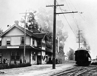
The Upland–San Bernardino Line was an interurban line operated by the Pacific Electric Railway between Downtown Los Angeles and San Bernardino, California. This line also had shorter service that terminated before the end of the line at Baldwin Park, Covina, and San Dimas. Though service along this line in its entirety was discontinued in November 1941, it stands as the fourth-longest rapid transit line in American history, after the Sacramento Northern Chico and Colusa services, and the Pacific Electric's own Riverside–Rialto Line.

