Westfield-Barnes Regional Airport is a public/military airport in Hampden County, Massachusetts, United States. It is owned by the City of Westfield and is three miles (6 km) north of it. The airport is northwest of the larger city of Springfield. Formerly known as Barnes Municipal Airport, it is included in the National Plan of Integrated Airport Systems for 2011–2015, which categorized it as a general aviation facility. Westfield-Barnes is one of Massachusetts' largest airports with a strong flight training, general aviation, and military presence.
Metropolitan Airport was a privately owned, private-use airport located in the town of Palmer, in Hampden County, Massachusetts, USA. It has one runway, averaged 22 flights per day, and had approximately 24 aircraft based on its field.

Cairns Army Airfield is a military airport forming a part of Fort Rucker, in Dale County, Alabama, USA and is owned by the United States Army. The airfield is south of the town of Daleville, which sits between it and the main post.

Portland Downtown Heliport, is a public heliport located in the Old Town Chinatown neighborhood in the Northwest section of the city of Portland, Multnomah County, Oregon, USA. It occupies the roof of a 1989 parking garage located at the intersection of NW Naito Parkway and NW Davis Street, not far from the Steel Bridge over the Willamette River.

McNary ARNG Field Heliport, is a military heliport located two miles (3 km) southeast of the city of Salem in Marion County, Oregon, USA. The heliport is located on the north east corner of Salem Municipal Airport. The heliport serves as the primary base of activity for the Oregon National Guard Army Aviation Support Facility.
Camp Rilea Heliport, is a military heliport located three miles (4.8 km) south of the city of Warrenton in Clatsop County, Oregon, USA.
The Joint Base Cape Cod is a joint base created by the Commonwealth of Massachusetts and the United States War Department in 1935. Governor James Curley signed the state bill to allocate and purchase land for a military facility, and establishing a formal commission to manage this new state military property and personnel. After 22,000 acres of land was secured in Cape Cod, the Massachusetts National Guard began erecting tents and a basic training program in the following year. Formerly the Massachusetts Military Reservation, it was renamed in 2013 to Joint Base Cape Cod.

Hanchey Army Heliport is a military heliport serving Fort Rucker in Dale County, Alabama, United States. Owned by the United States Army, it is located 6 NM (11 km) south of the city of Ozark.
Roberts Army Heliport is a U.S. Army heliport at Camp Roberts in extreme southern Monterey County, California, United States. It is located just off U.S. Route 101, four nautical miles northwest of the central business district of San Miguel, about halfway between it and the tiny community of Bradley in southern Monterey County. Roberts AHP has one helipad designated H1 with a 2,740 x 100 ft asphalt surface.

Rentschler Heliport is a private heliport for the exclusive use of United Technologies Corporation, located 2 miles southeast of East Hartford, Connecticut.

Keystone Airpark, also known as Keystone Heights Airport, is a public use airport located three nautical miles (6 km) north of the central business district of Keystone Heights, a town in Clay County, Florida, United States. The airport is situated in Clay County and Bradford County.
Sabre Army Heliport is a military use heliport located at Fort Campbell, seven nautical miles (13 km) northwest of the central business district of Clarksville, in Montgomery County, Tennessee, United States. Owned by the United States Army, it has one runway designated 4/22 with a concrete surface measuring 4,451 by 109 feet.
Lowe Army Heliport is a military heliport serving Fort Rucker in Dale County, Alabama, United States. Owned by the United States Army, it is located 8 nautical miles (15 km) southwest of the city of Ozark. World's busiest heliport launching over 100 flights daily.

Haverstraw Heliport is a privately owned, public use heliport located one nautical mile (2 km) east of Haverstraw, a village in the Town of Haverstraw, Rockland County, New York, United States.
Snow Airport is a privately owned, private-use airport located in the town of Ipswich, in Essex County, Massachusetts, USA. It has one runway, 4/22.
Ware Airport is a privately owned, private-use airport located in the town of Ware, in Worcester County, Massachusetts, USA. It has one runway, N/S.
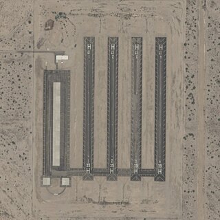
Picacho Army National Guard Heliport, also known as Picacho Stagefield Heliport formally Marana Auxiliary Army Airfield No. 1 is an Arizona Army National Guard towered training field 4 miles southeast of Picacho, Arizona. The Airport is owned and operated by the United States Army. The field serves as a training facility for the Western Army National Guard Aviation Training Site based out of Pinal Airpark.

Ferris Red Oak Muni Heliport is a city-owned public heliport in Ellis County, Texas, United States, serving the cities of Ferris, Texas and Red Oak, Texas. The heliport has no IATA or ICAO designation. The facility is alternately known as the Ferris Red Oak Municipal Heliport.
Dallas CBD Vertiport is a city-owned public heliport/vertiport in the city of Dallas, Dallas County, Texas, United States. The facility is located at the south end of the Kay Bailey Hutchison Convention Center in the Dallas Central Business District, and is claimed to be the world's largest elevated heliport/vertiport.
DeSoto Heliport is a city-owned public heliport in DeSoto, Dallas County, Texas, United States, located approximately 3 nautical miles (5.6 km) north of the central business district. The heliport has no IATA or ICAO designation.