Canaman, Camarines Sur

Last updated
Canaman
Municipality of Canaman
Canaman Church 002.jpg
Canaman Camarines Sur.png
Seal
Nicknames: 
Citadel of Bicol Culture
Birthplace of Tancong Vaca Guerilla Unit
Motto(s): 
"Bangon Canaman!" ("Rise Canaman!")
Ph locator camarines sur canaman.png
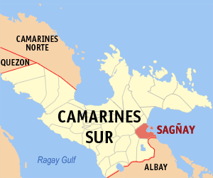
Map of Camarines Sur with Canaman highlighted
Philippines location map (square).svg
Red pog.svg
Canaman
Location within the Philippines
Coordinates: 13°39′N123°10′E / 13.65°N 123.17°E / 13.65; 123.17 Coordinates: 13°39′N123°10′E / 13.65°N 123.17°E / 13.65; 123.17
Country Flag of the Philippines.svg  Philippines
Region Bicol Region (Region V)
Province Camarines Sur
District 3rd district
Founded1583
Barangays 24 (see Barangays)
Government
[1]
  Type Sangguniang Bayan
   Mayor Nelson M. Legaspi
   Vice Mayor Venancio B. Regulado
  CongressmanGabriel H. Bordado Jr.
  Electorate20,446 voters (2019)
Area
[2]
  Total43.27 km2 (16.71 sq mi)
Elevation
5 m (16 ft)
Population
 (2015 census) [3]
  Total34,210
  Density790/km2 (2,000/sq mi)
Time zone UTC+8 (PST)
ZIP code
4402
PSGC
IDD : area code +63(0)54
Climate type tropical rainforest climate
Income class 4th municipal income class
Revenue (₱)79.5 million (2016)
Poverty incidence 24.21 (2012) [4]
Native languagesCentral Bikol
Tagalog

Canaman, officially the Municipality of Canaman, is a 4th class municipality in the province of Camarines Sur, Philippines. According to the 2015 census, it has a population of 34,210 people. [3]

Camarines Sur Province in Bicol Region, Philippines

Camarines Sur is a province located in the Bicol Region in Luzon of the Philippines. Its capital is Pili and the province borders Camarines Norte and Quezon to the northwest, and Albay to the south. To the east lies the island province of Catanduanes across the Maqueda Channel.

Philippines Republic in Southeast Asia

The Philippines, officially the Republic of the Philippines, is an archipelagic country in Southeast Asia. Situated in the western Pacific Ocean, it consists of about 7,641 islands that are categorized broadly under three main geographical divisions from north to south: Luzon, Visayas and Mindanao. The capital city of the Philippines is Manila and the most populous city is Quezon City, both part of Metro Manila. Bounded by the South China Sea on the west, the Philippine Sea on the east and the Celebes Sea on the southwest, the Philippines shares maritime borders with Taiwan to the north, Japan to the northeast, Vietnam to the west, Palau to the east, and Malaysia and Indonesia to the south.

Contents

A landlocked municipality centrally located in the province of Camarines Sur, it is bounded on the north by Magarao, on the south by Gainza and Camaligan, on the east by Naga City, and on the south-west by the broad Bicol River. From north to south it is 6 kilometres (3.7 mi) long, and 14 kilometres (8.7 mi) wide from east to west.

Naga, Camarines Sur Independent Component City in Bicol Region, Philippines

Naga, officially the City of Naga, or simply Naga City, is a 2nd class independent component city in the Bicol Region, Philippines. According to the 2015 census, it has a population of 196,003 people.

Bicol River river in the Philippines

The Bicol River is the eighth largest river in the Philippines in terms of drainage basin size with an estimated catchment area of 3,770 square kilometres (1,460 sq mi). The river drains the southwestern part of the island of Luzon and passes through Camarines Sur province in the Bicol Region.

Etymology

The area that is now Canaman used to very thickly forested. According to Fr. Frank Lynch, S.J., who said that Canaman is the purest among Bicol dialects: “The name Canaman is locally said to be derived from the root kana, meaning "building materials". The suffix -man is taken as a locative, the name thus indicating “place where there are building materials”. [5]

History

Spanish colonization in Canaman began around the 1580s when some Nueva Caceres-based missionaries apparently on their way back from gospel work in either the visita of Quipayo (now Calabanga) or San Gabriel (now a barangay of Pamplona), got their bearings confused and, thinking they were turning eastward from the Bicol River to its Naga tributary, instead entered the Canaman creek which at the time was still a deep and fast flowing stream. They continued paddling until they ended up at a native settlement in what is now the barangay of Poro.

In June 1583, the place was organized into a parish, administered by Fray Pedro Matias de Andrade, a Franciscan who later became the fifth Bishop of Diocese of Caceres. In the 1590s, its church was constructed, which was rebuilt in 1669. [5] The patron saint at that time was San Roque, whose image, said to have come all the way from Spain was met at its arrival by the people of Canaman in the shores of Pasacao.

Philippine-American War

In 1900, after militant Canamanons heard that the Americans were closing in, they burned the church to the ground in an act of self-immolation to prevent desecration of the church at the hands of the new imperialists. [5] The burning was a deliberate and intentional act: the arsonists even gathered and piled on top of the church’s expensive organ dry grass and big tree branches to which they touched the match, to make certain that the fire consumed all combustible parts of the 231-year-old building and its interiors.

Self-immolation is the act of killing oneself for political or religious reasons, particularly by burning. It is often used as an extreme form of protest or in acts of martyrdom. It has a centuries-long recognition as the most extreme form of protest achieved by humankind.

Desecration is the act of depriving something of its sacred character, or the disrespectful, contemptuous, or destructive treatment of that which is held to be sacred or holy by a group or individual.

In 1902, during the provincial governorship of Captain George Curry, the Municipality of Canaman and its office of the presidente municipal was dissolved and lost its independent existence. [5] Canaman was annexed to Nueva Caceres (now Naga City), though some barrio were attached to Magarao and Canaman’s top position of presidente municipal was downgraded to concejal encargado.

Public educational system reached Canaman in 1903 with the arrival of a certain Miss Long, an American schoolteacher. She opened the first school now known as Canaman Central School in Dinaga, at the house of Don Basilio Severo (at the spot where the Facoma building stands at present) which the government rented.

In 1909, Canaman regained its status as an independent municipality, when it was separated from Nueva Caceres by an act of the First Philippine Legislature. This was mainly due to the efforts of Tomas Arejola, the representative of the first district of Ambos Camarines to the first legislature. [5]

World War II

On March 8, 1942, three months after Japanese Imperial Forces landed in Legaspi and Naga City, the Tangcong Vaca Guerilla Unit (TVGU) was organized in Barangay San Nicolas, with Juan Miranda as the Commanding Officer, Leon Aureus as the Executive Officer and Elias Madrid as the Finance Officer. [5] Among the numerous taga-Canaman who joined-up soon afterwards either in the unit’s intelligence or combat components were Jose and Antonio Madrid, Mamerto Sibulo, Andres Fortaleza, Marcos Severo, Damaso Avenilla, Federico Crescini, Nicolas Vargas, Venancio Begino, Eugenio Ragodon, Juan Pachica, Santiago Amaro, Jose Gervas, Pedro Angeles, Aproniano Lopez, Andres Alzate, Modesto Sanchez, Blas Alcantara, Andres Aguilar, Florencio Frondozo, Alfredo de la Torre and Flaviano Estrada.

In April 1945, Canaman was liberated by the 5th, 52nd, 53rd, 55th, 56th and 57th Infantry Divisions of the Philippine Commonwealth Army and the Bicolano guerrilla resistance fighters of the Tangcong Vaca Guerrilla Unit (TVGU).

Climate

Climate data for Canaman, Camarines Sur
MonthJanFebMarAprMayJunJulAugSepOctNovDecYear
Average high °C (°F)32
(90)
31
(88)
34
(93)
36
(97)
37
(99)
37
(99)
36
(97)
34
(93)
35
(95)
34
(93)
33
(91)
32
(90)
34
(94)
Average low °C (°F)27
(81)
27
(81)
29
(84)
31
(88)
32
(90)
32
(90)
31
(88)
30
(86)
30
(86)
29
(84)
28
(82)
28
(82)
30
(85)
Average precipitation mm (inches)39.34
(1.55)
68.7
(2.70)
26.73
(1.05)
66.19
(2.61)
84.49
(3.33)
178.89
(7.04)
244.27
(9.62)
188.3
(7.41)
160.98
(6.34)
445
(17.5)
135.5
(5.33)
367.8
(14.48)
2,006.19
(78.96)
Average rainy days161813152328302426272529274
Source: World Weather Online [6]

Barangays

Canaman is politically subdivided into 24 barangays.

Demographics

Population census of Canaman
YearPop.±% p.a.
1918 3,710    
1939 5,592+1.97%
1948 9,032+5.47%
1960 8,988−0.04%
1970 12,422+3.28%
1975 14,522+3.18%
1980 15,787+1.68%
1990 20,298+2.55%
1995 22,732+2.14%
2000 27,719+4.34%
2007 31,583+1.82%
2010 32,390+0.92%
2015 34,210+1.05%
Source: Philippine Statistics Authority [3] [7] [8] [9]

In the 2015 census, the population of Canaman was 34,210 people, [3] with a density of 790 inhabitants per square kilometre or 2,000 inhabitants per square mile.

Economy

Farming, fishing, and small business are the primary sources of employment and household income. [10]

While most of the people's market activities are done in Naga City, Canaman has a public market and a privately owned "talipapa". Two agro-industrial establishments are found in Canaman: the poultry feeds and palay.

Various types of cottage industries like handicraft, furniture, fan making (made of anahaw), ragiwdiw and nipa shingles are conducted in this town. [10]

In 1998, it was recorded that agricultural workers made up only 27.3% of the work force while 70.8% were engaged in non-agricultural activities. 88.38% of the total land area is devoted to agriculture.

In 2014, Canaman Dragon Boat Camp was launched in the village of Mangayawan along the Bicol River which serves as the turf of the Bicol River Hot Paddlers. [11]

Culture

Every month of May, the community honors the Holy Cross through Lagaylay, a tradition which began over a century ago. For nine nights, women dance on the church or a chapel's square while chanting prayers to the Cross.

Transportation

Most of the roads and main streets in the poblacion (urban barangays) are concrete with few earth and gravel roads, 4 can be reached only through water transportation while 11 can be reached either through water transportation and/or by land transportation.

Related Research Articles

Tiwi, Albay Municipality of the Philippines in the province of Albay

Tiwi,, is a 1st class municipality in the Province of Albay, Philippines. According to the 2015 census, it has a population of 53,120 people.

San Vicente, Camarines Norte Municipality in Bicol Region, Philippines

San Vicente, officially the Municipality of San Vicente, is a 5th class municipality in the province of Camarines Norte, Philippines. According to the 2015 census, it has a population of 10,396 people.

Baao, Camarines Sur Municipality in Bicol Region, Philippines

Baao,, officially the Municipality of Baao, is a 3rd class municipality in the province of Camarines Sur, Philippines. According to the 2015 census, it has a population of 58,849 people.

Bombon, Camarines Sur Municipality in Bicol Region, Philippines

Bombon, officially the Municipality of Bombon, is a 5th class municipality in the province of Camarines Sur, Philippines. According to the 2015 census, it has a population of 16,512 people.

Bula, Camarines Sur Municipality in Bicol Region, Philippines

Bula,, officially the Municipality of Bula, is a 2nd class municipality in the province of Camarines Sur, Philippines. According to the 2015 census, it has a population of 69,430 people.

Goa, Camarines Sur Municipality in Bicol Region, Philippines

Goa, officially the Municipality of Goa, is a 2nd class municipality in the province of Camarines Sur, Philippines. According to the 2015 census, it has a population of 63,308 people.

Lagonoy, Camarines Sur Municipality in Bicol Region, Philippines

Lagonoy, officially the Municipality of Lagonoy, is a 2nd class municipality in the province of Camarines Sur, Philippines. According to the 2015 census, it has a population of 55,465 people.

Libmanan, Camarines Sur Municipality in Bicol Region, Philippines

Libmanan, officially the Municipality of Libmanan, is a 1st class municipality in the province of Camarines Sur, Philippines. According to the 2015 census, it has a population of 108,716 people. The town is home to the Morales Ruins, a 1937 architectural Art Deco masterpiece in the heart of the historic town. The Art Deco building is reportedly designed by a Filipino national artist.

Lupi, Camarines Sur Municipality in Bicol Region, Philippines

Lupi, officially the Municipality of Lupi, is a 3rd class municipality in the province of Camarines Sur, Philippines. According to the 2015 census, it has a population of 32,167 people.

Magarao Municipality in Bicol Region, Philippines

Magarao, officially the Municipality of Magarao, is a 4th class municipality in the province of Camarines Sur, Philippines. According to the 2015 census, it has a population of 25,694 people.

Milaor Municipality in Bicol Region, Philippines

Milaor, officially the Municipality of Milaor, is a 4th class municipality in the province of Camarines Sur, Philippines. According to the 2015 census, it has a population of 31,150 people.

Minalabac, Camarines Sur Municipality in Bicol Region, Philippines

Minalabac, officially the Municipality of Minalabac, is a 3rd class municipality in the province of Camarines Sur, Philippines. According to the 2015 census, it has a population of 52,390 people.

Ocampo, Camarines Sur Municipality in Bicol Region, Philippines

Ocampo, officially the Municipality of Ocampo, is a 3rd class municipality in the province of Camarines Sur, Philippines.

Pasacao, Camarines Sur Municipality in Bicol Region, Philippines

Pasacao, officially the Municipality of Pasacao, is a 3rd class municipality in the province of Camarines Sur, Philippines. According to the 2015 census, it has a population of 49,035 people.

Pili, Camarines Sur Municipality in Bicol Region, Philippines

Pili,, officially the Municipality of Pili, is a 1st class municipality and the capital town of the province of Camarines Sur, Philippines. According to the 2015 census, it has a population of 89,545 people.

Sagñay Municipality of the Philippines in the province of Camarines Sur

Sagñay, [ˈsaŋaj], officially the Municipality of Sagñay, is a 4th class municipality in the province of Camarines Sur, Philippines. According to the 2015 census, it has a population of 34,546 people.

Siruma, Camarines Sur Municipality in Bicol Region, Philippines

Siruma, officially the Municipality of Siruma, is a 4th class municipality in the province of Camarines Sur, Philippines. According to the 2015 census, it has a population of 17,764 people.

Tinambac, Camarines Sur Municipality in Bicol Region, Philippines

Tinambac, officially the Municipality of Tinambac, is a 1st class municipality in the province of Camarines Sur, Philippines. According to the 2015 census, it has a population of 67,572 people.

References

  1. "Municipality". Quezon City, Philippines: Department of the Interior and Local Government. Retrieved 31 May 2013.
  2. "Province: Camarines Sur". PSGC Interactive. Quezon City, Philippines: Philippine Statistics Authority . Retrieved 12 November 2016.
  3. 1 2 3 4 Census of Population (2015). "Region V (Bicol Region)". Total Population by Province, City, Municipality and Barangay. PSA . Retrieved 20 June 2016.
  4. "PSA Releases the 2012 Municipal and City Level Poverty Estimates". Quezon City, Philippines: Philippine Statistics Authority. Archived from the original on 28 January 2017. Retrieved 28 January 2017.
  5. 1 2 3 4 5 6 "History". About Canaman. Local Government Unit of Canaman. Retrieved 4 January 2013.
  6. "Canaman, Camarines Sur: Average Temperatures and Rainfall". World Weather Online. Retrieved 29 October 2017.
  7. Census of Population and Housing (2010). "Region V (Bicol Region)". Total Population by Province, City, Municipality and Barangay. NSO . Retrieved 29 June 2016.
  8. Censuses of Population (1903–2007). "Region V (Bicol Region)". Table 1. Population Enumerated in Various Censuses by Province/Highly Urbanized City: 1903 to 2007. NSO.
  9. "Province of Camarines Sur". Municipality Population Data. Local Water Utilities Administration Research Division. Retrieved 17 December 2016.
  10. 1 2 "Economy". About Canaman. Local Government Unit of Canaman. Retrieved 4 January 2013.
  11. Canaman holds first Dragon Boat race Bicol Mail