
Gloucester Island is a national park in Queensland, Australia, 950 km northwest of Brisbane. It is visible from the town of Bowen. The island was seen and erroneously named "Cape Gloucester" by British explorer James Cook in 1770. The name "Cape Gloucester" has been used informally for areas on or near Gloucester Island.

New Britain is the largest island in the Bismarck Archipelago of Papua New Guinea. It is separated from the island of New Guinea by the Dampier and Vitiaz Straits and from New Ireland by St. George's Channel. The main towns of New Britain are Rabaul/Kokopo and Kimbe. The island is roughly the size of Taiwan. While the island was part of German New Guinea, it was named Neupommern.

The Torres Strait is a strait which lies between Australia and the Melanesian island of New Guinea. It is approximately 150 km (93 mi) wide at its narrowest extent. To the south is Cape York Peninsula, the northernmost extremity of the Australian mainland. To the north is the Western Province of Papua New Guinea. It is named after navigator Luís Vaz de Torres, who passed through the Strait in 1606.
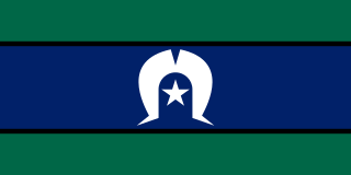
The Torres Strait Islands are a group of at least 274 small islands which lie in Torres Strait, the waterway separating far northern continental Australia's Cape York Peninsula and the island of New Guinea.

The Territory of Papua comprised the southeastern quarter of the island of New Guinea from 1883 to 1975. In 1883, the Government of Queensland annexed this territory for the British Empire. The United Kingdom Government refused to ratify the annexation but in 1884 a Protectorate was proclaimed over the territory, then called "British New Guinea". There is a certain ambiguity about the exact date on which the entire territory was annexed by the British. The Papua Act 1905 recites that this happened "on or about" 4 September 1888. On 18 March 1902, the Territory was placed under the authority of the Commonwealth of Australia. Resolutions of acceptance were passed by the Commonwealth Parliament, who accepted the territory under the name of Papua.
Boigu Island is the most northerly inhabited island of Queensland and of Australia. It is part of the top-western group of the Torres Strait Islands, which lie in the Torres Strait separating Cape York Peninsula from the island of New Guinea. The mainland of Papua New Guinea is only 6 kilometres (3.7 mi) away from Boigu. Boigu has an area of 89.6 square kilometres (34.6 sq mi). Boigu is also the name of the town and Boigu Island is the name of the locality on the island within the Torres Strait Island Region.

Normanby Island is a volcanic 1,000-square-kilometre (390 sq mi), L-shaped island, the southern most island in the D'Entrecasteaux Islands group. It is part of Milne Bay Province, Papua New Guinea.

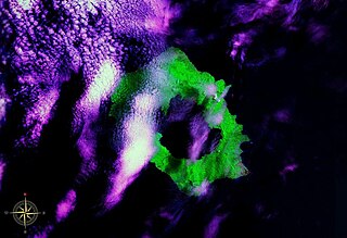
Langila is one of the most active volcanoes of New Britain, Papua New Guinea. It consists of four overlapping volcanic cones on the eastern flank of an older extinct volcano, Talawe. Talawe is the largest volcano in Cape Gloucester. There have been dozens of recorded eruptions since the 19th century from three separate volcanic craters at the summit of Langila. The most recent eruptive cycle of Langila began in August 2006 and continued into early 2007. Volcanic activity at Langila consists of Strombo-Vulcanian and Vulcanian eruptions and lava flows. Langila is one of the most active volcanoes in the Bismark archipelago. The smallest crater is crater number 3.

Adrian Lam is the head coach of the Wigan Warriors in the Super League. He played rugby league and represented the PNG Kumuls (#163), Queensland State of Origin team, Sydney Roosters and Wigan Warriors.
Long Island is a volcanic island in Papua New Guinea. It is located north of the island of New Guinea, separated from it by the Vitiaz Strait.

Papuan sheath-tailed bat – Saccolaimus mixtus – is a species of the Emballonuridae family which occurs at Cape York peninsula and New Guinea. The poorly known species hunts in open forests for night flying insects.
Tony Puana is a Papua New Guinea politician. He was a member of the National Parliament of Papua New Guinea since from 2007 to 2012, representing the Kandrian-Gloucester Open electorate.

Cyclone Guba was the most recent tropical cyclone to form in the Port Moresby area of responsibility. The storm resulted in 149 fatalities and severe damage across southeastern Papua New Guinea in November 2007. The firstly-named cyclone of the 2007–08 Australian region cyclone season, Guba formed on 13 November 2007 close to the island of New Guinea, and reached tropical cyclone intensity the next day by the Tropical Cyclone Warning Centre (TCWC) in Brisbane, with the TCWC in Port Moresby assigning the name Guba. It meandered in the northern Coral Sea for the next week, strengthening to a Category 3 severe tropical cyclone on 16 November. It posed a threat to the Australian Cape York Peninsula, but remained offshore, and finally dissipated on 20 November.
No. 13 Signals Unit RAAF was a Royal Australian Air Force signals unit during World War II.

New Guinea is a large island separated by a shallow sea from the rest of the Australian continent. It is the world's second-largest island, after Greenland, covering a land area of 785,753 km2 (303,381 sq mi), and the largest wholly or partly within the Southern Hemisphere and Oceania.
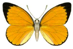
Delias aruna, the golden Jezebel, is a butterfly in the family Pieridae. It is found in Queensland, Irian Jaya, Maluku, Papua New Guinea and several surrounding islands.

Arawe is an island in Papua New Guinea, located on the southern coast of New Britain about 100 kilometres (62 mi) from Cape Gloucester. It is also the name given to the island's surrounding area, which is also known as Cape Merkus. A small harbour known as Arawe Harbour provides an anchorage. The Battle of Arawe was fought for control of the region during World War II.

The Papua New Guinea Hunters are a professional rugby league football club based in Papua New Guinea. They were formed in 2013 and currently compete in the Queensland Rugby League's Intrust Super Cup, a second tier of rugby league in Australia. The Hunters are the second Papua New Guinean side to enter the Intrust Super Cup following the Port Moresby Vipers who competed for two seasons in 1996 and 1997. Every Hunters match is shown live on national free-to-air television. The Hunters' home ground is the National Football Stadium in Port Moresby and their team colours are red, black and gold. The Hunters won the Intrust Super Cup in Queensland in 2017.

The black-eared catbird is a species of bowerbird (Ptilonorhynchidae) which can be found northern Queensland and New Guinea, including its surrounding islands. They are named after their cat-like wails and black ear spot. It is described by its Latin name: ailur-cat, oidos-singing, melas-black and otus-ear.
