
Cape Breton Island is an island on the Atlantic coast of North America and part of the province of Nova Scotia, Canada.

U.S. Route 9 is a north–south United States highway in the states of Delaware, New Jersey, and New York in the United States. It is one of only two U.S. Highways with a ferry connection ; the other is US 10. US 9 is signed east–west in Delaware and north–south on the rest of its route. The southern terminus of the route is in Laurel, Delaware, at an intersection with U.S. Route 13, while the highway's northern terminus is at a junction with Interstate 87 in Champlain, New York, where the roadway continues north as the unsigned NY 971B, which ends in a cul-de-sac just short of the Canada–US border. The highway is mentioned in the Bruce Springsteen songs "Born to Run" and "The Promise", "My Geraldine Lies Over the Delaware" by The Wonder Years (band) and "The Devil On Hwy 9" by Danzig (band). The highway, particularly the section around Freehold, New Jersey, is associated with Springsteen more generally.

The East Coast of the United States, also known as the Eastern Seaboard, the Atlantic Coast, and the Atlantic Seaboard, is the coastline along which the Eastern United States meets the North Atlantic Ocean. The coastal states that have shoreline on the Atlantic Ocean are, from north to south, Maine, New Hampshire, Massachusetts, Rhode Island, Connecticut, New York, New Jersey, Delaware, Maryland, Virginia, North Carolina, South Carolina, Georgia, and Florida.

Cape May County is the southernmost county in the U.S. state of New Jersey. Much of the county is located on the Cape May Peninsula, bounded by the Delaware Bay to the west, and the Atlantic Ocean to the south and east. Adjacent to the Atlantic coastline are five barrier islands that have been built up as seaside resorts. A consistently popular summer destination with 30 miles (48 km) of beaches, Cape May County attracts vacationers from New Jersey and surrounding states, with the summer population exceeding 750,000. Tourism generates annual revenues of about $6 billion as of 2015, making it the county's single largest industry, with leisure and hospitality being Cape May's largest employment category. Its county seat is the Cape May Court House section of Middle Township.

Avalon is a borough in Cape May County, New Jersey, on Seven Mile Island. As of the 2010 United States Census, the full-time borough population was 1,334, although it swells during the summer months. The population declined by 809 (-37.8%) from the 2,143 counted in the 2000 Census, which had in turn increased by 334 (+18.5%) from the 1,809 counted in the 1990 Census.
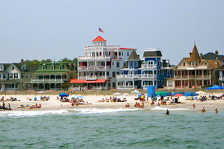
Cape May is a city at the southern tip of Cape May Peninsula in Cape May County, New Jersey, where the Delaware Bay meets the Atlantic Ocean. One of the country's oldest vacation resort destinations, it is part of the Ocean City Metropolitan Statistical Area. As of the 2010 United States Census, the city had a year-round population of 3,607, reflecting a decline of 427 (-10.6%) from the 4,034 counted in the 2000 Census, which had in turn declined by 634 (-13.6%) from the 4,668 counted in the 1990 Census. In the summer, Cape May's population is expanded by as many as 40,000 to 50,000 visitors. The entire city of Cape May is designated the Cape May Historic District, a National Historic Landmark due to its concentration of Victorian buildings.

Lower Township is a township in Cape May County, New Jersey, United States. It is part of the Ocean City Metropolitan Statistical Area. As of the 2010 United States Census, the township's population was 22,866, reflecting a decrease of 79 (-0.3%) from the 22,945 counted in the 2000 Census, which had in turn increased by 2,125 (+10.2%) from the 20,820 counted in the 1990 Census.

Ocean City is a city in Cape May County, New Jersey, United States. As of the 2010 United States Census, the city's population was 11,701, reflecting a decline of 3,677 (-23.9%) from the 15,378 counted in the 2000 Census, which had in turn declined by 134 (-0.9%) from the 15,512 counted in the 1990 Census. In summer months, with an influx of tourists and second homeowners, there are estimated to be 115,000 to 130,000 within the city's borders.
West Cape May is a Walsh Act borough in Cape May County, New Jersey, United States. It is part of the Ocean City Metropolitan Statistical Area. As of the 2010 United States Census, the borough's population was 1,024, reflecting a decline of 71 (-6.5%) from the 1,095 counted in the 2000 Census, which had in turn increased by 69 (+6.7%) from the 1,026 counted in the 1990 Census.

Wildwood is a city in Cape May County, New Jersey, United States. It is part of the Ocean City Metropolitan Statistical Area and is a popular summer resort destination along the Jersey Shore. As of the 2010 United States Census, the city's year-round population was 5,325, reflecting a decline of 111 (-2.0%) from the 5,436 counted in the 2000 Census, which had in turn increased by 952 (+21.2%) from the 4,484 counted in the 1990 Census. With visitors, the population can swell to 250,000 during the summer months. Wildwood was the first city in New Jersey to have a female mayor, Doris W. Bradway, who was ousted in a 1938 recall election.

Route 162 is an unsigned 0.70-mile (1.13 km) long state highway in Lower Township, New Jersey, United States. The highway's designation consists entirely of a bridge on Seashore Road, which is known as Relocated Seashore Road. The southern terminus of the highway is an intersection with County Routes 641 and 626 in Lower Township. After crossing the Cape May Canal, Route 162 terminates at an intersection with County Routes 603 and 626 in Lower Township. Route 162 and County Route 626 date back to the 1850s, when local businessmen and county financial Richard Holmes put together the Cape May Turnpike. The turnpike was chartered in 1854, but construction did not begin until 1857, with completion in April of the next year. The turnpike however, caused a lot of controversy, and struggled to live. For many years, railroads were proposed, becoming possible competition for Holmes, who did not appreciate the idea. The railroad was constructed in 1863, just nine years after the charter of the turnpike syndicate.

Friends General Conference (FGC) is a North American Quaker association of 15 Quaker yearly and 12 monthly meetings in the United States and Canada that choose to be members. FGC was founded in 1900.

The Jersey Shore is the coastal region of the U.S. state of New Jersey. Geographically, the term encompasses about 141 miles (227 km) of oceanfront bordering the Atlantic Ocean, from Perth Amboy in the north to Cape May Point in the south. The region includes Middlesex, Monmouth, Ocean, Atlantic, and Cape May counties. Many New Jersey residents refer to it simply as "The Shore", as in to go or have done something "down the shore". While there is no defined border between North Jersey and South Jersey, the Raritan River, Manasquan River, or I-195 are often mentioned as the border, and as such, most of the shore region is located in South Jersey.

Cape May is a peninsula and island ; the southern tip of the island is the southernmost point of the U.S. state of New Jersey. The peninsula resides in Cape May County and runs southwards from the New Jersey mainland, separating Delaware Bay from the Atlantic Ocean. The cape is named for Cornelius Jacobsen Mey, a Dutch explorer who was working for the Dutch East India Company.

Delaware Bay is the estuary outlet of the Delaware River on the Northeast seaboard of the United States. Approximately 782 square miles (2,030 km2) in area, the bay's fresh water mixes for many miles with the salt water of the Atlantic Ocean.

South Jersey comprises the southern portions of the U.S. state of New Jersey between the lower Delaware River and the Atlantic Ocean. The designation of southern New Jersey with a distinct toponym is a colloquial one rather than an administrative one, reflecting not only geographical but also perceived cultural differences from the northern part of the state, with no official definition. Though definitions of South Jersey may vary, most of South Jersey is generally considered to be part of the Philadelphia Metropolitan Area.
Sunset Beach may refer to:
A bird observatory is a centre for the study of bird migration and bird populations. They are usually focused on local birds, but may also include interest in far-flung areas. Most bird observatories are small operations with a limited staff, many volunteers and a not-for-profit educational status. Many bird observatories conduct bird ringing or bird banding.
The New Jersey Coastal Heritage Trail Route extends along eastern and southern coast of New Jersey for nearly 300 miles. It travels along the Raritan Bay from Perth Amboy to Sandy Hook, along Jersey Shore at the Atlantic Ocean to Cape May, and along the Delaware Bay to the Delaware Memorial Bridge. The trail encompasses a variety of New Jersey state parks along with facilities under the jurisdiction of the National Park Service.
A headland is a coastal landform, a point of land usually high and often with a sheer drop, that extends into a body of water. It is a type of promontory. A headland of considerable size often is called a cape. Headlands are characterised by high, breaking waves, rocky shores, intense erosion, and steep sea cliffs.

