Carter County | |
---|---|
Coordinates: 36°18′N82°07′W / 36.3°N 82.12°W | |
Country | United States |
State | Tennessee |
Founded | 1796 |
Named for | Landon Carter [1] |
Seat | Elizabethton |
Largest city | Elizabethton |
Area | |
• Total | 348 sq mi (900 km2) |
• Land | 341 sq mi (880 km2) |
• Water | 6.4 sq mi (17 km2) 1.8% |
Population (2020) | |
• Total | 56,356 |
• Density | 168/sq mi (65/km2) |
Time zone | UTC−5 (Eastern) |
• Summer (DST) | UTC−4 (EDT) |
Congressional district | 1st |
Website | www |
Carter County is a county located in the U.S. state of Tennessee. As of the 2020 census, the population was 56,356. [2] Its county seat is Elizabethton. [3] The county is named in honor of Landon Carter (1760-1800), an early settler active in the "Lost State of Franklin" 1784-1788 secession from the State of North Carolina. Carter County is part of the Johnson City, TN Metropolitan Statistical Area, which is a component of the Johnson City– Kingsport – Bristol, TN-VA Combined Statistical Area, located in northeastern Tennessee.
The area was originally claimed by Britain as part of the Clarendon settlements of the Province of Carolina, although actually populated at the time by the Cherokee.
The area was part of (though seldom actually administered by) the following jurisdictions in its early history:
The county is named for General Landon Carter, [4] the son of John Carter of Virginia, who was "chairman of the court" of the first majority-rule system of American democracy, known as the Watauga Association of 1772. The association was the first permanent settlement established outside the original thirteen American colonies and included the area that is today's Carter County. In 1775, the Association was absorbed into North Carolina by petition, becoming known thereafter as the Washington District.
J. G. M. Ramsey records within his 1853 Annals of Tennessee that the State of Franklin established Wayne County from sections of both Washington County and a part of Wilkes County "lying west of the extreme heights of the Apalachian or Alleghany Mountains, into a separate and distinct county by the name of Wayne... This new county covered the same territory now embraced in the limits of Carter and Johnson counties." [5]
The county seat, Elizabethton, is named for Carter's wife, Elizabeth MacLin Carter. [6]
Like most East Tennessee counties, Carter Countians opposed secession on the eve of the Civil War. In Tennessee's Ordinance of Secession referendum on June 8, 1861, Carter Countians rejected secession by a vote of 1,343 to 86. [7] A railroad bridge at Carter's Depot (modern Watauga) was among those targeted by the East Tennessee bridge-burning conspiracy in November 1861. [8]
Carter County was served by the narrow gauge East Tennessee and Western North Carolina Railroad (The ET&WNC, nicknamed "Tweetsie") until the line ceased operations in 1950.
According to the U.S. Census Bureau, the county has a total area of 348 square miles (900 km2), of which 341 square miles (880 km2) is land and 6.4 square miles (17 km2) (1.8%) is water. [9]
Carter County is situated entirely within the Blue Ridge Mountains, specifically the Unaka Range and the Iron Mountains. [10] Roan Mountain, which at 6,285 feet (1,916 m) is the highest point in Tennessee outside the Great Smoky Mountains, straddles the county's eastern border with North Carolina. The county's boundary with Sullivan County is defined as the ridgeline of Holston Mountain.
Carter County is served by the Carter County Sheriff's Office, located in Elizabethton. During the Local General Election on August 4, 2022, Mike Fraley overcame the Independent candidate to become Sheriff of Carter County. Sheriff Fraley took over Official Duties as Sheriff on September 1. [12] Sheriff Fraley's term will run September 1, 2022, to August 31, 2026. Its duties include patrol of the county and all jail and prisoner matters. [13]
The Elizabethton Police Department services the City of Elizabethton inside Carter County. As of 2018, the Chief of Police is Jason Shaw. [14]
Climate data for Carter County, Tennessee (Bristol-Johnson City) | |||||||||||||
---|---|---|---|---|---|---|---|---|---|---|---|---|---|
Month | Jan | Feb | Mar | Apr | May | Jun | Jul | Aug | Sep | Oct | Nov | Dec | Year |
Mean daily maximum °F (°C) | 43.7 (6.5) | 48.0 (8.9) | 58.9 (14.9) | 67.4 (19.7) | 75.2 (24.0) | 82.2 (27.9) | 84.6 (29.2) | 84.1 (28.9) | 79.1 (26.2) | 69.1 (20.6) | 58.2 (14.6) | 48.1 (8.9) | 66.6 (19.2) |
Daily mean °F (°C) | 34.0 (1.1) | 37.4 (3.0) | 47.2 (8.4) | 55.2 (12.9) | 63.4 (17.4) | 71.1 (21.7) | 74.4 (23.6) | 73.6 (23.1) | 67.9 (19.9) | 56.7 (13.7) | 47.0 (8.3) | 38.2 (3.4) | 55.5 (13.1) |
Mean daily minimum °F (°C) | 24.3 (−4.3) | 26.8 (−2.9) | 35.4 (1.9) | 43.0 (6.1) | 51.6 (10.9) | 59.9 (15.5) | 64.1 (17.8) | 63.1 (17.3) | 56.6 (13.7) | 44.2 (6.8) | 35.9 (2.2) | 28.2 (−2.1) | 44.4 (6.9) |
Average rainfall inches (mm) | 3.2 (81) | 3.4 (86) | 3.7 (94) | 3.3 (84) | 3.8 (97) | 3.5 (89) | 4.3 (110) | 3.2 (81) | 3.3 (84) | 2.6 (66) | 2.9 (74) | 3.4 (86) | 40.7 (1,030) |
Average snowfall inches (cm) | 5.2 (13) | 4.2 (11) | 2.3 (5.8) | 0.4 (1.0) | 0.0 (0.0) | 0.0 (0.0) | 0.0 (0.0) | 0.0 (0.0) | 0.0 (0.0) | 0.0 (0.0) | 0.9 (2.3) | 2.6 (6.6) | 15.6 (40) |
Average relative humidity (%) | 59.0 | 71.5 | 69.0 | 67.0 | 69.5 | 73.0 | 75.0 | 76.5 | 76.5 | 74.0 | 68.5 | 69.5 | 74.0 |
Source: Climate-zone.com [15] |
Census | Pop. | Note | %± |
---|---|---|---|
1800 | 4,813 | — | |
1810 | 4,190 | −12.9% | |
1820 | 4,835 | 15.4% | |
1830 | 6,414 | 32.7% | |
1840 | 5,372 | −16.2% | |
1850 | 6,296 | 17.2% | |
1860 | 7,124 | 13.2% | |
1870 | 7,909 | 11.0% | |
1880 | 10,019 | 26.7% | |
1890 | 13,389 | 33.6% | |
1900 | 16,688 | 24.6% | |
1910 | 19,838 | 18.9% | |
1920 | 21,488 | 8.3% | |
1930 | 29,223 | 36.0% | |
1940 | 35,127 | 20.2% | |
1950 | 42,432 | 20.8% | |
1960 | 41,578 | −2.0% | |
1970 | 42,575 | 2.4% | |
1980 | 50,205 | 17.9% | |
1990 | 51,505 | 2.6% | |
2000 | 56,742 | 10.2% | |
2010 | 57,424 | 1.2% | |
2020 | 56,356 | −1.9% | |
2022 (est.) | 56,410 | 0.1% | |
U.S. Decennial Census [16] 1790-1960 [17] 1900-1990 [18] 1990-2000 [19] 2010-2014 [20] |
Race | Number | Percentage |
---|---|---|
White (non-Hispanic) | 51,790 | 91.9% |
Black or African American (non-Hispanic) | 702 | 1.25% |
Native American | 153 | 0.27% |
Asian | 231 | 0.41% |
Pacific Islander | 7 | 0.01% |
Other/Mixed | 2,292 | 4.07% |
Hispanic or Latino | 1,181 | 2.1% |
As of the 2020 United States census, there were 56,356 people, 23,784 households, and 15,256 families residing in the county.
As of the census [23] of 2000, there were 56,742 people, 23,486 households, and 16,346 families residing in the county. [24] The population density was 166 people per square mile (64 people/km2). There were 25,920 housing units at an average density of 76 units per square mile (29/km2). The racial makeup of the county was 97.49% White, 1.00% Black or African American, 0.20% Native American, 0.26% Asian, 0.01% Pacific Islander, 0.27% from other races, and 0.78% from two or more races. 0.89% of the population were Hispanic or Latino of any race.
There were 23,486 households, out of which 28.50% had children under the age of 18 living with them, 54.90% were married couples living together, 11.00% had a female householder with no husband present, and 30.40% were non-families. 26.50% of all households were made up of individuals, and 11.00% had someone living alone who was 65 years of age or older. The average household size was 2.35 and the average family size was 2.83.
In the county, the population was spread out, with 21.40% under the age of 18, 9.20% from 18 to 24, 29.00% from 25 to 44, 25.40% from 45 to 64, and 15.00% who were 65 years of age or older. The median age was 38 years. For every 100 females, there were 94.50 males. For every 100 females age 18 and over, there were 91.60 males.
The median income for a household in the county was $27,371, and the median income for a family was $33,825. Males had a median income of $26,394 versus $19,687 for females. The per capita income for the county was $14,678. About 12.80% of families and 16.90% of the population were below the poverty line, including 23.00% of those under age 18 and 16.00% of those age 65 or over.
Carter County is a Republican stronghold, and, like most of East Tennessee, has voted consistently Republican since the Civil War. Carter County is even more heavily Republican than many other counties in East Tennessee and has not been won by a Democratic presidential candidate since before the Civil War. Since then, only one Democrat, southerner Jimmy Carter in 1976 (who also won several traditionally Republican counties in East Tennessee), has received over 40% of the popular vote.
Most recent Carter County Mayor Rusty Barnett died on September 21, 2020. [25]
Year | Republican | Democratic | Third party | |||
---|---|---|---|---|---|---|
No. | % | No. | % | No. | % | |
2020 | 19,584 | 79.96% | 4,529 | 18.49% | 379 | 1.55% |
2016 | 16,898 | 80.15% | 3,453 | 16.38% | 733 | 3.48% |
2012 | 15,503 | 75.20% | 4,789 | 23.23% | 325 | 1.58% |
2008 | 15,852 | 72.82% | 5,587 | 25.66% | 330 | 1.52% |
2004 | 15,768 | 70.67% | 6,395 | 28.66% | 150 | 0.67% |
2000 | 12,111 | 63.40% | 6,724 | 35.20% | 267 | 1.40% |
1996 | 10,540 | 57.65% | 6,218 | 34.01% | 1,524 | 8.34% |
1992 | 10,712 | 55.82% | 6,502 | 33.88% | 1,976 | 10.30% |
1988 | 12,036 | 71.74% | 4,634 | 27.62% | 108 | 0.64% |
1984 | 13,153 | 73.35% | 4,642 | 25.89% | 138 | 0.77% |
1980 | 11,648 | 64.44% | 6,006 | 33.22% | 423 | 2.34% |
1976 | 8,934 | 54.11% | 7,443 | 45.08% | 133 | 0.81% |
1972 | 11,102 | 82.15% | 2,191 | 16.21% | 221 | 1.64% |
1968 | 9,467 | 64.68% | 2,160 | 14.76% | 3,009 | 20.56% |
1964 | 8,472 | 61.40% | 5,326 | 38.60% | 0 | 0.00% |
1960 | 12,214 | 77.31% | 3,412 | 21.60% | 172 | 1.09% |
1956 | 11,218 | 78.80% | 2,933 | 20.60% | 85 | 0.60% |
1952 | 9,019 | 76.15% | 2,707 | 22.86% | 118 | 1.00% |
1948 | 4,943 | 70.94% | 1,809 | 25.96% | 216 | 3.10% |
1944 | 4,873 | 74.33% | 1,662 | 25.35% | 21 | 0.32% |
1940 | 4,238 | 65.40% | 2,171 | 33.50% | 71 | 1.10% |
1936 | 4,858 | 72.27% | 1,837 | 27.33% | 27 | 0.40% |
1932 | 5,055 | 76.26% | 1,574 | 23.74% | 0 | 0.00% |
1928 | 4,934 | 90.40% | 512 | 9.38% | 12 | 0.22% |
1924 | 3,657 | 86.33% | 551 | 13.01% | 28 | 0.66% |
1920 | 6,059 | 89.99% | 674 | 10.01% | 0 | 0.00% |
1916 | 2,961 | 85.60% | 498 | 14.40% | 0 | 0.00% |
1912 | 1,243 | 34.08% | 478 | 13.11% | 1,926 | 52.81% |
Washington County is a county located in the U.S. state of Tennessee. As of the 2020 census, the population was 133,001. Its county seat is Jonesborough. The county's largest city and a regional educational, medical and commercial center is Johnson City. Washington County is Tennessee's oldest county, having been established in 1777 when the state was still part of North Carolina. Washington County is part of the Johnson City, TN Metropolitan Statistical Area, which is a component of the Johnson City–Kingsport–Bristol, TN-VA Combined Statistical Area, commonly known as the "Tri-Cities" region.
Monroe County is a county located on the eastern border of the U.S. state of Tennessee. As of the 2020 census, the population was 46,250. Its county seat is Madisonville, and its largest city is Sweetwater.
Johnson County is a county located in the U.S. state of Tennessee. As of the 2020 census, the population was 17,948. Its county seat is Mountain City. It is the state's northeasternmost county, sharing borders with Virginia and North Carolina.
Greene County is a county located on the eastern border of the U.S. state of Tennessee. As of the 2020 census, the population was 70,152. Its county seat is Greeneville. Greene County comprises the Greeneville, TN Micropolitan Statistical Area.
Elizabethton is a city in, and the county seat of Carter County, Tennessee, United States. Elizabethton is the historical site of the first independent American government located west of both the Eastern Continental Divide and the original Thirteen Colonies.
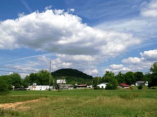
Hunter is a census-designated place (CDP) and unincorporated community located northeast of Elizabethton in Carter County, Tennessee, along Tennessee State Route 91 and the Watauga River. Its population was 1,854 as of the 2010 census. It is part of the Johnson City Metropolitan Statistical Area, which is a component of the Johnson City-Kingsport-Bristol, TN-VA Combined Statistical Area – commonly known as the "Tri-Cities" region. Hunter is a suburb of Elizabethton.
Roan Mountain is a census-designated place (CDP) in Carter County, Tennessee, United States. The population was 1,360 at the 2010 census. It is part of the Johnson City Metropolitan Statistical Area, which is a component of the Johnson City–Kingsport–Bristol, TN-VA Combined Statistical Area – commonly known as the Tri-Cities region.
The Cherokee National Forest is a United States National Forest located in the U.S. states of Tennessee and North Carolina that was created on June 14, 1920. The forest is maintained and managed by the United States Forest Service. It encompasses an estimated area of 655,598 acres (2,653.11 km2).
The Watauga River is a large stream of western North Carolina and East Tennessee. It is 78.5 miles (126.3 km) long with its headwaters in Linville Gap to the South Fork Holston River at Boone Lake.
The Doe River is a tributary of the Watauga River in northeast Tennessee in the United States. The river forms in Carter County near the North Carolina line, just south of Roan Mountain State Park, and flows to Elizabethton.
The Nolichucky River is a 115-mile (185 km) river that flows through western North Carolina and East Tennessee in the southeastern United States. Traversing the Pisgah National Forest and the Cherokee National Forest in the Blue Ridge Mountains, the river's watershed includes some of the highest mountains in the Appalachians, including Mount Mitchell in North Carolina, the highest point in the eastern United States. The river is a tributary of the French Broad River and is impounded by Nolichucky Dam near Greeneville, Tennessee.
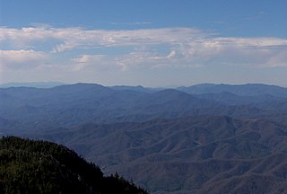
The Unaka Range is a mountain range on the border of Tennessee and North Carolina, in the southeastern United States. It is a subrange of the Appalachian Mountains and is part of the Blue Ridge Mountains physiographic province. The Unakas stretch approximately from the Nolichucky River in the south to the Watauga River in the north.
U.S. Route 19E (US 19E) is a divided highway of US 19 in the U.S. states of North Carolina and Tennessee. The United States Numbered Highway, which is complemented by US 19W to the west, travels 75.9 miles (122.1 km) from US 19 and US 19W at Cane River, North Carolina, north to US 11E, US 19, and US 19W in Bluff City, Tennessee. US 19E connects Asheville, North Carolina, and Bristol, Tennessee, with Burnsville, Spruce Pine, and Elk Park in North Carolina and Roan Mountain and Elizabethton in Tennessee. US 19E also has an unsigned concurrency with State Route 37 (SR 37) for its entire course in Tennessee.
The Sycamore Shoals of the Watauga River, usually shortened to Sycamore Shoals, is a rocky stretch of river rapids along the Watauga River in Elizabethton, Tennessee. Archeological excavations have found Native Americans lived near the shoals since prehistoric times, and Cherokees gathered there. As Europeans began settling the Trans-Appalachian frontier, the shoals proved strategic militarily, as well as shaped the economies of Tennessee and Kentucky. Today, the shoals are protected as a National Historic Landmark and are maintained as part of Sycamore Shoals State Historic Park.
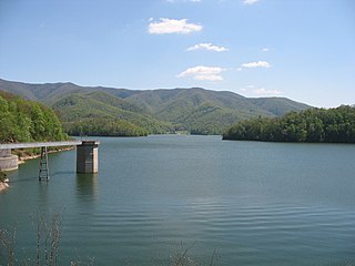
Watauga Lake, located east of Elizabethton, Tennessee, is the local name of the Watauga Reservoir created by the Tennessee Valley Authority (TVA) with the 1948 completion of the TVA Watauga Dam.
Roan Mountain is a 6,285 ft (1,916 m) mountain straddling the North Carolina/Tennessee border in the Unaka Range of the Southern Appalachian Mountains in the Southeastern United States. The range's highpoint, Roan is clad in a dense stand of Southern Appalachian spruce-fir forest, and includes the world's largest natural rhododendron garden, and the longest stretch of grassy bald in the Appalachian range. The Roan Highlands also contain the highest quality remaining stretch of Fraser fir forest throughout the tree's entire range. The Cherokee National Forest and Pisgah National Forest converge atop the mountain, with Roan Mountain State Park located near its northern base. The Appalachian Trail traverses most of the Roan's crest. The Roan High Knob Shelter is the highest back-country shelter on the entire 2,174-mile (3,499 km) trail.
Sycamore Shoals State Historic Area is a state park located in Elizabethton, in the U.S. state of Tennessee. The park consists of 70 acres (28.3 ha) situated along the Sycamore Shoals of the Watauga River, a National Historic Landmark where a series of events critical to the establishment of the states of Tennessee and Kentucky, and the settlement of the Trans-Appalachian frontier in general, took place. Along with the historic shoals, the park includes a visitor center and museum, the reconstructed Fort Watauga, the Carter House and Sabine Hill . For over a thousand years before the arrival of European explorers, Sycamore Shoals and adjacent lands had been inhabited by Native Americans. The first permanent European settlers arrived in 1770, and established the Watauga Association—one of the first written constitutional governments west of the Appalachian Mountains—in 1772. Richard Henderson and Daniel Boone negotiated the Treaty of Sycamore Shoals in 1775, which saw the sale of millions of acres of Cherokee lands in Kentucky and Tennessee and led to the building of the Wilderness Road. During the American Revolution, Sycamore Shoals was both the site of Fort Watauga, where part of a Cherokee invasion was thwarted in 1776, and the mustering ground for the Overmountain Men in 1780.
Hampton is an unincorporated community and Census-designated place in Carter County, Tennessee, United States. Located a few miles southeast of Elizabethton and northwest of Roan Mountain, Hampton is surrounded on all sides by the Unaka Mountains. It is part of the Johnson City Metropolitan Statistical Area, which is a component of the Johnson City–Kingsport–Bristol, TN-VA Combined Statistical Area – commonly known as the "Tri-Cities" region.
State Route 67 is a state-maintained highway in northeastern Tennessee, including a four-lane divided highway segments in both Washington County and Carter County, and part of a significant two-lane segment passing over the Butler Bridge some 80 feet (24 m) above the TVA Watauga Reservoir near Butler in Johnson County, Tennessee.
State Route 91 is a state highway in the northeastern portion of the U.S. state of Tennessee, in the area known as the Tri-Cities region. The route connects Johnson City with Damascus, Virginia via Elizabethton, Hunter, and Mountain City.