Central America Volcanic Arc

Last updated
Map of the Central American volcanic arc, with captions showing the location of several volcanoes - in the Mexico/Guatemala border: Tacana; in Guatemala: Tajumulco, Santa Maria, Chicabal, Toliman, Atitlan, Volcan de Fuego, Volcan de Agua, Pacaya, Chingo; in El Salvador: Apaneca Range, Chinchontepec or San Vicente, Chaparrastique or San Miguel, Chinameca and Conchagua; in Nicaragua: Cosiguina, Telica, Cerro Negro, Momotombo, Apoyeque-Chiltepe, Mombacho and Concepcion; in Costa Rica: Orosi, Rincon de la Vieja, Miravalles, Arenal, Barva, Turrialba and Irazu; in Panama: Baru and La Yeguada. Central America volcanic belt.jpg
Map of the Central American volcanic arc, with captions showing the location of several volcanoes – in the Mexico/Guatemala border: Tacaná; in Guatemala: Tajumulco, Santa Maria, Chicabal, Tolimán, Atitlán, Volcán de Fuego, Volcán de Agua, Pacaya, Chingo; in El Salvador: Apaneca Range, Chinchontepec or San Vicente, Chaparrastique or San Miguel, Chinameca and Conchagua; in Nicaragua: Cosiguina, Telica, Cerro Negro, Momotombo, Apoyeque-Chiltepe, Mombacho and Concepción; in Costa Rica: Orosí, Rincón de la Vieja, Miravalles, Arenal, Barva, Turrialba and Irazú; in Panama: Barú and La Yeguada.

The Central American Volcanic Arc (often abbreviated to CAVA) is a chain of volcanoes which extends parallel to the Pacific coastline of the Central American Isthmus, from Mexico to Panama. This volcanic arc, which has a length of 1,100 kilometers (680 mi) [1] [2] is formed by an active subduction zone, with the Cocos Plate subducting underneath the Caribbean Plate. [3] The region has been volcanically and geologically active for at least the past several million years. Numerous volcanoes are spread throughout various Central American countries; many have been active in the geologic past, some more so than others.

Contents

Tectonic history

The Cocos tectonic plate is along the western edge of Central America. The latter is along the western edge of the Caribbean tectonic plate and can be split into two distinct regimes. [3] These regimes are demarcated roughly by the Costa Rican-Nicaraguan border and can be differentiated by the different tectonic histories of each respective area. The southern portion is part of a magmatic arc, while the northern one is associated with several active margins. [3] Different types of faults also exist within each regime [3] and further serve to differentiate the northern and southern regions' geologic and tectonic histories from one another.

This Caribbean-Cocos tectonic plate interaction can further explain the volcanism and geologic history of the region. While previous literature has shown a wide range of ages for the subduction of the Cocos plate, [4] [5] [6] [7] [8] it is now believed that this subduction began between two million years ago and three million years ago (between 2 Ma and 3 Ma), [9] [10] though the area has been geologically active since at least 12 Ma, as evidenced by plate and plate boundary movements, as well as scarp subduction [9] in the area. A gap in volcanism in Central America between 12 Ma and 5 Ma [9] [10] is understood to have occurred as well.

Furthermore, the subduction of the Cocos tectonic plate itself is not thought to be what caused some of the changes in volcanism associated with the Central American Volcanic Arc; while the subduction of the Cocos Ridge is a continual event that has influenced volcanism in Central America, the subduction of the Coiba Ridge—a microplate in the region-- is thought to be the triggering event [9] that instigated changes in volcanic activity in the geologic past. In short, the interaction of numerous tectonic plates—namely the Cocos, Caribbean, North American, and Coiba [3] [9] [10] plates—over the past several million years has helped facilitate the continual existence of the Central American Volcanic Arc, influencing the tectonic and broad geologic history of the area.

Contemporary regional overview

The Central American Volcanic Arc consists of hundreds of volcanic formations, including stratovolcanoes, composite volcanos, calderas, and lava domes. From a depositional standpoint, ash falls, ash flows, and deposits of tephra are prevalent throughout the region. [1] [11] Carbon and argon isotope dating has been used to date these deposits to the Quaternary, [1] and it is suspected that several of these volcanos have been sporadically active for much of the past 200,000 years. [1]

Some volcanos in the area have even produced large explosive eruptions in the recent past, including the October 25, 1902, eruption of the Santa Maria volcano in Guatemala. [11] This Plinian eruption spewed upwards of twenty cubic kilometers of ash almost thirty kilometers into the sky. [11] Much of this ash was fine-grained, averaging less than 2 millimeters in size. [11]

Similarly, Cerro Negro, a 250-meter-tall volcano in northwest Nicaragua, erupted in 1971, 1992, and 1995. [12] The two latter eruptions, occurring in the 1990’s, had similar magmatic compositions to one another, both broadly basaltic. However, as the water and carbon dioxide contents of each eruption were different—with the earlier eruption having higher levels of carbon dioxide and water vapor, and the later eruption degassing many of its volatiles [12] -- markedly different styles of eruption occurred, with the 1992 eruption of Cerro Negro much more explosive than its 1995 counterpart.

Other volcanos in Central America include the Salvadorian Santa Ana, Izalco, and San Salvador volcanoes, the Nicaraguan Masaya volcano, and the Costa Rican Miravalles, Irazú, and Poás volcanoes. [13] Many remain sporadically active to this day, and likely will continue to be active into the future, as geologic and tectonic processes continue to shape the region.

Notes

  1. 1 2 3 4 Rose, W., Conway, F., Pullinger, C., Deino, A. and McIntosh, W., 1999. An improved age framework for late Quaternary silicic eruptions in northern Central America. Bulletin of Volcanology, 61(1-2), pp.106-120.
  2. Whattam, S. and Stern, R., 2015. Arc magmatic evolution and the construction of continental crust at the Central American Volcanic Arc system. International Geology Review, 58(6), pp.653-686.
  3. 1 2 3 4 5 Álvarez-Gómez, J., Meijer, P., Martínez-Díaz, J. and Capote, R., 2008. Constraints from finite element modeling on the active tectonics of northern Central America and the Middle America Trench. Tectonics, 27(1)
  4. Abratis, M., 1998. Geochemical variations in magmatic rocks from southern Costa Rica as a consequence of Cocos Ridge subduction and uplift of the Cordillera de Talamanca. PhD thesis, Universitat zu Gottingen, p. 134.
  5. deBoer, J.Z., Drummond, M.S., Bordelon, M.J., Defant, M.J., Bellon, H., Maury, R.C., 1995. Cenozoic magmatic phases of the Costa Rican island arc (Cordillera de Talamanca). In: Mann, P. (Ed.), Geologic and Tectonic Development of the Caribbean Plate Boundary in Southern Central America. Spec. Pap.-Geol. Soc. Am. 295, pp. 35– 55.
  6. Grafe, K., 1998. Exhumation and thermal evolution of the Cordillera de Talamanca (Costa Rica): constraints from fission track analysis, 40Ar – 39Ar and 87Rb– 87Sr chronology. PhD thesis, Universitat Tubingen, p. 113.
  7. Collins, L.S., Coates, A.G., Jackson, J.B.C., Obando, J.A., 1995. Timing and rates of emergence of the Limon and Bocas del Toro basins: Caribbean effects of Cocos Ridge subduction? In: Mann, P. (Ed.), Geologic and Tectonic Development of the Caribbean Plate Boundary in Southern Central America. Spec. Pap.-Geol. Soc. Am. 295, pp. 263– 289.
  8. Lonsdale, P., Klitgord, K.D., 1978. Structure and tectonic history of the eastern Panama Basin. Geol. Soc. Amer. Bull. 89, 981–999.
  9. 1 2 3 4 5 MacMillan, I., Gans, P. and Alvarado, G., 2004. Middle Miocene to present plate tectonic history of the southern Central American Volcanic Arc. Tectonophysics, 392(1-4), pp.325-348.
  10. 1 2 3 Morell, K., Kirby, E., Fisher, D. and van Soest, M., 2012. Geomorphic and exhumational response of the Central American Volcanic Arc to Cocos Ridge subduction. Journal of Geophysical Research: Solid Earth, 117(B4)
  11. 1 2 3 4 Williams, S. and Self, S., 1983. The October 1902 plinian eruption of Santa Maria volcano, Guatemala. Journal of Volcanology and Geothermal Research, 16(1-2), pp.33-56.
  12. 1 2 Roggensack, K., Hervig, R., McKnight, S. and Williams, S., 1997. Explosive Basaltic Volcanism from Cerro Negro Volcano: Influence of Volatiles on Eruptive Style. Science, 277(5332), pp.1639-1642.
  13. Melián, G. et al., 2005. Subduction process and diffuse CO2 degassing rates along Central America volcanic arc, Geophysical Research Abstracts, Vol. 7, 09598, 2005

Related Research Articles

<span class="mw-page-title-main">Geography of Panama</span>

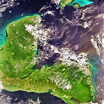
Panama is a country located in Central America, bordering both the Caribbean Sea and the Pacific Ocean, between Colombia and Costa Rica. Panama is located on the narrow and low Isthmus of Panama.

<span class="mw-page-title-main">Ring of Fire</span> Region around the rim of the Pacific Ocean where many volcanic eruptions and earthquakes occur

The Ring of Fire is a tectonic belt of volcanoes and earthquakes.

<span class="mw-page-title-main">Cocos Plate</span> Young oceanic tectonic plate beneath the Pacific Ocean off the west coast of Central America

The Cocos Plate is a young oceanic tectonic plate beneath the Pacific Ocean off the west coast of Central America, named for Cocos Island, which rides upon it. The Cocos Plate was created approximately 23 million years ago when the Farallon Plate broke into two pieces, which also created the Nazca Plate. The Cocos Plate also broke into two pieces, creating the small Rivera Plate. The Cocos Plate is bounded by several different plates. To the northeast it is bounded by the North American Plate and the Caribbean Plate. To the west it is bounded by the Pacific Plate and to the south by the Nazca Plate.

<span class="mw-page-title-main">Pacaya</span> Mountain and national park in Guatemala

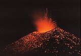
Pacaya is an active complex volcano in Guatemala, which first erupted approximately 23,000 years ago and has erupted at least 23 times since the Spanish conquest of Guatemala. It rises to an elevation of 2,552 metres (8,373 ft). After being dormant for over 70 years, it began erupting vigorously in 1961 and has been erupting frequently since then. Much of its activity is Strombolian, but occasional Plinian eruptions also occur, sometimes showering the area of the nearby Departments with ash.

<span class="mw-page-title-main">Trans-Mexican Volcanic Belt</span> Active volcanic belt that covers central-southern Mexico

The Trans-Mexican Volcanic Belt, also known as the Transvolcanic Belt and locally as the Sierra Nevada, is an active volcanic belt that covers central-southern Mexico. Several of its highest peaks have snow all year long, and during clear weather, they are visible to a large percentage of those who live on the many high plateaus from which these volcanoes rise.

<span class="mw-page-title-main">Sunda Arc</span> Volcanic island arc in Indonesia

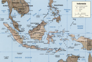
The Sunda Arc is a volcanic arc that produced the volcanoes that form the topographic spine of the islands of Sumatra, Nusa Tenggara, Java, the Sunda Strait, and the Lesser Sunda Islands. The Sunda Arc begins at Sumatra and ends at Flores, and is adjacent to the Banda Arc. The Sunda Arc is formed via the subduction of the Indo-Australian Plate beneath the Sunda and Burma plates at a velocity of 63–70 mm/year.

<span class="mw-page-title-main">Caribbean Plate</span> A mostly oceanic tectonic plate including part of Central America and the Caribbean Sea

The Caribbean Plate is a mostly oceanic tectonic plate underlying Central America and the Caribbean Sea off the northern coast of South America.

<span class="mw-page-title-main">Cerro Azul (Chile volcano)</span> Mountain in Curicó Province, Chile

Cerro Azul, sometimes referred to as Quizapu, is an active stratovolcano in the Maule Region of central Chile, immediately south of Descabezado Grande. Part of the South Volcanic Zone of the Andes, its summit is 3,788 meters (12,428 ft) above sea level, and is capped by a summit crater that is 500 meters (1,600 ft) wide and opens to the north. Beneath the summit, the volcano features numerous scoria cones and flank vents.

<span class="mw-page-title-main">Northern Cordilleran Volcanic Province</span> Geologic province in the Pacific Northwest of North America

The Northern Cordilleran Volcanic Province (NCVP), formerly known as the Stikine Volcanic Belt, is a geologic province defined by the occurrence of Miocene to Holocene volcanoes in the Pacific Northwest of North America. This belt of volcanoes extends roughly north-northwest from northwestern British Columbia and the Alaska Panhandle through Yukon to the Southeast Fairbanks Census Area of far eastern Alaska, in a corridor hundreds of kilometres wide. It is the most recently defined volcanic province in the Western Cordillera. It has formed due to extensional cracking of the North American continent—similar to other on-land extensional volcanic zones, including the Basin and Range Province and the East African Rift. Although taking its name from the Western Cordillera, this term is a geologic grouping rather than a geographic one. The southmost part of the NCVP has more, and larger, volcanoes than does the rest of the NCVP; further north it is less clearly delineated, describing a large arch that sways westward through central Yukon.

<span class="mw-page-title-main">El Valle (volcano)</span>

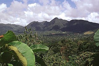
El Valle is a stratovolcano in central Panama and is the easternmost volcano along the Central American Volcanic Arc which has been formed by the subduction of the Nazca Plate below Central America. Some time prior to 200,000 years ago, the volcano underwent a huge eruption event that caused the top of the volcano to collapse into the empty magma chamber below forming a large caldera. Several lava domes have developed inside the caldera since the collapse—forming Cerro Pajita, Cerro Gaital and Cerro Caracoral peaks. Prior to research in the early 1990s, it was thought that no active volcanism existed within Panama. But radioactive dates from El Valle show that the volcano last erupted as recently as 200,000 years ago.

<span class="mw-page-title-main">Volcanism of Canada</span> Volcanic activity in Canada

Volcanic activity is a major part of the geology of Canada and is characterized by many types of volcanic landform, including lava flows, volcanic plateaus, lava domes, cinder cones, stratovolcanoes, shield volcanoes, submarine volcanoes, calderas, diatremes, and maars, along with less common volcanic forms such as tuyas and subglacial mounds.

<span class="mw-page-title-main">Geology of the Pacific Northwest</span> Geology of Oregon and Washington (United States) and British Columbia (Canada)

The geology of the Pacific Northwest includes the composition, structure, physical properties and the processes that shape the Pacific Northwest region of North America. The region is part of the Ring of Fire: the subduction of the Pacific and Farallon Plates under the North American Plate is responsible for many of the area's scenic features as well as some of its hazards, such as volcanoes, earthquakes, and landslides.

<span class="mw-page-title-main">Andean Volcanic Belt</span> Volcanic belt in South America

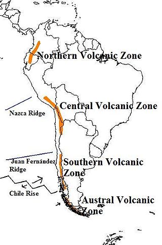
The Andean Volcanic Belt is a major volcanic belt along the Andean cordillera in Argentina, Bolivia, Chile, Colombia, Ecuador, and Peru. It is formed as a result of subduction of the Nazca Plate and Antarctic Plate underneath the South American Plate. The belt is subdivided into four main volcanic zones which are separated by volcanic gaps. The volcanoes of the belt are diverse in terms of activity style, products, and morphology. While some differences can be explained by which volcanic zone a volcano belongs to, there are significant differences within volcanic zones and even between neighboring volcanoes. Despite being a type location for calc-alkalic and subduction volcanism, the Andean Volcanic Belt has a broad range of volcano-tectonic settings, as it has rift systems and extensional zones, transpressional faults, subduction of mid-ocean ridges and seamount chains as well as a large range of crustal thicknesses and magma ascent paths and different amounts of crustal assimilations.

<span class="mw-page-title-main">Izu–Bonin–Mariana Arc</span> Convergent boundary in Micronesia

The Izu–Bonin–Mariana (IBM) arc system is a tectonic plate convergent boundary in Micronesia. The IBM arc system extends over 2800 km south from Tokyo, Japan, to beyond Guam, and includes the Izu Islands, the Bonin Islands, and the Mariana Islands; much more of the IBM arc system is submerged below sealevel. The IBM arc system lies along the eastern margin of the Philippine Sea Plate in the Western Pacific Ocean. It is the site of the deepest gash in Earth's solid surface, the Challenger Deep in the Mariana Trench.

<span class="mw-page-title-main">Panama Plate</span> Small tectonic plate in Central America

The Panama Plate is a small tectonic plate (microplate) that exists between two actively spreading ridges and moves relatively independently of its surrounding plates. The Panama Plate is located between the Cocos Plate and the Nazca Plate to the south and the Caribbean Plate to the north. Most of its borders are convergent boundaries, including a subduction zone to the west. It consists, for the most part, of the countries of Costa Rica and Panama.

Aguas Calientes is a major Miocene caldera in Salta Province, Argentina. It is in the Central Volcanic Zone of the Andes, a zone of volcanism covering southern Peru, Bolivia, northwest Argentina and northern Chile. This zone contains stratovolcanoes and calderas.

Jotabeche is a Miocene-Pliocene caldera in the Atacama Region of Chile. It is part of the volcanic Andes, more specifically of the extreme southern end of the Central Volcanic Zone (CVZ). This sector of the Andean Volcanic Belt contains about 44 volcanic centres and numerous more minor volcanic systems, as well as some caldera and ignimbrite systems. Jotabeche is located in a now inactive segment of the CVZ, the Maricunga Belt.

<span class="mw-page-title-main">La Negra Formation</span> Geologic formation in Chile

La Negra Formation is a geologic formation of Jurassic age, composed chiefly of volcanic and volcaniclastic rocks, located in the Coast Range of northern Chile. The formation originated in marine and continental (terrestrial) conditions, and bears evidence of submarine volcanism as well as large explosive eruptions. The volcanism of La Negra Formation is thought to have lasted for about five million years.

The geology of Nicaragua includes Paleozoic crystalline basement rocks, Mesozoic intrusive igneous rocks and sedimentary rocks spanning the Cretaceous to the Pleistocene. Volcanoes erupted in the Paleogene and within the last 2.5 million years of the Quaternary, due to the subduction of the Cocos Plate, which drives melting and magma creation. Many of these volcanoes are in the Nicaraguan Depression paralleled by the northwest-trending Middle America Trench which marks the Caribbean-Cocos plate boundary. Almost all the rocks in Nicaragua originated as dominantly felsic continental crust, unlike other areas in the region which include stranded sections of mafic oceanic crust. Structural geologists have grouped all the rock units as the Chortis Block.

The geology of Costa Rica is part of the Panama Microplate, which is slowly moving north relative to the stable Caribbean Plate.

References

10°26′31″N84°41′17″W / 10.44194°N 84.68806°W / 10.44194; -84.68806