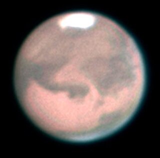
Olympus Mons is a very large shield volcano on the planet Mars. The volcano has a height of nearly 22 km as measured by the Mars Orbiter Laser Altimeter (MOLA). Olympus Mons is about two and a half times Mount Everest's height above sea level. It is the largest volcano, the tallest planetary mountain, and the second tallest mountain currently discovered in the Solar System compared to Rheasilvia on Vesta. It is the youngest of the large volcanoes on Mars, having formed during Mars's Hesperian Period. It had been known to astronomers since the late 19th century as the albedo feature Nix Olympica. Its mountainous nature was suspected well before space probes confirmed its identity as a mountain.
In planetary nomenclature, a fossa is a long, narrow depression (trough) on the surface of an extraterrestrial body, such as a planet or moon. The term, which means "ditch" or "trench" in Latin, is not a geological term as such but a descriptor term used by the United States Geological Survey (USGS) and the International Astronomical Union (IAU) for topographic features whose geology or geomorphology is uncertain due to lack of data or knowledge of the exact processes that formed them. Fossae are believed to be the result of a number of geological processes, such as faulting or subsidence. Many fossae on Mars are probably graben.

Alba Mons is an immense, low-lying volcano located in the northern Tharsis region of the planet Mars. It is the largest volcano on Mars in terms of area, with volcanic flow fields that extend for at least 1,350 km (840 mi) from its summit. Although the volcano has a span comparable to that of the United States, it reaches an elevation of only 6.8 km (22,000 ft) at its highest point. This is about one-third the height of Olympus Mons, the tallest volcano on the planet. The flanks of Alba Mons have very gentle slopes. The average slope along the volcano's northern flank is 0.5°, which is over five times lower than the slopes on the other large Tharsis volcanoes. In broad profile, Alba Mons resembles a vast but barely raised welt on the planet's surface. It is a unique volcanic structure with no counterpart on Earth or elsewhere on Mars.

Amazonis Planitia is one of the smoothest plains on Mars. It is located between the Tharsis and Elysium volcanic provinces, to the west of Olympus Mons, in the Amazonis and Memnonia quadrangles, centered at 24.8°N 196.0°E. The plain's topography exhibits extremely smooth features at several different lengths of scale. A large part of the Medusae Fossae Formation lies in Amazonis Planitia.

The Memnonia quadrangle is one of a series of 30 quadrangle maps of Mars used by the United States Geological Survey (USGS) Astrogeology Research Program. The Memnonia quadrangle is also referred to as MC-16.
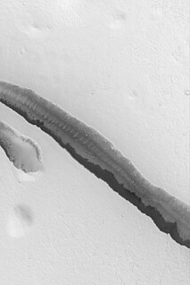
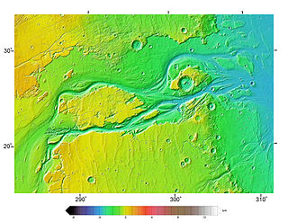
The Cerberus Fossae are a series of semi-parallel fissures on Mars formed by faults which pulled the crust apart in the Cerberus region. They are 1235 km across and centered at 11.28 °N and 166.37 °W.
Their northernmost latitude is 16.16 °N and their southernmost latitude 6.23 °N. Their easternmost and westernmost longitudes are 174.72 °E and 154.43 °E, respectively. They can be seen in the Elysium quadrangle.

Athabasca Valles is a late Amazonian-period outflow channel in the central Elysium Planitia region of Mars, located to the south of the Elysium Rise. It is part of a network of outflow channels in this region that are understood to emanate from large fissures in the Martian surface rather than the chaos terrains that source the circum-Chryse outflow channels. Athabasca Valles in particular emanates from one of the Cerberus Fossae fissures and flows downstream to the southwest, constrained to the south by a wrinkle ridge for over 100 km, before debouching into the Cerberus Palus volcanic plain. Athabasca Valles is widely understood to be the youngest outflow channel on the planet.
Volcanic activity, or volcanism, has played a significant role in the geologic evolution of Mars. Scientists have known since the Mariner 9 mission in 1972 that volcanic features cover large portions of the Martian surface. These features include extensive lava flows, vast lava plains, and the largest known volcanoes in the Solar System. Martian volcanic features range in age from Noachian to late Amazonian, indicating that the planet has been volcanically active throughout its history, and some speculate it probably still is so today. Both Earth and Mars are large, differentiated planets built from similar chondritic materials. Many of the same magmatic processes that occur on Earth also occurred on Mars, and both planets are similar enough compositionally that the same names can be applied to their igneous rocks and minerals.
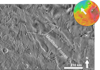
The Medusae Fossae Formation is a large geological unit of probable volcanic origin on the planet Mars. It is named for the Medusa of Greek mythology. "Fossae" is Latin for "trenches". Located roughly at 5°S 213°E, it straddles the highland - lowland boundary near the Tharsis and Elysium volcanic areas. The Medusae Fossae Formation lies partly in five quadrangles: the Amazonis quadrangle, the Tharsis quadrangle, the Memnonia quadrangle, the Elysium quadrangle, and the Aeolis quadrangle.

Tharsis Tholus is an intermediate-sized shield volcano located in the eastern Tharsis region of the planet Mars. The volcano was discovered by the Mariner 9 spacecraft in 1972 and originally given the informal name Volcano 7. In 1973, the International Astronomical Union (IAU) officially designated it Tharsis Tholus. In planetary geology, tholus is the term for a small domical mountain, usually a volcano.

The Elysium quadrangle is one of a series of 30 quadrangle maps of Mars used by the United States Geological Survey (USGS) Astrogeology Research Program. The Elysium quadrangle is also referred to as MC-15.

The Amazonis quadrangle is one of a series of 30 quadrangle maps of Mars used by the United States Geological Survey (USGS) Astrogeology Research Program. The Amazonis quadrangle is also referred to as MC-8.

The Tharsis quadrangle is one of a series of 30 quadrangle maps of Mars used by the United States Geological Survey (USGS) Astrogeology Research Program. The Tharsis quadrangle is also referred to as MC-9 .
The name Tharsis refers to a land mentioned in the Bible. It may be at the location of the old town of Tartessus at the mouth of Guadalquivir.

The Phoenicis Lacus quadrangle is one of a series of 30 quadrangle maps of Mars used by the United States Geological Survey (USGS) Astrogeology Research Program. The Phoenicis Lacus quadrangle is also referred to as MC-17. Parts of Daedalia Planum, Sinai Planum, and Solis Planum are found in this quadrangle. Phoenicis Lacus is named after the phoenix which according to myth burns itself up every 500 years and then is reborn.

Ceraunius Fossae is an area of intensely fractured terrain in the northern Tharsis region of Mars. It lies directly south of the large volcano Alba Mons and consists of ancient highland crust that has been deformed by numerous parallel faults and tension cracks. In places, younger lava flows cover the fractured terrain, dividing it into several large patches or islands. It is found in the Tharsis quadrangle.
Outflow channels are extremely long, wide swathes of scoured ground on Mars, commonly containing the streamlined remnants of pre-existing topography and other linear erosive features indicating sculpting by fluids moving downslope. Channels extend many hundreds of kilometers in length and are typically greater than one kilometer in width; the largest valley is around 3,500 km (2,200 mi) long, greater than 400 km (250 mi) wide and exceeds 2.5 km (1.6 mi) in depth cut into the surrounding plains. These features tend to appear fully sized at fractures in the Martian surface, either from chaos terrains or from canyon systems or other tectonically controlled, deep graben, though there are exceptions. Besides their exceptional size, the channels are also characterized by low sinuosities and high width:depth ratios compared both to other Martian valley features and to terrestrial river channels. Crater counts indicate that most of the channels were cut since the early Hesperian, though the age of the features is variable between different regions of Mars. Some outflow channels in the Amazonis and Elysium Planitiae regions have yielded ages of only tens of million years, extremely young by the standards of Martian topographic features.

Inverted relief, inverted topography, or topographic inversion refers to landscape features that have reversed their elevation relative to other features. It most often occurs when low areas of a landscape become filled with lava or sediment that hardens into material that is more resistant to erosion than the material that surrounds it. Differential erosion then removes the less resistant surrounding material, leaving behind the younger resistant material, which may then appear as a ridge where previously there was a valley. Terms such as "inverted valley" or "inverted channel" are used to describe such features. Inverted relief has been observed on the surfaces of other planets as well as on Earth. For example, well-documented inverted topographies have been discovered on Mars.
HiWish is a program created by NASA so that anyone can suggest a place for the HiRISE camera on the Mars Reconnaissance Orbiter to photograph. It was started in January 2010. In the first few months of the program 3000 people signed up to use HiRISE. The first images were released in April 2010. Over 7000 suggestions were made by the public; suggestions were made for targets in each of the 30 quadrangles of Mars. Selected images released were used for three talks at the 16th Annual International Mars Society Convention. Below are some of the over 4,224 images that have been released from the HiWish program as of March 2016.

Elysium Planitia, located in the Elysium and Aeolis quadrangles, is a broad plain that straddles the equator of Mars, centered at 3.0°N 154.7°E. It lies to the south of the volcanic province of Elysium, the second largest volcanic region on the planet, after Tharsis. Elysium contains the major volcanoes Elysium Mons, Albor Tholus and Hecates Tholus. Another more ancient shield volcano, Apollinaris Mons, is situated just to the south of eastern Elysium Planitia.

Yardangs are common in some regions on Mars, especially in the Medusae Fossae Formation. This formation is found in the Amazonis quadrangle and near the equator. They are formed by the action of wind on sand sized particles; hence they often point in the prevailing direction that the winds were blowing when they were formed. Because they exhibit very few impact craters they are believed to be relatively young. The easily eroded nature of the Medusae Fossae Formation suggests that it is composed of weakly cemented particles, and was most likely formed by the deposition of wind-blown dust or volcanic ash. Yardangs are parts of rock that have been sand blasted into long, skinny ridges by bouncing sand particles blowing in the wind. Layers are seen in parts of the formation. A resistant caprock on the top of yardangs has been observed in Viking, Mars Global Surveyor, and HiRISE photos. Images from spacecraft show that they have different degrees of hardness probably because of significant variations in the physical properties, composition, particle size, and/or cementation.