
Crete is the largest and most populous of the Greek islands, the 88th largest island in the world and the fifth largest island in the Mediterranean Sea, after Sicily, Sardinia, Cyprus, and Corsica. Crete and a number of surrounding islands and islets constitute the region of Crete, one of the 13 top-level administrative units of Greece. The capital and the largest city is Heraklion. As of 2011, the region had a population of 623,065.

Chania is the second largest city of Crete and the capital of the Chania regional unit. It lies along the north coast of the island, about 70 km (43 mi) west of Rethymno and 145 km (90 mi) west of Heraklion.

Heraklion or Heraclion is the largest city and the administrative capital of the island of Crete. It is the fifth largest city in Greece. According to the results of the 2011 census, the population of the city proper was 140,730 inhabitants, the municipality's was 173,993 and it extends over an area of 684.3 km2 (264.2 sq mi).

The Battle of Crete was fought during the Second World War on the Greek island of Crete. It began on the morning of 20 May 1941, when Nazi Germany began an airborne invasion of Crete. Greek and other Allied forces, along with Cretan civilians, defended the island. After one day of fighting, the Germans had suffered heavy casualties and the Allied troops were confident that they would defeat the invasion. The next day, through communication failures, Allied tactical hesitation and German offensive operations, Maleme Airfield in western Crete fell, enabling the Germans to land reinforcements and overwhelm the defensive positions on the north of the island. Allied forces withdrew to the south coast. More than half were evacuated by the British Royal Navy and the remainder surrendered or joined the Cretan resistance. The defence of Crete evolved into a costly naval engagement; by the end of the campaign the Royal Navy's eastern Mediterranean strength had been reduced to only two battleships and three cruisers.
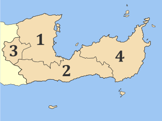
Lasithi is the easternmost regional unit on the island of Crete, to the east of Heraklion. Its capital is Agios Nikolaos, the other major towns being Ierapetra, Sitia and Neapoli. The mountains include the Dikti in the west and the Thrypti in the east. The Sea of Crete lies to the north and the Libyan Sea to the south.

Sitia is a port town and a municipality in Lasithi, Crete, Greece. The town has 9,912 inhabitants (2011) and the municipality has 18,318 (2011). It lies east of Agios Nikolaos and northeast of Ierapetra. Sitia port is on the Sea of Crete, part of the Aegean Sea and is one of the economic centers of the Lasithi region. European route E75, which ends in Vardø, starts in Sitia. Sitia is served by the Sitia Public Airport. Sitia has not experienced the effects of mass tourism even though there is a long beach along the road leading to Vai and several places of historical interest.

Chania is one of the four regional units of Crete; it covers the westernmost quarter of the island. Its capital is the city of Chania. Chania borders only one other regional unit: that of Rethymno to the east. The western part of Crete is bounded to the north by the Cretan Sea, and to the west and south by the Mediterranean Sea. The regional unit also includes the southernmost island of Europe, Gavdos.

The island of Spinalonga is located in the Gulf of Elounda in north-eastern Crete, in Lasithi, next to the town of Plaka. The island is further assigned to the area of Kalydon.
It is near the Spinalonga peninsula – which often causes confusion as the same name is used for both. The official Greek name of the island today is Kalydon.

Legnago is a town and comune in the Province of Verona, Veneto, northern Italy, with population (2012) of 25,439. It is located on the Adige river, about 43 kilometres (27 mi) from Verona. Its fertile land produces crops of rice, other cereals, sugar, and tobacco.
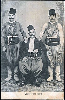
The Cretan Turks, Muslim-Cretans or Cretan Muslims were the Muslim inhabitants of the Greek island of Crete and now their descendants, who settled principally in Turkey, the Dodecanese Islands under Italian administration, Syria, Lebanon, Israel, Libya, and Egypt, as well as in the larger Turkish diaspora.

Cerea is a town and comune in the province of Verona, Veneto, northern Italy.

Souda Bay is a bay and natural harbour near the town of Souda on the northwest coast of the Greek island of Crete. The bay is about 15 km long and only two to four km wide, and a deep natural harbour. It is formed between the Akrotiri peninsula and Cape Drapano, and runs west to east. The bay is overlooked on both sides by hills, with a relatively low and narrow isthmus in the west near Chania.

Bovolone is a town and a comune (municipality) in the Province of Verona in the Italian region Veneto, located about 90 kilometres (56 mi) west of Venice and about 25 kilometres (16 mi) southeast of Verona.
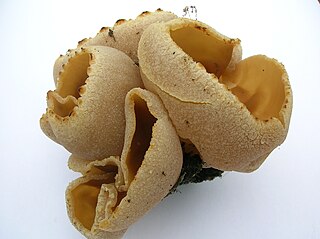
Peziza cerea, commonly known as the Cellar Cup is a species of Ascomycete fungus in the genus Peziza, family Pezizaceae. In common with other Ascomycetes the upper surface of the fungus has a layer of cylindrical spore producing cells called asci, from which the ascospores are forcibly discharged.

The island of Crete was declared an Ottoman province (eyalet) in 1646, after the Ottomans managed to conquer the western part of the island as part of the Cretan War, but the Venetians maintained their hold on the capital Candia until 1669, when Francesco Morosini surrendered the keys of the town. The offshore island fortresses of Souda, Granbousa, and Spinalonga would remain under Venetian rule until in 1715, when they too were captured by the Ottomans.

Rethymno is a city of approximately 40,000 people in Greece, the capital of Rethymno regional unit on the island of Crete, a former Latin Catholic bishopric as Retimo(–Ario) and former Latin titular see.
Associazione Sportiva Dilettantistica Cerea Calcio 1912 or simply Cerea is an Italian association football club based in Cerea, Veneto. Cerea currently plays in Eccellenza Veneto.

Cerea is a railway station in Italy. Located on the Mantua-Monselice railway and Verona-Rovigo railway, it serves the town of Cerea in the province of Verona.
Ceraea or Keraia, also known as Cerea or Kerea (Κερέα), Ceraeae or Keraiai (Κεραῖαι), was town of ancient Crete. It is mentioned by Polybius, and minted coins similar to those of Polyrrhenia in antiquity.
