This article needs additional citations for verification .(March 2007) (Learn how and when to remove this template message) |
| Cerro de la Loma Larga | |
|---|---|
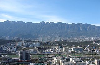
Cerro de la Loma Larga in the foreground | |
| Naming | |
| Translation | Long Hill Mountain(Spanish) |
| Geography | |
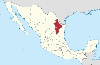
| Location | Nuevo León, Mexico |
| Climbing | |
| Easiest route | Hike |

Cerro de la Loma Larga (literal English: Long Hill Mountain), or Loma Larga (short version), is a lower extension of the Sierra Madre Oriental, particularly of Cerro de las Mitras. located in the Monterrey, Nuevo León metropolitan area.

English is a West Germanic language that was first spoken in early medieval England and eventually became a global lingua franca. It is named after the Angles, one of the Germanic tribes that migrated to the area of Great Britain that later took their name, as England. Both names derive from Anglia, a peninsula in the Baltic Sea. The language is closely related to Frisian and Low Saxon, and its vocabulary has been significantly influenced by other Germanic languages, particularly Norse, and to a greater extent by Latin and French.

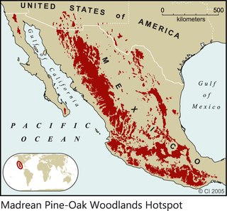
The Sierra Madre Oriental is a mountain range in northeastern Mexico. The Sierra Madre Oriental is part of the American Cordillera, a chain of mountain ranges (cordillera) that consists of an almost continuous sequence of mountain ranges that form the western "backbone" of North America, Central America, South America and Antarctica.

Cerro de las Mitras, named for its distinctive mitre-shaped structures at the very top viewed from the northern side, is a symbol of the landscape of the state of Nuevo León, Mexico. Located in the cities of Monterrey, Santa Catarina and García.
The hill has long been considered the natural division of the now adjacent cities of Monterrey and San Pedro Garza García. The Diana Cazadora statue marking the division of Monterrey and San Pedro Garza García was placed along a busy avenue (Gonzalitos) crossing over the hill. In the early 2000s, the state government completed the Loma Larga Tunnel, which burrows under the mountain to connect Monterrey to San Pedro Garza García.

Monterrey is the capital and largest city of the northeastern state of Nuevo León, Mexico. The city is anchor to the third-largest metropolitan area in Mexico and is the country's ninth-largest city. Monterrey serves as a commercial center of northern Mexico and is the base of many significant international corporations.

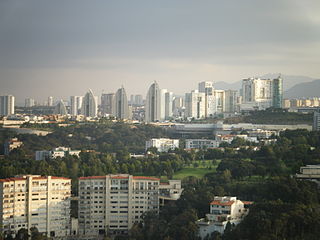
San Pedro Garza García(also known as San Pedro or Garza García) is a city-municipality of the Mexican state of Nuevo León and part of the Monterrey Metropolitan area. It is a contemporary commercial suburb of the larger metropolitan city of Monterrey between Puente de la Unidad and the Alfa Planetarium, including areas surrounding Calzada del Valle/Calzada San Pedro. Cerro de Chipinque and Chipinque Ecological Park are notable aspects of the city. The city hosts the headquarters of corporations such as ALFA, Cemex, Gamesa, Vitro, Pyosa, Softtek The Home Depot México, and Cydsa. With a population of 121,977 (city) and 122,009 (municipality) at the 2005 census, it is the seventh-largest city and eighth-largest municipality in Nuevo León.

Loma Larga Tunnel, or, as it is known by the locals, Túnel de la Loma Larga, is a man-made tunnel constructed in the bowels of the Cerro de la Loma Larga, in the limits of the cities of Monterrey and San Pedro Garza García in Nuevo León, México.
For its length of about 10 kilometres (6.2 mi), it is flanked on its northern side by the Santa Catarina River, and on its southern side, the Sierra Madre Oriental in almost full height.
Nearby geological features make it a relatively unremarkable slope. Residential and commercial development has been built over most of the mountain. The Basílica de Guadalupe is also located on the hill, among other churches.

The Basilica of Guadalupe or Santuario de Nuestra Señora de Guadalupe, has a fifty five gold crowns inside. is a Roman Catholic church located in the metropolitan area of Monterrey, Nuevo León, Mexico. Standing in the neighborhood of Colonia Independencia, just outside the city's downtown area, the temple is one of the larger Church edifices in northern Mexico. It is dedicated to Virgin Mary in her guise as Our Lady of Guadalupe, the Patroness of America, who appeared to St Juan Diego on Tepeyac Hill outside Mexico City in 1531.
Loma Larga is used for some broadcasting. XHRL-FM [1] and XET-AM, [2] among other stations, maintain facilities on the mountain. Other stations use Cerro del Mirador, located to the west.
XHRL-FM is a radio station on 98.1 FM in Monterrey, Nuevo León. The station is owned by NRM Comunicaciones and carries a pop format known as Génesis 98.1.
XET-AM, nicknamed La T Grande, is an AM station on 990 kHz at Monterrey, Nuevo León, Mexico. It is part of Multimedios Radio's Monterrey station cluster.
Some other well-known mountains or elevations of the area are Cerro de la Silla, Cerro de las Mitras, the Sierra Madre Oriental and Cerro de Chipinque with its famous M-shaped figure, the Cerro del Topo Chico, Cerro del Obispado and La Huasteca.

The Cerro de la Silla is a mountain and natural monument located within the metropolitan area of the city of Monterrey, Nuevo León, in northeastern Mexico. Named for its distinctive saddle-shaped profile when viewed from the west, it is a well-known symbol of the city of Monterrey, despite being located in the adjacent municipality of Guadalupe.
Being part of the Sierra Madre Oriental, El Cerro de Chipinque, also known colloquially as "The M" is a figure located on top of the mountain chain, in the state of Nuevo León, México.

Cerro del Topo Chico is a mountain located in the western portion of the city of San Nicolás de los Garza and within the northern limits of the Monterrey metropolitan area.