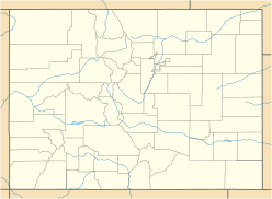
Crested Butte is a prominent mountain summit in the Elk Mountains range of the Rocky Mountains of North America. The 12,168-foot (3,709 m) peak is located in Gunnison National Forest, 2.1 miles (3.4 km) northeast by east of the Town of Crested Butte in Gunnison County, Colorado, United States. Ski lifts and runs of the Crested Butte Mountain Resort occupy the north side of the mountain.

Crater Peak is the highest summit of Grand Mesa in the Rocky Mountains of North America. The prominent 11,333-foot (3,454 m) peak is located on the drainage divide separating Grand Mesa National Forest and Gunnison National Forest, 12.3 miles (19.8 km) north-northwest of the Town of Paonia in Delta County, Colorado, United States.

Tomichi Dome rises north of U.S. Highway 50 west of Hot Springs Creek and south of Wanita Hot Springs Reservoir in the southeast quarter of Gunnison County, Colorado. It is situated within the Gunnison National Forest.

Henry Mountain is a high and prominent mountain summit in the southern Sawatch Range of the Rocky Mountains of North America. The 13,261-foot (4,042 m) thirteener is located in the Fossil Ridge Wilderness of Gunnison National Forest, 7.8 miles (12.5 km) northwest of the Town of Pitkin in Gunnison County, Colorado, United States.

Mount Gunnison is a prominent mountain summit in the West Elk Mountains range of the Rocky Mountains of North America. The 12,725-foot (3,879 m) peak is located in the West Elk Wilderness of Gunnison National Forest, 22.2 miles (35.7 km) west by south of the Town of Crested Butte in Gunnison County, Colorado, United States. The mountain is named in honor of John Williams Gunnison who explored the area.

West Elk Peak, elevation 13,042 ft (3,975 m), is the highest summit in the West Elk Mountains of Gunnison County, Colorado. The mountain is in the West Elk Wilderness, northwest of Gunnison. The terrain consists mostly of volcanic breccia, known in this area as West Elk Breccia, dated at 35 to 30 million years old.

East Beckwith Mountain is a prominent mountain summit in the West Elk Mountains range of the Rocky Mountains of North America. The 12,441-foot (3,792 m) peak is located in the West Elk Wilderness of Gunnison National Forest, 13.4 miles (21.5 km) west by south of the Town of Crested Butte in Gunnison County, Colorado, United States.

Whetstone Mountain, elevation 12,527 ft (3,818 m), is a summit in the Gunnison National Forest of western Colorado. The mountain is located 3 mi (4.8 km) south of Crested Butte in Gunnison County. Whetstone Mountain is one of several prominent laccoliths found in the West Elk Mountains.

Mount Guero is a prominent mountain summit in the West Elk Mountains range of the Rocky Mountains of North America. The 12,058-foot (3,675 m) peak is located in the West Elk Wilderness of Gunnison National Forest, 24.3 miles (39.1 km) west-southwest of the Town of Crested Butte in Gunnison County, Colorado, United States.

Marcellina Mountain is a prominent mountain summit in the West Elk Mountains range of the Rocky Mountains of North America. The 11,353-foot (3,460 m) peak is located in the Raggeds Wilderness of Gunnison National Forest, 15.0 miles (24.1 km) west by north of the Town of Crested Butte in Gunnison County, Colorado, United States.

Blair Mountain is the highest summit of the White River Plateau in the Rocky Mountains of North America. The prominent 11,465-foot (3,495 m) peak is located in White River National Forest, 17.5 miles (28.2 km) north by west of the City of Glenwood Springs in Garfield County, Colorado, United States.

Gothic Mountain is a prominent mountain summit in the West Elk Mountains range of the Rocky Mountains of North America. The 12,631-foot (3,850 m) peak is located in Gunnison National Forest, 1.1 miles (1.8 km) west by south of the ghost town of Gothic in Gunnison County, Colorado, United States. Gothic Mountain takes its name from its pinnacles said to resemble Gothic architecture.

Little Cone is a prominent mountain summit in the San Miguel Mountains range of the Rocky Mountains of North America. The 11,988-foot (3,654 m) peak is located in Uncompahgre National Forest, 15.0 miles (24.1 km) west of the Town of Telluride in San Miguel County, Colorado, United States.

Park Cone, elevation 12,106 ft (3,690 m), is a summit in the Sawatch Range of central Colorado. The mountain is northeast of Gunnison in the Gunnison National Forest.

Green Mountain is a prominent mountain summit in the Kenosha Mountains range of the Rocky Mountains of North America. The 10,427-foot (3,178 m) peak is located in Pike National Forest, 5.2 miles (8.4 km) northwest of the community of Deckers, Colorado, United States, in Jefferson County.

Half Peak is the highest summit of the east central San Juan Mountains in the Rocky Mountains of North America.

Horsefly Peak is the highest summit of the Uncompahgre Plateau in the Rocky Mountains of North America. The 10,353-foot (3,156 m) peak is located 10.0 miles (16.1 km) west by north of the Town of Ridgway in Ouray County, Colorado, United States.

Mount Owen is the highest summit of the Ruby Range of the Rocky Mountains of North America. The 13,070-foot (3,984 m) thirteener is located in Gunnison National Forest at the edge of the Raggeds Wilderness, 8.5 miles (13.6 km) west-northwest of the Town of Crested Butte in Gunnison County, Colorado, United States.

Mount Emmons is a mountain summit in the West Elk Mountains range of the Rocky Mountains in north-central Gunnison County, Colorado, United States.

Italian Mountain is a high mountain summit in the Elk Mountains range of the Rocky Mountains of North America. The 13,385-foot (4,080 m) thirteener is located in Gunnison National Forest, 13.2 miles (21.3 km) east-northeast of the Town of Crested Butte in Gunnison County, Colorado, United States. Italian Mountain was so named because the mountain's tones were said to resemble the colors of the Italian tricolor: green, white, and red.


