Vanuatu, officially the Republic of Vanuatu, is an island country in Melanesia, located in the South Pacific Ocean. The archipelago, which is of volcanic origin, is 1,750 km (1,090 mi) east of northern Australia, 540 km (340 mi) northeast of New Caledonia, east of New Guinea, southeast of Solomon Islands, and west of Fiji.
The history of Vanuatu spans over 3,200 years.

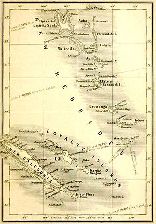
Espiritu Santo is the largest island in the nation of Vanuatu, with an area of 3,955.5 km2 (1,527.2 sq mi) and a population of around 40,000 according to the 2009 census.

Sanma is a province located in the Northern part of the nation of Vanuatu, occupying the nation's largest island, Espiritu Santo, which is located approximately 2,500 km northeast of Sydney, Australia.

Luganville is the second largest city in Vanuatu after the capital Port Vila; it is located on the island of Espiritu Santo and has a population of 18,062 as of the 2020 census. Those on Vanuatu's northern islands who regard Luganville as their big city, particularly indigenous populations, call it Santo; rural residents of Espiritu Santo call it Kanal. Luganville served as a major base of operations for American troops during World War II.
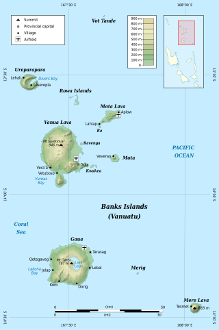
The Banks Islands are a group of islands in northern Vanuatu. Together with the Torres Islands to their northwest, they make up the northernmost province of Torba. The island group lies about 40 km (25 mi) north of Maewo, and includes Gaua and Vanua Lava, two of the 13 largest islands in Vanuatu. In 2009, the islands had a population of 8,533. The island group's combined land area is 780 km2.

Ambae, also known as Aoba, Omba, Oba, or Opa and formerly Lepers’ Island, is an island in the South Pacific island nation of Vanuatu, located near 15°30′S167°30′E, approximately 310 kilometres north-northwest of Vanuatu's capital city, Port Vila. It is also Vanuatu's largest active volcano.

Malo is an island in Vanuatu 3 km (1.9 mi) off the southern coast of Vanuatu's largest island, Espiritu Santo, in Sanma Province. It has a circumference of 55 km (34 mi) and an area of 180 km2 (69 sq mi). It is 17 kilometres or 11 miles long, and 13 kilometres or 8.1 miles across at its widest point. The highest point on the island is Mount Malo.

Santo International Airport is an airport in Luganville on Espiritu Santo in Vanuatu. The airport used to be called Santo-Pekoa International airport until it was renamed in the Vanuatu AIPV amendment released on 16 June 2021. Airports Vanuatu Limited provides aviation services for the airport.

The Coconut War was a brief clash between Papua New Guinean soldiers and rebels in Espiritu Santo shortly before and after the independence of the Republic of Vanuatu was declared on 30 July 1980.

Tropical Cyclone Sose was a moderate storm system that chiefly impacted the island nation of Vanuatu in early April 2001. The developing cyclone was first detected on April 3, while situated well to the northeast of Vanuatu. As atmospheric conditions became more conducive to intensification, the disturbance gradually consolidated as it drifted toward the west-southwest. After receiving the name Sose on April 5, the cyclone was driven southeastward, passing just west of Espiritu Santo and neighboring islands. Although it never made landfall, Sose was particularly expansive, producing a wide area of gale-force winds. The cyclone peaked in strength between April 7 and 8 with maximum 10-minute sustained winds of 110 km/h (68 mph) and 1-minute sustained winds of 130 km/h (81 mph), placing it at Category 2 intensity on the Australian tropical cyclone intensity scale. Ultimately, stronger wind shear and an increasingly hostile upper-air pattern took their toll on the cyclone as it progressed due south; Sose lost tropical characteristics to the northeast of Norfolk Island by April 12. The extratropical remnants of Sose continued into the Tasman Sea.
The Interchange Cable Network is a series of subsea fiber optic cables owned by Vanuatu-based company Interchange Limited. The first cable, ICN1 links Fiji to Vanuatu and has been in service since 15 January 2014.

Tutuba is an island in Vanuatu, located off the coast of Vanuatu's largest island Espiritu Santo in Sanma Province.
Elephant Island is an uninhabited island in Sanma Province of Vanuatu in the Pacific Ocean. Another island off the coast of Antarctica in the outer reaches of the South Shetland Islands, in the Southern Ocean, shares the same name.
Tasmate is the name of several places in Vanuatu.
Dany Island is a tropical island in the Sanma Province of Vanuatu in the Pacific Ocean.The island is privately owned and run as a tourist resort for snorkeling, scuba diving, beach bar and grill, surfing, and deep-sea fishing.
The Espiritu Santo languages are a group of North Vanuatu languages spoken on Espiritu Santo Island in northern Vanuatu. Tryon (2010) considers the Espiritu Santo languages to be a coherent group.
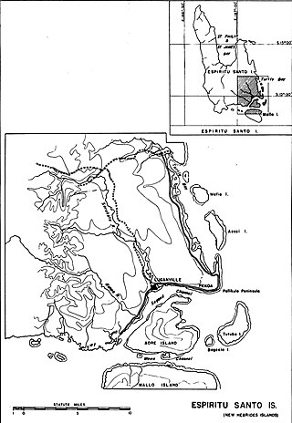
Canal du Segond, also known as Canal Pekoa and in English Segond Channel, literally "Second Channel," separates the island of Aore from the city of Luganville on main island of Espiritu Santo, Vanuatu.

The South Pacific WWII Museum is a military history museum located on the South Pacific island of Espiritu Santo in Vanuatu. The museum is dedicated to preserving and showcasing the history of World War II in the South Pacific region. It serves as an educational and commemorative destination, highlighting the island's role in the Pacific Theatre and rediscovering the lost history of the region.

