Mass Rapid Transit (MRT) terminus | |||||||||||
General information | |||||||||||
Location | 70 Airport Boulevard Singapore 819661 [1] | ||||||||||
Coordinates | 1°21′26.54″N103°59′19.81″E / 1.3573722°N 103.9888361°E | ||||||||||
Operated by | SMRT Trains Ltd (SMRT Corporation) | ||||||||||
Line(s) | |||||||||||
Platforms | 2 (1 island platform) | ||||||||||
Tracks | 2 | ||||||||||
Connections | Changi Airport Bus Terminal, taxi | ||||||||||
Construction | |||||||||||
Structure type | Underground | ||||||||||
Platform levels | 1 | ||||||||||
Parking | Yes (Changi Airport, Jewel Changi Airport) | ||||||||||
Bicycle facilities | Yes (Changi Airport) | ||||||||||
Accessible | Yes | ||||||||||
History | |||||||||||
Opened | 8 February 2002 (as Changi Branch line) | ||||||||||
Opening | 2040Thomson–East Coast line) | (||||||||||
Electrified | Yes | ||||||||||
Passengers | |||||||||||
July 2020 | 4799 per day [2] | ||||||||||
Services | |||||||||||
| |||||||||||
Location | |||||||||||
Changi Airport MRT station is an underground Mass Rapid Transit (MRT) station serving Changi Airport and its supplementary structure Jewel in Changi, Singapore. The station is the terminus of the Changi Airport branch of the East West line (EWL); it is operated by SMRT Trains and is built in an east–west direction. The ends of the station directly connect to Terminals 2 and 3 of Changi Airport.
A rail connection to the airport had been planned since the 1980s but these plans were shelved due to the low viability of such a branch. With increased air traffic to Changi Airport and the proposal of Terminal 3 in 1994, the rail-link plans were revived. The current two-station branch line was finalised in 1996 and construction began in 1998.
The station opened on 8 February 2002, with lower passenger demand than expected but it continues to provide an alternative transport option to the airport. Demand increased when Terminal 3 opened in 2008. On 25 May 2019, it was announced Changi Airport MRT station will be incorporated into the Thomson–East Coast line (TEL) as it extends to the airport's Terminal 5 by 2040. [3] [4]
An MRT branch to Changi Airport was included in early plans of the MRT network in May 1982. [5] The branch was to be built when the rest of the MRT system had been completed. In a 1983 feasibility study, the Mass Rapid Transit Corporation (MRTC) concluded the level of passenger traffic was insufficient to justify such a branch. [6] Plans for the connection were reviewed in 1984 because the MRT system was built below budget. [7] In 1985, a survey on transport patterns to the airport was conducted by an MRTC consultant team to assess the viability of an airport MRT connection. [8] However, the consultants concluded in January 1986 that the connection was unfeasible in the immediate period because travellers preferred to commute to the airport by taxi. [9]
In March 1989, the Member of Parliament for Changi, Teo Chong Tee, called for the airport extension, saying it would serve increased passenger demand to the airport. In response, Communications Minister Yeo Ning Hong said an extension would be considered if there were development plans in the Changi area, otherwise, the low demand might not meet operating costs. [10] In 1991, he stated a connection would only be justified when annual passenger numbers using Changi Airport reached 50 million, and projections said the airport would handle only about 34 million passengers per year at the beginning of the 21st century. The minister also claimed the airport was already well-served by expressways with affordable taxi rates. [11] In 1992, Communications Minister Mah Bow Tan said the government had already reserved land needed for the possible route. [12]
In August 1994, the proposal for a rail link was reconsidered following an increase in airport use that exceeded previous projections (10% compared to 6–7% annually). The Civil Aviation Authority of Singapore (CAAS), which had plans for a new terminal to cater to passenger growth, urged the MRTC to reconsider the proposal for an airport rail link because new roads serving the new terminal might be insufficient. The CAAS also suggested for the new link to be built in tandem with the new terminal. The MRTC opened consultation studies on the airport link, which would branch off from the EWL at Tanah Merah station but there were no plans for intermediate stops. [13] [14]
After another feasibility study by the Land Transport Authority (LTA), Deputy Prime Minister Lee Hsien Loong announced on 15 November 1996 that the 6.4-kilometre (4.0 mi) branch would be built to serve increased demand to the airport. [15] The branch, which was projected to be completed in 2001, would run from Tanah Merah station and have an intermediate stop at Somapah (now Expo) to serve the Changi Business Park and the exhibition centre. [16] [17] There were no plans to extend the branch towards the cargo-and-engineering complexes due to low demand in the area. [18] Teo, who had been advocating for the branch from 1987, was "overjoyed" and considered the announcement an "excellent piece of news". [19]
In October 1998, the contract for the construction of Changi Airport station was awarded to a joint venture between Kumagai-Gumi Co and Sembawang Engineering and Construction for S$ 204.5 million ( US$ 122.2 million). The contract included the construction of the station and associated tunnels, a new baggage tunnel between Terminals 2 and 3, and a new vehicular underpass to serve Terminal 3. [20] This project combined Japanese technology and experience with local knowledge of subcontractor-and-supplier availability. [21] CPG Consultants, which was designing Terminal 3, provided 20 staff to complement the LTA team on the line extension. [22]
A groundbreaking ceremony was held on 29 January 1999. Speaking at the ceremony, Communications Minister Mah Bow Tan highlighted the challenges of constructing the station, which would require close cooperation between parties such as the LTA, CAAS and the contractors. [23] The station site is in a sensitive area and top-down construction works had to be carefully planned to minimise disruption to airport operations. [24] Close monitoring was needed for the construction of the 1 km-long (0.62 mi) tunnel leading to the station, which passes directly beneath the runway and airport terminal. [23]
The carriageways connecting to the arrival and departure halls of Terminals 1 and 2 were diverted temporarily to the west of the station site. [25] The east side of the station was constructed first due to more complex deep excavation works near developments such as Terminal 2. [25] [26] The overrun tunnels beyond the west side of the station would have to pass through an irregular pile layout of the various structures which required extensive foundation reconstruction. The LTA briefly considered mining the tunnels but dismissed the method as the works were in shallow ground. Instead, open-cut excavation within diaphragm walls and ground treatment methods were adopted. [25]
As part of the President's Challenge 2001, a part of a charity walk went through the tunnel between Expo and Changi Airport stations. [27] [28] Changi Airport MRT station opened on 8 February 2002 [29] and the official opening ceremony of the line extension was held on 27 February 2002. [30] Since the station's opening, passenger traffic has been moderate because most bus routes continued to operate and continued to be a popular means of cheap, direct transport for local airport and airline employees, and travellers not living along the East West line. Many air travellers preferred to continue taking taxis or private transport because not all of the trains on MRT services have luggage racks. [31] Taxi drivers said the station put them at a disadvantage, reporting a loss of 20 percent in earnings. By March 2002, about 20,500 commuters were using the station daily. [32] Nevertheless, despite developments build around the branch line to boost further ridership, it was not deemed cost-effective to run through services to the MRT, and hence the branch was instead served by a shuttle service running from Tanah Merah to Changi Airport in 2003. [33] [34]
In July 2016, Transport Minister Khaw Boon Wan announced the possibility of extending the Thomson–East Coast line (TEL) to Changi Airport to provide a more direct connection from the airport to the city. The extension would open at the same time as the future Terminal 5. [35] On 25 May 2019, the LTA announced the line between Tanah Merah and Changi Airport will become part of the TEL when it extends to Changi Airport from Sungei Bedok MRT station via Terminal 5 and will open in 2040. [3] [36] The contract for the construction of twin-bored tunnels from this station to Changi Airport Terminal 5 was awarded to Shanghai Tunnel Engineering Co (Singapore) Pte Ltd for S$321.7 million (US$240.07 million). [37] [38]
Changi Airport station is served by the Changi Airport Branch of the EWL, which connects to the airport from Tanah Merah station as a shuttle service. The official station code is CG2, [43] which changed from EW29 in June 2003. [44] [45] The next station towards Tanah Merah is Expo station. [43] Being part of the EWL, the station is operated by SMRT Trains. [46] In 2040, Changi Airport station will be served by the TEL when the line extends to the airport. [3]
When the station first opened in 2002, it was served by a through service from Boon Lay station. [47] [48] In 22 July 2003, this service reverted to a shuttle service in which trains from Changi Airport station terminated at Tanah Merah station. [33] The day's first train departs Changi Airport station at 5:31 am on weekdays and on Saturdays, at 5:59 am on Sundays. The day's last departs from the airport at 12:06 am. [49] From Tanah Merah station, the day's first train towards Changi Airport station departs at 5:20 am on weekdays and Saturdays, and at 5:47 am on Sundays, and the day's last train towards the airport from Tanah Merah station departs at 11:50 pm. [50] [51] Headways between trains vary from 7 to 13 minutes. [52] [53]
Changi Airport station is 40 metres (130 ft) wide and 200 metres (660 ft) long, and was constructed at a depth of 18.5 metres (61 ft). [21] The station, aligned in an east-west direction, has crossover tracks at its west and overrun tunnels beyond the east side of the station. [54] Architectural firm Skidmore, Owings and Merrill designed the station, [55] and various features have been incorporated into the design to enhance the commuting experience of airport travellers. [30] The station has wide faregates for commuters with luggage. [56] These faregates, which are located on the same level as the station, [57] also allow easier access for wheelchair users into the station. Changi Airport station is one of the first MRT stations to be wheelchair-accessible; it has been retrofitted with lifts and ramps for barrier-free access. [58] A tactile flooring system, consisting of tiles with raised, rounded-or-elongated studs, guides visually impaired commuters through the station. [59]
The station is columnless but supported by platform-edge pillars each spaced 11.4 metres (37 ft) apart and an external diaphragm and lining wall along each length of the station. [60] At the station's two entrances are glass atrium walls that support an illuminated, 150 m (490 ft) bridge that spans the island platform. [55] [56] [61] The glass bridge allows unpaid transfer between the two terminals. [62] At either end of the station is an atrium measuring approximately 60 m (200 ft) long by 36 m (118 ft) high. Australian engineering company Meinhardt Facades provided structural-design engineering of the glazing system and the tensioned-cable structure of the atrium's walls, [63] with engineering input from Ove Arup and Partners. [64]
The atria are designed to allow maximum sunlight into the station and minimal structures are used to maintain the transparency of the atria. [63] The roof is supported only at its northern and southern ends, and a massive beam called the spine runs between the north and south. [62] The spine is supported by a staggered structure made of reinforced concrete at one end and an A-frame column and stability truss at the other end. [63] The facade panels are hung from vertical trusses at the end of each cantilever, and are supported by other cables that runs diagonally and horizontally. [62]
The station design was awarded the 2004 American Architecture Award by Chicago Athenaeum. [65] In 2011, BootsnAll rated the station 10th out of the 15 most-beautiful subway stops in the world. [66]
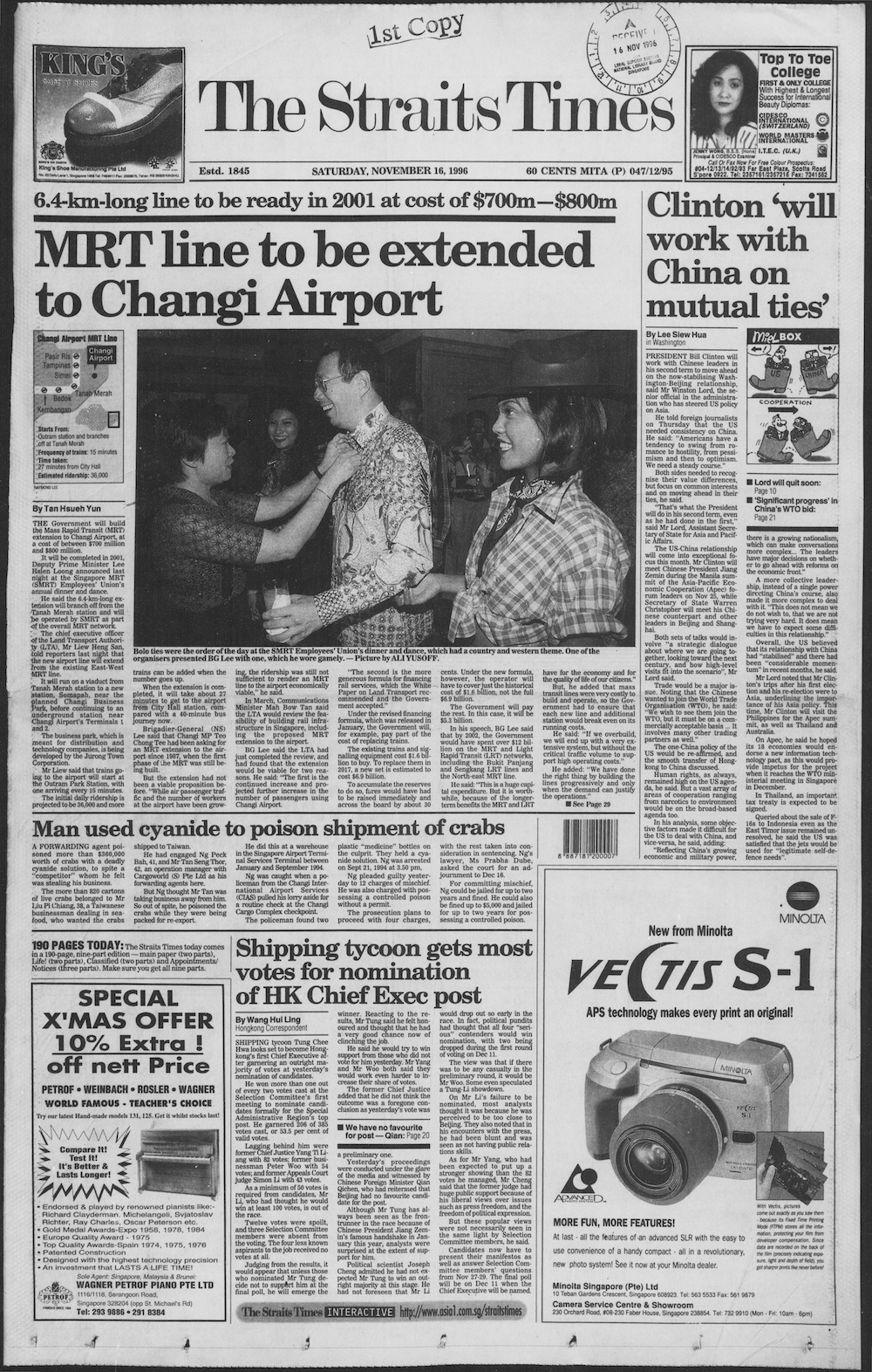
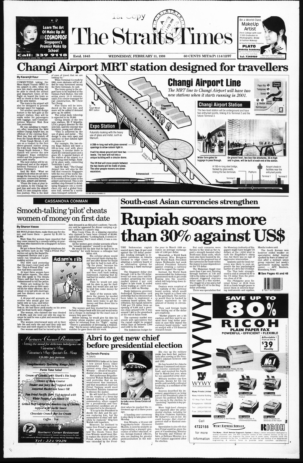
Transportation in Singapore is predominantly land-based, with a comprehensive network of roads making many parts of the city-state, including islands such as Sentosa and Jurong Island, accessible. The road network is complemented by a robust rail system consisting of the Mass Rapid Transit (MRT) and the Light Rail Transit (LRT), which cover the length and width of Singapore and serve a few neighbourhoods respectively. The main island of Singapore is also connected to other islands via ferryboat services. Furthermore, the city-state maintains strong international connections through two bridges linking it to Malaysia – the Causeway and the Second Link – and the Singapore Changi Airport, a major aviation hub in Asia.
The Mass Rapid Transit system, locally known by the initialism MRT, is a rapid transit system in Singapore and the island country's principal mode of railway transportation. The system commenced operations in November 1987 after two decades of planning with an initial 6 km (3.7 mi) stretch consisting of five stations. The network has since grown to span the length and breadth of the country's main island – with the exception of the forested core and the rural northwestern region – in accordance with Singapore's aim of developing a comprehensive rail network as the backbone of the country's public transportation system, averaging a daily ridership of 3.4 million in 2019.
The East–West Line (EWL) is a high-capacity Mass Rapid Transit (MRT) line operated by SMRT in Singapore, running from Pasir Ris station in the east to Tuas Link station in the west, with an additional branch between Changi Airport and Tanah Merah stations. It is the second Mass Rapid Transit line to be built in Singapore. Coloured green on the rail map, the line serves 35 stations, 8 of which are underground. At 57.2 kilometres (35.5 mi), the line is the longest on the MRT network.
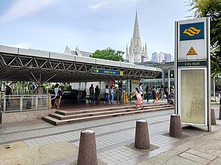
City Hall MRT station is an underground Singapore Mass Rapid Transit (MRT) interchange station on the North–South line (NSL) and East–West line (EWL). Situated in the Downtown Core district, it is underneath Stamford Road near the road junctions with North Bridge Road and St Andrew's Road. The station is near landmarks such as the former City Hall, Raffles City, the Padang, St Andrew's Cathedral and the Cenotaph.
Raffles Place MRT station is an underground Mass Rapid Transit (MRT) interchange station on the North South Line (NSL) and East West Line (EWL) in Singapore. Located in the Downtown Core, the station is underneath Raffles Place south of the Singapore River. The station serves various landmarks including The Fullerton Hotel, Merlion Park and the Asian Civilisations Museum and various commercial buildings such as One Raffles Place and OCBC Centre.
Outram Park MRT station is an underground Mass Rapid Transit (MRT) interchange station in Singapore. The station is on the East–West, North East and Thomson–East Coast lines, and is located near the junction of Outram Road, Eu Tong Sen Street and New Bridge Road on the boundary of Bukit Merah and Outram planning areas. It is the closest MRT station to Singapore General Hospital, the Police Cantonment Complex, Outram Community Hospital and the Health Promotion Board. The station was included in the early plans of the MRT network in 1982; it was constructed as part of the Phase I MRT segment from Novena, and was completed in December 1987.
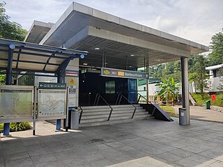
HarbourFront MRT station is an underground Mass Rapid Transit (MRT) interchange station in Singapore. The termini of the North East line (NEL) and Circle line (CCL), the station serves the HarbourFront area and Sentosa. Surrounding retail and commercial developments include VivoCity and HarbourFront Centre, and the station is near HarbourFront Bus Interchange and the Singapore Cruise Centre.
Pasir Ris MRT station is an elevated Mass Rapid Transit (MRT) station on the East West line (EWL) in Pasir Ris, Singapore. Situated along Pasir Ris Central adjacent to Pasir Ris Bus Interchange and the White Sands Shopping Mall, it is the eastern terminus of the EWL and, as of June 2021, the only MRT station within Pasir Ris. The station exterior has the characteristic dome-shaped segmented roof also seen on other elevated EWL stations.
Marina Bay MRT station is an underground Mass Rapid Transit (MRT) interchange station on the North South (NSL), Circle (CCL) and Thomson–East Coast (TEL) lines in Singapore. Located in the Downtown Core district near Marina Bay, the station serves the Marina One Residences, Marina Bay Suites and the Marina Bay Financial Centre.
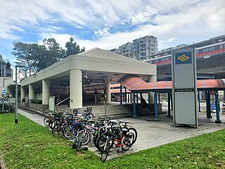
Simei MRT station is an above-ground Mass Rapid Transit (MRT) station on the East–West line in Tampines planning area, Singapore, at the centre of Simei housing estate flanked by Simei Street 1 and Simei Street 3 next to Eastpoint Mall. This station primarily serves Simei, a residential estate part of the larger Tampines New Town.
Expo MRT station is a Mass Rapid Transit (MRT) interchange station on the East West line (EWL) and Downtown line (DTL) in the Tampines planning area, Singapore. The station lies between Changi City Point and the Singapore Expo, located along Changi South Avenue 1 at the junction of Expo Drive.
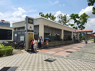
Clementi MRT station is an above-ground Mass Rapid Transit (MRT) station on the East West Line (EWL). Located in Clementi, Singapore, the station is located along Commonwealth Avenue West and serves landmarks such as The Clementi Mall, Clementi Bus Interchange and Clementi Fire Station.
Orchard MRT station is an underground Mass Rapid Transit (MRT) interchange station in Singapore, on the North South (NSL) and Thomson–East Coast (TEL) lines. Situated along Orchard Boulevard and underneath ION Orchard, the station serves various commercial and retail developments of the Orchard Road shopping district, including Liat Towers, Ngee Ann City, Wheelock Place, Wisma Atria and Shaw House, among others.
Tanah Merah MRT station is an elevated Mass Rapid Transit (MRT) station on the East West line (EWL). Located in Bedok, Singapore, the station is along New Upper Changi Road and serves various residential developments, including Casa Merah. It is the terminus of the EWL branch to Changi Airport station.
Toa Payoh MRT station is an underground Mass Rapid Transit (MRT) station on the North South line (NSL) in Toa Payoh, Singapore. Located in the town centre of Toa Payoh, it is integrated with the Toa Payoh Bus Interchange and the HDB Hub, headquarters of the Housing and Development Board. The station is underneath the intersection of three roads: Lorong 1 Toa Payoh, Lorong 2 Toa Payoh and Lorong 6 Toa Payoh.
Bugis MRT station is an underground Mass Rapid Transit (MRT) interchange station on the East–West (EWL) and Downtown (DTL) lines. Situated in Bugis, Singapore, the station is underneath the junction of Rochor Road and Victoria Street. Various developments surrounding the station include Bugis Junction, Raffles Hospital and the National Library. The station is also close to Kampung Glam.
Lavender MRT station is an underground Mass Rapid Transit (MRT) station on the East West line in Kallang, Singapore. Located under Kallang Road, the station is close to the Immigration and Checkpoints Authority (ICA) Building, the former Golden Mile Complex and Jalan Besar Stadium. Planned and built as part of Phase Two of the original MRT network, the contract for the station's construction was awarded in October 1985, and it was opened in November 1989.
The Thomson–East Coast Line (TEL) is a high-capacity Mass Rapid Transit (MRT) line in Singapore. Coloured brown on the rail map, it is fully underground. When fully completed, the sixth line on the country's MRT network will serve 32 stations over 43 kilometres (27 mi) in length, becoming one of the world's longest driverless rapid transit lines. It runs along a combined north–south and east–west corridor, starting in the north at Woodlands town, passing through Upper Thomson and the towns of Ang Mo Kio and Bishan, heading south to the city-centre at Orchard Road and Marina Bay, subsequently heading eastwards along the eastern coast of the country through Kallang, Marine Parade and southern Bedok before ending at Upper East Coast.
Sungei Bedok MRT station is a future underground Mass Rapid Transit interchange and terminal station on the Downtown line and Thomson–East Coast line in Bedok planning area, Singapore. The station is being built east of where Upper East Coast Road becomes Bedok Road, and will serve residents of the Eastwood estate. Nearby facilities include the Bedok Food Centre, Eastwood Centre and the Laguna National Golf & Country Club.
The East Coast Integrated Depot (ECID) is a large integrated bus and train depot located in Changi that will serve three Mass Rapid Transit (MRT) lines in Singapore, the East West Line (EWL), the Downtown Line (DTL) and the Thomson-East Coast Line (TEL). As of 23 January 2024, it is currently under construction, with expected completion in 2025.