Chengannur

Last updated

Chengannur
Municipality
India Kerala location map.svg
Red pog.svg
Chengannur
India location map.svg
Red pog.svg
Chengannur
Coordinates: 9°19′6.54″N76°36′50.46″E / 9.3184833°N 76.6140167°E / 9.3184833; 76.6140167
CountryFlag of India.svg  India
State Kerala
District Alappuzha
Government
  Type Municipality
Area
  Total14.60 km2 (5.64 sq mi)
Elevation
7 m (23 ft)
Population
 (2024)
  Total1,038,386
  Density71,000/km2 (180,000/sq mi)
Time zone UTC+5.30 (IST)
Post code
689121
Area code 0479
Vehicle Code KL-30
Nearest city Kochi (97 km), Thiruvananthapuram (110 km)
Website www.chengannurmunicipality.in
Chengannur Railway Station Chengannur (CNGR).jpg
Chengannur Railway Station

Chengannur (also spelled Chengannoor) is a municipality and Town in Alappuzha district, Kerala, India. It is also the headquarters of the Chengannur Taluk. Chengannur is located in the south-eastern part of the district, in the region known as Odanad, along the banks of Pamba River. [1] Chengannur is 36 kilometres (22 mi) southeast of the district headquarters Alappuzha and 117 kilometres (73 mi) north of the state capital Thiruvananthapuram. Both the NH 183 and Main Central Road (State Highway 1) pass through the town.

Contents

Chengannur is noted for the Chengannur Mahadeva Temple [2] and the Old Syrian Church of the ancient St. Thomas Christians community. It is also a major point for pilgrims to the Sabarimala Temple, and thus has been described as "The Gateway to Sabarimala". [3]

Etymology

The name Chengannur (chem-kunnu-ur/oor) is derived from the words 'chem' (Malayalam) which means red, 'kunnu' (Malayalam) which means hill and 'ur/oor' (Malayalam) meaning land. It means the land of red hills. The red soil of Chengannur was different from the soil of nearby regions of Mavelikara & Kuttanad.

History

Ancient Period

Chengannur was a part of the Ay Kingdom in the ancient period. The Ay Kingdom's territory extended from Pamba River in the north to Nagercoil in the south. Thereafter it came under the sovereignty of the Cheraman Perumals. The earliest epigraphical record to mention Chengannur (Thiruchenkunrur) is the Mampalli copper plate inscription (947 CE) which records a donation from Venad chiefly family to the Chengannur Temple. [4]

Medieval Period

In the medieval age, Chengannur was controlled by the Vanjipuzha chieftains of Mundencavu, of Tulu Brahmin origin. [5] The principality was a feudatory of Odanad. Chengannur came under the Kingdom of Travancore when the area was annexed by Marthanda Varma in 1742. Marthanda Varma transferred the rights over Chengannur from the King of Odanad to the Vanjipuzha family, after the family helped him in his conquests. The economic, social and religious esteem and the political power and sway of Vanjipuzha family over Chengannur continued to be intact throughout even the British period uninterrupted. [4]

In the mid-18th century, there were large-scale migrations from Kollam due to various natural disasters. Black pepper was a major export item of Chengannur. Angadikkal (Angadi means market in Malayalam) was the main market in Chengannur. The current Chengannur market, known as Shastham Puram Chanda, was developed by Velu Thampi Dalawa. During the 19th and 20th centuries, this market played a major role in selling and buying goods produced in the eastern mountains with the towns along the coast.

Early Modern Period

Mahatma Gandhi addressed at the Mills Ground (Mills Maithan is Ksrtc Bus standnow) at Chengannur in 1925 as part of his visit to the Kingdom of Travancore. In 1938 as part of Indian independence movement, large gathering of people from all over Central Travancore were present at the Mills Maithan in Chengannur in response to a notification circulated by the State Congress. There was police lathi charge during the meeting and a person named 'Kutilil George' died and scores of people were injured.

Chengannur Municipality was formed in the year 1980 with Shri. P.K John Plammoottil as its First Municipal Chairman.

Culture

The cultural background of Chengannur originates from the era of Royal rule. Chengannur was a part of Vanjippuzha Principality which was under the rule of Travancore.

Chengannur town is in the banks of holy river Pamba which influenced the culture of this town. There are many "Chundan Vallam" (Snake boats) participating in Aranmula Boat Race hails from Chengannur and nearby areas. Padayani is a traditional temple artform performed as part of the festival in the Vadasserikkavu Devi Temple. Chengannur has produced several great Kathakali artists, the most famous being Chenganoor Raman Pillai. Chengannur was also historically famous for the craftsmen who were brought by rulers of Travancore to build the Sabarimala temple. Idols of the deities of many temples in Kerala were crafted in Chengannur.

Chengannur is a major Shaiva pilgrim destination in India. The Chengannur temple is one of the 108 temples believed to have been created by Parasurama. The Vishnu temples of Chengannur are believed to been established by the Pandavas of the Mahabharatha. These temples are major Vaishnava pilgrim destinations of South India.

The Chengannur Suriyani Church, built by the Vanjipuzha Chiefs, is famous for its unique architecture. The Church is shared by both the Marthoma and Orthodox Christians. There is a 33.5 feet tall cross said to have been carved from a single stone is a minor attraction. The annual custom of Aval Nercha (offering of flattened rice) at this church is another tradition believed to have been initiated by a member nearly 400 years ago. This custom is still practiced by the local Nasrani community and is organised by members of the Mukkath Kudumba Yogam on Maundy Thursday.

Demographics

Historical population
YearPop.±%
193110,738    
194112,543+16.8%
195114,561+16.1%
196122,277+53.0%
197113,316−40.2%
198124,862+86.7%
199125,872+4.1%
200125,397−1.8%
201123,466−7.6%
Source: [6]

As of 2011 Census, Chengannur had a population of 23,466 and a population density of 1,607 inhabitants per square kilometre (4,160/sq mi). Of this, 10,933 are males and 12,533 are females. Chengannur Municipality has an area of 14.6 km2 (5.6 sq mi) with 6,278 families residing in it. The average female sex ratio was 1146 higher than the state average of 1084. 7.2% of the population was under 6 years of age. Chengannur had an average literacy of 97.8% higher than the state average of 94%; male literacy was 98.3% and female literacy was 97.4%. [7]

Religion

Religion in Chengannur (2011) [8]

   Hinduism (61.70%)
   Christianity (37.26%)
   Islam (0.43%)
  None (0.56%)
  Other (0.04%)

According to the 2011 census, Hindus are the majority with 62% of the population adhering to the religion. Christians form a significant minority, constituting 37% of the population. Muslims constitute 0.56% of the population.

Transport

Chengannur is well-connected by road and rail. State Highway 1 (SH1), popularly known as the MC Road, passes through the heart of the town and connects Chengannur to state capital, Thiruvananthapuram and Angamaly in Eranakulam District. The Chengannur - Kottayam stretch of the MC Road is also part of the NH 183 which stretches between Kollam and Theni. Another major road is State Highway 10 which connects Chengannur to Mavelikkara and Kozhencherry. Besides these two roads, there are also many arterial roads running across the length and breadth of the town.

Road

Kerala State Road Transport Corporation has a depot at Chengannur (station code: CGNR); it is among the 29 major depots in the state. The KSRTC depot at Chengannur has an inter-state bus service, which is operated to Kanyakumari. KSRTC runs buses to different cities and towns inside and outside the state. Some of the Major destinations are Thiruvananthapuram, Ernakulam, Thrissur, Kozhikode, Mangalore, Mukambika, Kanyakumari, Coimbatore, Palani, Kannur and Wayanad. The Municipal Private bus stand is located in front of the railway station. Private buses leave this stand heading to various places in the Alappuzha, Kottayam, Pathanamthitta and Kollam districts. In addition to these, private luxury buses are available to Major cities like, Bangalore, Chennai, Coimbatore, Mysore, Salem, Mangalore etc.

Rail

Chengannur Railway Station (station code: CNGR), is an important railway station between Kollam and Kottayam. It is a major railway station in the Thiruvananthapuram railway division of the Southern Railway Zone (India). People from eastern part of the state are using this railway station for travelling to various parts of the country. All the trains traveling through this route stop at Chengannur station. It caters to the needs 3 districts, viz. Alappuzha, Kollam and Pathanamthitta. By rail, Chengannur is well connected to major cities in India like Delhi, Mumbai, Chennai, Kolkata, Bangalore, Hyderabad, Pune, Agra, Ahmedabad, Bikaner, Mangalore, Bhopal, Guwahati, Nagpur, Jammu and other major cities of the country. Recently, the station has been declared as "The Gateway to Sabarimala". The rail line between Chengannur and Thiruvananthapuram has been doubled and electrified. Two new lines are proposed from Chengannur: one to Thiruvananthapuram via Adoor and the other to Sabarimala via Pathanamthitta. Furthermore, an MRTS is proposed to be established between Thiruvananthapuram and Chengannur. There is one more small railway station at Cheriyanadu which is 6 km from the town center.

Climate

Köppen-Geiger climate classification system classifies its climate as tropical monsoon (Am). [9]

Climate data for Chengannur, Kerala
MonthJanFebMarAprMayJunJulAugSepOctNovDecYear
Mean daily maximum °C (°F)31.2
(88.2)
31.7
(89.1)
32.6
(90.7)
32.7
(90.9)
32.1
(89.8)
29.9
(85.8)
29.4
(84.9)
29.4
(84.9)
29.9
(85.8)
30
(86)
30
(86)
30.7
(87.3)
30.8
(87.4)
Daily mean °C (°F)26.8
(80.2)
27.5
(81.5)
28.6
(83.5)
29.1
(84.4)
28.7
(83.7)
26.9
(80.4)
26.5
(79.7)
26.5
(79.7)
26.9
(80.4)
26.9
(80.4)
26.7
(80.1)
26.7
(80.1)
27.3
(81.2)
Mean daily minimum °C (°F)22.5
(72.5)
23.4
(74.1)
24.7
(76.5)
25.5
(77.9)
25.4
(77.7)
24
(75)
23.6
(74.5)
23.7
(74.7)
23.9
(75.0)
23.9
(75.0)
23.5
(74.3)
22.7
(72.9)
23.9
(75.0)
Average precipitation mm (inches)21
(0.8)
34
(1.3)
59
(2.3)
156
(6.1)
308
(12.1)
574
(22.6)
522
(20.6)
358
(14.1)
278
(10.9)
329
(13.0)
211
(8.3)
54
(2.1)
2,904
(114.2)
Source: Climate-Data.org (altitude: 13m) [9]

Politics

Lok Sabha

Chengannur is a part of the Mavelikara constituency which after demarcation extends from Changanassery in Kottayam district to Kottarakkara in Kollam district. Kodikunnil Suresh of the INC has been representing the Mavelikkara constituency since 2009.

State Assembly

Chengannur's assembly constituency (Number 110) is a part of the Mavelikkara (Lok Sabha constituency). The first speaker of the Kerala legislative assembly, Sankaranarayanan Thampi, was an MLA from Chengannur. K. K. Ramachandran Nair was the MLA from 2016 onwards. He died and was replaced in the by-elections conducted on 28 May 2018 by Saji Cherian of Left Democratic Front. [10]

Administration

Chengannur Town officials
Municipal ChairmanSmt. Shoba Varughese
Sub Collector
Deputy Superintendent of Police [11]

The two administrative systems prevailing in the Chengannur are Revenue and local self-government. As per the revenue system, Chengannur is one of the two revenue divisions of Alappuzha district. The Chengannur revenue division comprises Karthikapally, Chengannur and Mavelikkara taluks consisting of a total of 44 villages. Under the local self-government system, Chengannur is divided into 1 statutory town and development blocks consisting of 11 panchayats.

Economy

There are many state Government offices, Banks and educational institutions located in Chengannur. A good number of people work in these institutions. Other major source of income is from the Non Residential Indians, which is a common economical factor in the central Travancore region, and the rest of Kerala as well. Agriculture is also there in the outskirts, but mostly confined to Rubber Plantations. There are no major industries in Chengannur, but a number of small scale industries are present. Major private employers are limited to banks, hospitals and shops.

Chengannur Central Hatchery in chengannur which was started in 1961 was Asia's biggest poultry hatchery under government initiative.

In Sabarimala season, which starts from mid-November to mid-January there is a huge boost in economical activities in this town. Since Chengannur is the nearest Railway station to Sabarimala Temple, [12] most devotees use this railway station to visit the temple. During this season a boost in restaurant, hotel and transportation business is visible.

Notable people


Places of worship

The population of Chengannur mainly practices Hinduism and Christianity. Muslims are also found in the M.C. Road Mulakuzha region of the town. Most of Muslims are living at Kollakadavu and Mannar areas.

The Vanjippuzha Palace had close architectural similarities to that of Thrichittatt Temple Thrichittatt Maha Vishnu Temple1.JPG
The Vanjippuzha Palace had close architectural similarities to that of Thrichittatt Temple

Educational organizations

See also

Related Research Articles

<span class="mw-page-title-main">Alappuzha district</span> District in Kerala, India

Alappuzha district, is one of the 14 districts in the Indian state of Kerala. It was formed as Alleppey district on 17 August 1957, the name of the district being changed to Alappuzha in 1990. Alappuzha is the smallest district of Kerala. Alleppey town, the district headquarters, was renamed Alappuzha in 2012, even though the anglicised name is still commonly used to describe the town as well as the district.

<span class="mw-page-title-main">Kottayam district</span> District in Kerala, India

Kottayam is one of 14 districts in the Indian state of Kerala. Kottayam district comprises six municipal towns: Kottayam, Changanassery, Pala, Erattupetta, Ettumanoor, and Vaikom. It is the only district in Kerala that does not border the Arabian Sea or any other Indian state.

<span class="mw-page-title-main">Pathanamthitta district</span> District in Kerala, India

Pathanamthitta District, is one of the 14 districts in the Indian state of Kerala. The district headquarters is in the town of Pathanamthitta. There are four municipalities in Pathanamthitta: Adoor, Pandalam, Pathanamthitta and Thiruvalla.

<span class="mw-page-title-main">Mavelikkara</span> Town in Kerala, India

Mavelikara is a taluk and municipality in the Onattukara region of Alappuzha district in the Indian state of Kerala. Located in the southern part of the district on the banks of the Achankovil River.

<span class="mw-page-title-main">Kayamkulam</span> Town in Kerala, India

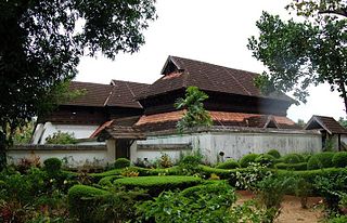
Kayamkulam is a town and municipality in the Onattukara region of Alappuzha district in Kerala. It is the second biggest town in Alappuzha district. It is located on the western coast of India, and was an ancient maritime trading center.Kayamkulam is part of the Karthikappally tehsil. Krishnapuram Palace is located nearby.

<span class="mw-page-title-main">Pamba River</span> River in India

The Pamba River is the longest river in the Indian state of Kerala after Periyar and Bharathappuzha, and the longest river in the erstwhile former princely state of Travancore. Sabarimala Temple dedicated to Lord Ayyappa is located on the banks of the river Pamba.

<span class="mw-page-title-main">Adoor</span> Municipality in Kerala, India

Adoor is a municipality in the Pathanamthitta district of Kerala, India. It is the headquarters of the Adoor Taluk and Adoor Revenue Division. Adoor is located 13.2 km (8.2 mi) southwest of the district headquarters Pathanamthitta and 78.1 km (48.5 mi) north of the state capital Thiruvananthapuram.

<span class="mw-page-title-main">Alappuzha</span> City in Kerala, India

Alappuzha or Alleppey is the administrative headquarters of Alappuzha district in the state of Kerala, India. The Backwaters of Alappuzha are one of the most popular tourist attractions in India which attracts millions of domestic and international tourists.

<span class="mw-page-title-main">Kottarakkara</span> Municipal Town in Kerala, India

Kottarakkara, also transliterated as Kottarakara, is a town and municipality in the Kollam district of the Kerala, India. The town is close to Kollam Port, which has a rich history linked to the early medieval period as well as the reputation as an important commercial, industrial and trading center. Kottarakkara lies 27 kilometres (17 mi) to the east of Kollam city centre.

<span class="mw-page-title-main">Pathanamthitta</span> Town in Kerala, India

Pathanamthitta, is a municipality situated in the Southern Kerala, India, spread over an area of 23.50 km2. It is the administrative capital of Pathanamthitta district. The town has a population of 37,538. The Hindu pilgrim centre Sabarimala is situated in the Pathanamthitta district; as the main transport hub to Sabarimala, the town is known as the 'Pilgrim Capital of Kerala'. Pathanamthitta District, the thirteenth revenue district of the State of Kerala, was formed with effect from 1 November 1982, with headquarters at Pathanamthitta. Forest covers more than half of the total area of the District. Pathanamthitta District ranks the 7th in area in the State. The district has its borders with Allepey, Kottayam, Kollam and Idukki districts of Kerala and Tamil Nadu. Nearest city Is Thiruvalla, located at a distance of 30 km. Thiruvalla railway station Is 30 km via Thiruvalla-Kumbazha highway. Buses ply every 5 Minutes from Thiruvalla To Pathanamthitta & vice versa.

<span class="mw-page-title-main">Elavumthitta</span> Town in Kerala, India

Elavumthitta is a town in Pathanamthitta district of Kerala, India. The majority of its inhabitants are from Hindu and Christian backgrounds. The primary crops are rubber, coconut, black pepper and plantain. The terrain is hilly with plenty of paddy fields in between. It is the commercial centre of Mezhuveli and Chenneerkara panchayaths.

<span class="mw-page-title-main">Nooranad</span> Town in Kerala, India

Nooranad is a developing town in Mavelikkara taluk of Alappuzha district in the Indian state of Kerala. It is located at a distance of 8 Km south-west of Pandalam, in Kayamkulam route. Padanilam is the cultural centre of Nooranad region. The Padanilam Parabrahma Temple, known for the biggest Shivarathri Kettukazhcha in Kerala, is situated in Nooranad. Nooranad is declared by the Government of Kerala as the Nandikesha Paithruka Gramam due to its importance in Kettukala making, which is an icon of Onattukara region of Central Travancore. Nooranad is also known as Pakshi Gramam of kerala.

Valakom is a fastest growing town located on Kerala State highway One, in the Kollam district of Kerala, India, with population 17928. It lies within Kottarakkara municipal town, Ummannoor and edamulackal Panchayat.

<span class="mw-page-title-main">Kottayam railway station</span> Railway station in Kerala, India

Kottayam railway station is located in Kottayam, Kerala state, India. Kottayam railway station is managed by Southern Railway. Kottayam lies on the busy rail route between Thiruvananthapuram and Ernakulam. It is an NSG 3 category station. The station is served by several long-distance trains connecting most major cities in the country on a daily basis like New Delhi, Mumbai, Chennai, Bengaluru, Hyderabad, Coimbatore, Bhopal, Pune and Mangalore. Trains connecting extreme ends of india also passes through the station like Jammu tawi, Dibrugarh etc. It is one of the busiest station in Thiruvananthapuram central - Ernakulam route due to ease in accessibility of Sabarimala temple. Kottayam railway station is the halt station for passengers to Sabarimala temple, Vagamon, Kumarakom, Illickal kallu - high range, St. Alphonsa's tomb, Pala and so on. Station currently has 2 by-passing platforms -, and 3 terminal platforms. All platforms are able to accommodate locomotives with 24 coaches. Station is currently under construction of 1A Platform along with a new entrance. By completing double line from Chingavanam to Ettumanoor, southern railway has achieved its complete stretch of double rail line from Thiruvananthapuram to Mangalore

<span class="mw-page-title-main">Outline of Kerala</span> Overview of and topical guide to Kerala

The following outline is provided as an overview of and topical guide to Kerala:

<span class="mw-page-title-main">Chengannur railway station</span> 3rd main station in alleppy

Chengannur railway station is an 'NSG 3 category' station located at Chengannur in the Indian state of Kerala. It is one of the busiest stations in the Thiruvananthapuram Central–Kollam Junction–Kottayam–Ernakulam route, primarily due to the Sabarimala pilgrims. The station is managed by Southern Railway under the Thiruvananthapuram railway division. Chengannur railway station mainly serves the people of Alappuzha and Pathanamthitta district.

<span class="mw-page-title-main">Tiruvalla railway station</span> Railway station in Kerala

Tiruvalla railway station is a railway station. It is one of the busiest railway station in Thiruvananthapuram Central-Kollam-Kottayam-Ernakulam route, located at Thiruvalla town in Pathanamthitta district, Kerala, India. Tiruvalla is the only railway station in the Pathanamthitta District. The station is under Thiruvananthapuram railway division of Southern Railway. It is an NSG 4 category station and has daily trains to cities like Thiruvananthapuram, Kochi, Kozhikode, Mangalore, Bangalore, Coimbatore, Madurai, Chennai, Hyderabad, Tirupati, Pune, Bhopal, Mumbai and New Delhi.

<span class="mw-page-title-main">Mavelikara railway station</span> Mavelikara railway station

Mavelikara railway station is a railway station (NSG 5 Category) in Alappuzha district, Kerala and falls under the Thiruvananthapuram railway division of the Southern Railway zone, Indian Railways. The station is served by several long-distance trains connecting most major cities in the country like Thiruvananthapuram, Kochi, Kozhikode, Mangalore, Bangalore, Coimbatore, Madurai, Chennai, Hyderabad, Tirupati, Visakhapatnam, Madgaon, Nagpur, Nagercoil, Pune, Bhopal, Ahmedabad, Kolkata, Guwahati, Mumbai and New Delhi.

<span class="mw-page-title-main">Ernakulam–Kottayam–Kayamkulam line</span> Kochi-kottayam-kayamkulam line

The Ernakulam–Kottayam–Kayamkulam line is a railway line which runs through the districts of Ernakulam, Kottayam, Pathanamthitta and Alappuzha in Kerala state of India. This railway line starts as a branch line from Ernakulam Town railway station towards Kottayam and joins with the Ernakulam–Kayamkulam coastal line route via Alappuzha at Kayamkulam Junction. This line comes under the Thiruvananthapuram railway division of Southern Railway Zone of Indian Railways. The line has a total distance of 118 km (73 mi). The Ernakulam Town/Ernakulam Junction - Kottayam section opened in 1956-57 and Kottayam - Kollam section in 1957.

References

  1. "Census of India 2001: Data from the 2001 Census, including cities, villages and towns (Provisional)". Census Commission of India. Archived from the original on 16 June 2004. Retrieved 1 November 2008.
  2. "Chengannur Mahadeva Temple". chengannurtemple.com.
  3. "An online gateway to the Sabarimala". The Hindu. 30 November 2010.
  4. 1 2 3 Cheriyan, Susan (2 February 2009). "Local history of Chengannur: A study of institutions and social relations". Shod Ganga. hdl:10603/22817.
  5. "Easwaran Embran v. Krishnan Embran | Kerala High Court | Judgment | Law | CaseMine". www.casemine.com. Retrieved 17 November 2021.
  6. Office of the Registrar General and Census Commissioner (web), Delimitation Commission of India (web), Rand McNally International Atlas 1994, School of Planning & Architecture (web)
  7. Kerala, Directorate of Census Operations. District Census Handbook, Alappuzha (PDF). Thiruvananthapuram: Directorateof Census Operations,Kerala. p. 182,183. Retrieved 14 July 2020.
  8. https://censusindia.gov.in/nada/index.php/catalog/11379/download/14492/DDW32C-01%20MDDS.XLS [ bare URL ]
  9. 1 2 "Average Temperatures, weather by month, Chengannur weather averages". Climate-Data.org. Retrieved 20 August 2018.
  10. "CPM wins Kerala's Chengannur Assembly seat, bypoll seen as referendum on LDF govt performance". The Times of India. 31 May 2018. Retrieved 6 June 2018.
  11. "sp "Election 2009 - Alappuzha District, Kerala State, India - Observers". Archived from the original on 7 August 2011. Retrieved 22 April 2012."
  12. "How to Reach Sabarimala - Routes To Ayyappan Temple". www.ayyappatemple.in.