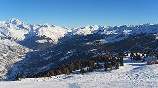
The Alpine region of Switzerland, conventionally referred to as the Swiss Alps, represents a major natural feature of the country and is, along with the Swiss Plateau and the Swiss portion of the Jura Mountains, one of its three main physiographic regions. The Swiss Alps extend over both the Western Alps and the Eastern Alps, encompassing an area sometimes called Central Alps. While the northern ranges from the Bernese Alps to the Appenzell Alps are entirely in Switzerland, the southern ranges from the Mont Blanc massif to the Bernina massif are shared with other countries such as France, Italy, Austria and Liechtenstein.
The Alps form part of a Cenozoic orogenic belt of mountain chains, called the Alpide belt, that stretches through southern Europe and Asia from the Atlantic all the way to the Himalayas. This belt of mountain chains was formed during the Alpine orogeny. A gap in these mountain chains in central Europe separates the Alps from the Carpathians to the east. Orogeny took place continuously and tectonic subsidence has produced the gaps in between.

The Tux Alps or Tux Prealps are a sub-group of the Austrian Central Alps, which in turn form part of the Eastern Alps within Central Europe. They are located entirely within the Austrian federal state of Tyrol. The Tux Alps are one of three mountain ranges that form an Alpine backdrop to the city of Innsbruck. Their highest peak is the Lizumer Reckner, 2,886 m (AA), which rises between the glen of Wattentaler Lizum and the valley of the Navisbach. Their name is derived from the village of Tux which is tucked away in a side valley of the Zillertal.

The Alps cover a large area. This article describes the delimitation of the Alps as a whole and of subdivisions of the range, follows the course of the main chain of the Alps and discusses the lakes and glaciers found in the region.

The Penninic nappes or the Penninicum are one of three nappe stacks and geological zones in which the Alps can be divided. In the western Alps the Penninic nappes are more obviously present than in the eastern Alps, where they crop out as a narrow band. The name Penninic is derived from the Pennine Alps, an area in which rocks from the Penninic nappes are abundant.

The Austroalpine nappes are a geological nappe stack in the European Alps. The Alps contain three such stacks, of which the Austroalpine nappes are structurally on top of the other two. The name Austroalpine means Southern Alpine, because these nappes crop out mainly in the Eastern Alps.

The Hohe Tauern window is a geological structure in the Austrian Central Eastern Alps. It is a window in the Austroalpine nappes where high-grade metamorphic rocks of the underlying Penninic nappes crop out. The structure is caused by a large dome-like antiform in the nappe stacks of the Alps.

The Bündner schist or Bündner slate is a collective name for schistose rocks that form a number of geologic formations in the Penninic nappes of the Alps. Bündner schists were originally marine sediments that underwent metamorphism at large depths.

The Valais Ocean is a subducted oceanic basin which was situated between the continent Europe and the microcontinent Iberia or so called Briançonnais microcontinent. Remnants of the Valais ocean are found in the western Alps and in tectonic windows of the eastern Alps and are mapped as the so-called "north Penninic" nappes.

The Piemont-Liguria basin or the Piemont-Liguria Ocean was a former piece of oceanic crust that is seen as part of the Tethys Ocean. Together with some other oceanic basins that existed between the continents Europe and Africa, the Piemont-Liguria Ocean is called the Western or Alpine Tethys Ocean.

The greywacke zone is a band of Paleozoic metamorphosed sedimentary rocks that forms an east-west band through the Austrian Alps.

The Lepontine dome or Lepontin dome is a region of tectonic uplift in the Swiss part of the Alps. It is located in the Lepontine Alps and Glarus Alps.
The Helvetic nappes are a series of nappes in the Northern part of the Alps and part of the Helvetic zone. They consist of Mesozoic limestones, shales and marls that were originally deposited on the southern continental margin of the European continent. During the Alpine orogeny they were thrusted north over a décollement and at the same time were internally deformed by folding and thrusting.

The Pieniny Klippen Belt is in geology a tectonically and orographically remarkable zone in the Western Carpathians, with a very complex geological structure. It is a narrow and extremely long north banded zone of extreme shortening and sub-vertical strike-slip fault zone, with complex geological history, where only fragments of individual strata and facies are preserved. The Pieniny Klippen Belt is considered one of the main tectonic sutures of the Carpathians and forms the boundary between the Outer and Central Western Carpathians.

An external massif is, in the geology of the Alps, a place where crystalline rocks of the European plate crop out. Such massifs are found north and west of the Penninic zone as tectonic windows in the Helvetic Zone. They differ from the crystalline nappes in that they were originally part of the European plate, while the Penninic nappes were part of the crust below various domains in the Tethys Ocean.

The Engadin window or is a tectonic window that exposes penninic units lying below the austroalpine units in the alpine nappe stack. It has a roughly elliptical shape with the long axis striking northwest-southeast and dimensions of 55 x 17 km.
Cheval noir can refer to:

The geology of Germany is heavily influenced by several phases of orogeny in the Paleozoic and the Cenozoic, by sedimentation in shelf seas and epicontinental seas and on plains in the Permian and Mesozoic as well as by the Quaternary glaciations.
The geology of Austria consists of Precambrian rocks and minerals together with younger marine sedimentary rocks uplifted by the Alpine orogeny.


