
The Xiang River is the chief river of the Lake Dongting drainage system of the middle Yangtze, the largest river in Hunan Province, China. It is the 2nd largest tributary in terms of surface runoff, the 5th largest tributary by drainage area of the Yangtze tributaries. The river flows generally northeast through Guangxi and Hunan two provinces, its tributaries reach into Jiangxi and Guangdong.
A spring creek is a stream that flows from a spring.
Beaver Creek is the name of several places and waterways in North America.

The Trinity River is a 710-mile-long (1,140 km) river in Texas, and is the longest river with a watershed entirely within the U.S. state of Texas. It rises in extreme northern Texas, a few miles south of the Red River. The headwaters are separated by the high bluffs on the southern side of the Red River.
Goose Creek may refer to the following places in the United States:

Barton Creek is a tributary that feeds the Colorado River as it flows through the Texas Hill Country. The creek passes through some of the more scenic areas in Greater Austin, surrounded in many parts by a greenbelt of protected lands that serves as a habitat for many indigenous species of flora and fauna. The creek passes through Barton Creek Greenbelt and is fed by Barton Springs.
Clear Creek may refer to:
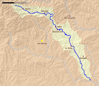
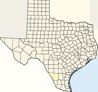
Cibolo Creek is a stream in South Central Texas, United States that runs approximately 96 miles (154 km) from its source at Turkey Knob near Boerne, Texas, to its confluence with the San Antonio River in Karnes County. The creek serves as a tributary of the San Antonio River and forms the easternmost boundary of its watershed.
Chacon Creek is a small stream of water located in Webb County, Texas, USA, which runs through Laredo. The creek is formed 6 miles from Webb and runs southwest for 20 miles until it connects to the Rio Grande. Chacon was dammed in 1951 in east Laredo to form Lake Casa Blanca, a 1,680 acres (6.8 km²) lake. The terrain surrounding the creek is mostly clay. The vegetation surrounding the creek is mostly made up of mesquite, cacti and grasses. Chacon Creek is cross by several highways in Laredo, including United States Route 59, Texas State Highway Loop 20, Texas State Highway Spur 400, Texas State Highway 359 and United States Route 83
San Idelfonso Creek is a small stream of water located in Webb County, Texas which runs through Laredo, Texas. The creek is formed within east Laredo and runs southwest for 8 miles until connecting to the Rio Grande. San Ildefonso Creek was dammed in east Laredo to form San Ildefonso Creek Lake, the second largest Lake in Laredo. The terrain surrounding the creek is mostly clay and sandy loams. The vegetation surrounding the creek is mostly made up of mesquite, cacti, chaparral, hardwoods and grasses. San Idelfonso Creek crosses two major highways in Laredo, Texas among them are: Texas State Highway 359 and United States Route 83
Sombrerillito Creek is a small stream of water located in Webb County, Texas which runs through Laredo, Texas. The creek is formed 13 miles north of Laredo and runs southwest for 16 miles until connecting to the Rio Grande. Sombrerillito Creek was dammed in northwest Laredo to form Sombrerillito Creek Lake, the third largest lake in Laredo. The terrain surrounding the creek is mostly clay and sandy loams. The vegetation surrounding the creek is mostly made up of mesquite, cacti, chaparral, hardwoods and grasses. Sombrerillito Creek crosses one major highway in Laredo, Texas among them are: Farm to Market Road 1472.
Santa Isabel Creek is a small stream of water located in Webb County, Texas which runs through Laredo, Texas. The creek is formed 32 miles from Callaghan, Texas and runs southwest for 33 mi (53 km) until the creek connects to the Rio Grande. The terrain surrounding the creek is mostly clay. The vegetation surrounding the creek is mostly made up of mesquite, cacti, and grasses. Santa Isabel Creek crosses Three major highways in Laredo, Texas among them are: Farm to Market Road 1472, Texas State Highway 255, and United States Route 83.
San Ygnacio Creek is a small stream of water located in Webb County, Texas which runs through Laredo, Texas. The creek is formed 11 miles northwest of Laredo, Texas and runs southwest for 12 mi (19 km) until the creek connects to the Lake Casa Blanca. The terrain surrounding the creek is mostly clay. The vegetation surrounding the creek is mostly made up of mesquite, cacti, and grasses. San Ygnacio Creek does not cross any major highway.

Village Creek State Park is a state park in the Piney Woods of eastern Texas in the Hardin County city of Lumberton. The heavily forested, 1,090 acres (441 ha) park opened in 1994. It is named for Village Creek, a clean, sand-bottomed, free-flowing tributary of the Neches River.

Caney Creek is a river in Texas that begins northwest of Wharton, flows generally southeast, and empties into the Gulf of Mexico near Sargent. The major waterway to the west is the Colorado River while the next major waterway to the east is the San Bernard River.

Buffalo Lake National Wildlife Refuge is a protected area in Randall County in the Texas Panhandle. Its shortgrass prairies spill into marshes, woodlands, riparian habitat, croplands, and water-carved canyon walls that together form 7,664 acres (31.02 km2) of homes for migratory and year-round wildlife. The area forms a habitat for black-tailed prairie dogs and burrowing owls, among many other species. Some 175 acres (0.71 km2) of the refuge carries the designation of National Natural Landmark.

Clear Creek is a small river in Southeast Texas in the United States, which channels much of the run-off in southeast Harris County into Clear Lake and Galveston Bay. Much of the length of the stream forms the boundary between Harris County and Galveston County and all of the boundary with Brazoria County. It originates in the Blue Ridge Oilfield in Fort Bend County.
Bull Creek District Park is a 48-acre (19 ha) city park in Austin, Texas. The park was created in 1971, and named for Bull Creek, the stream which passes through it and provides the focal point of the park's primary attractions of swimming, hiking, and fishing.