
Klosterstraße is a Berlin U-Bahn station located on the U 2 in the central Mitte district. The eponymous street is named after the Graues Kloster, a medieval Franciscan abbey, which later housed the Berlinisches Gymnasium zum Grauen Kloster.

Malhargad is a hill fort in western India near Saswad, 30 kilometres (19 mi) from Pune. It is also known as Sonori Fort due to the village of Sonori being situated at its base. The fort was named for the god Malhari and was the last fort built by the Marathas, about 1775.

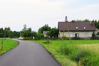
Leszczawka is a village in the administrative district of Gmina Bircza, within Przemyśl County, Subcarpathian Voivodeship, in south-eastern Poland. It lies approximately 8 kilometres (5 mi) south-west of Bircza, 31 km (19 mi) south-west of Przemyśl, and 53 km (33 mi) south-east of the regional capital Rzeszów.
Karbowo is a village in the administrative district of Gmina Brodnica, within Brodnica County, Kuyavian-Pomeranian Voivodeship, in north-central Poland. It lies approximately 5 kilometres (3 mi) north of Brodnica and 61 km (38 mi) north-east of Toruń.
Linowo is a village in the administrative district of Gmina Świecie nad Osą, within Grudziądz County, Kuyavian-Pomeranian Voivodeship, in north-central Poland. It lies approximately 5 kilometres (3 mi) south-west of Świecie nad Osą, 20 km (12 mi) south-east of Grudziądz, and 52 km (32 mi) north-east of Toruń.
Borowiec is a village in the administrative district of Gmina Łukowa, within Biłgoraj County, Lublin Voivodeship, in eastern Poland. It lies approximately 10 kilometres (6 mi) east of Łukowa, 31 km (19 mi) south-east of Biłgoraj, and 105 km (65 mi) south of the regional capital Lublin.
Lipie is a village in the administrative district of Gmina Radomsko, within Radomsko County, Łódź Voivodeship, in central Poland. It lies approximately 5 kilometres (3 mi) south-west of Radomsko and 83 km (52 mi) south of the regional capital Łódź.
Gronów is a village in the administrative district of Gmina Burzenin, within Sieradz County, Łódź Voivodeship, in central Poland. It lies approximately 10 kilometres (6 mi) south-west of Burzenin, 21 km (13 mi) south of Sieradz, and 66 km (41 mi) south-west of the regional capital Łódź.
Jankowice is a village in the administrative district of Gmina Babice, within Chrzanów County, Lesser Poland Voivodeship, in southern Poland. It lies approximately 4 kilometres (2 mi) south of Babice, 11 km (7 mi) south of Chrzanów, and 36 km (22 mi) west of the regional capital Kraków.
Łowiczki is a village in the administrative district of Gmina Zator, within Oświęcim County, Lesser Poland Voivodeship, in southern Poland. It lies approximately 4 kilometres (2 mi) south-west of Zator, 16 km (10 mi) south-east of Oświęcim, and 39 km (24 mi) west of the regional capital Kraków.
Piekło is a village in the administrative district of Gmina Końskie, within Końskie County, Świętokrzyskie Voivodeship, in south-central Poland. It lies approximately 9 kilometres (6 mi) south of Końskie and 31 km (19 mi) north-west of the regional capital Kielce.
Juliszew is a village in the administrative district of Gmina Słubice, within Płock County, Masovian Voivodeship, in east-central Poland. It lies approximately 7 kilometres (4 mi) north-west of Słubice, 20 km (12 mi) south-east of Płock, and 80 km (50 mi) west of Warsaw.
Łazy Leśne is a village in the administrative district of Gmina Kampinos, within Warsaw West County, Masovian Voivodeship, in east-central Poland. It lies approximately 4 kilometres (2 mi) north-west of Kampinos, 28 km (17 mi) west of Ożarów Mazowiecki, and 41 km (25 mi) west of Warsaw.
Podlasie is a village in the administrative district of Gmina Radziejowice, within Żyrardów County, Masovian Voivodeship, in east-central Poland.
Pogoń Lubstowska is a village in the administrative district of Gmina Ślesin, within Konin County, Greater Poland Voivodeship, in west-central Poland. It lies approximately 8 kilometres (5 mi) east of Ślesin, 19 km (12 mi) north-east of Konin, and 102 km (63 mi) east of the regional capital Poznań.
Owczegłowy is a village in the administrative district of Gmina Rogoźno, within Oborniki County, Greater Poland Voivodeship, in west-central Poland.
Poświętne is a settlement in the administrative district of Gmina Szamotuły, within Szamotuły County, Greater Poland Voivodeship, in west-central Poland. It lies approximately 13 kilometres (8 mi) west of Szamotuły and 39 km (24 mi) north-west of the regional capital Poznań.
Brzękowice Górne is a village in the administrative district of Gmina Psary, within Będzin County, Silesian Voivodeship, in southern Poland.
Tebowizna is a village in the administrative district of Gmina Lipnica, within Bytów County, Pomeranian Voivodeship, in northern Poland. It lies approximately 9 kilometres (6 mi) north-west of Lipnica, 17 km (11 mi) south-west of Bytów, and 95 km (59 mi) west of the regional capital Gdańsk.

The Bückeberg is a hill that lies south of Hamelin on the eastern perimeter of the Weser village of Hagenohsen which is on the right-hand, eastern bank of the River Weser in central Germany.


