This page is based on this
Wikipedia article Text is available under the
CC BY-SA 4.0 license; additional terms may apply.
Images, videos and audio are available under their respective licenses.

East Blythe is a former census-designated place (CDP) and unincorporated community in Riverside County, California, United States. The 2000 census population was three.

Anza-Borrego Desert State Park (ABDSP) is a California state park located within the Colorado Desert of southern California, United States. The park takes its name from 18th century Spanish explorer Juan Bautista de Anza and borrego, the Spanish word for sheep. With 600,000 acres (240,000 ha) that includes one-fifth of San Diego County, it is the largest state park in California.

The Chocolate Mountains of California are located in Imperial and Riverside counties in the Colorado Desert of Southern California. The mountains stretch more than 60 miles (100 km) in a northwest to southeast direction, and are located east of the Salton Sea and south and west of the Chuckwalla Mountains and the Colorado River. To the northwest lie the Orocopia Mountains.

Chiriaco Summit is a small unincorporated community and travel stop located along Interstate 10 in the Colorado Desert of Southern California. It lies 19 miles (31 km) west of Desert Center on the divide between the Chuckwalla Valley and the Salton Sea basin at an elevation of 1,706 feet (520 m).
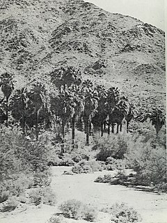
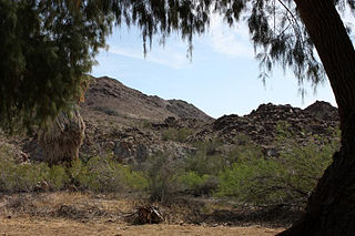
Corn Springs is a palm oasis situated in the Chuckwalla Mountains of the Colorado Desert in Riverside County, California, United States, seventeen miles southeast of Desert Center. Native Americans relied on the springs, and they engraved many petroglyphs on the rocks in the area. In the late 19th century, miners in the area also relied on the springs, and they established the Corn Springs Mining District in 1897.

The Palen Mountains are located in the southern Mojave Desert – northern Colorado Desert in eastern Riverside County, California, USA. The range lies southeast of the Coxcomb Mountains, and northeast of the Chuckwalla Mountains near Interstate 10. The mountains lie in a southwest-northeasterly direction, and are approximately 15 miles long and nine miles wide at their widest point.

The Orocopia Mountains are located in Riverside County in southern California, United States, east of the Coachella Valley, west of the Chuckwalla Mountains, and south of Interstate 10 in the Colorado Desert. The range lies in an east-west direction, and is approximately 18 miles long. The Orocopia Mountains are north of and overlooking the Salton Sea and south of Joshua Tree National Park, with the Chocolate Mountains to the southeast and the scenic Mecca Hills just northwest.
The McCoy Mountains are located in southeastern California in the United States. The southeast terminus of the range lies adjacent the western edge of the Parker Valley in a southern stretch of the Lower Colorado River Valley corridor.
The Mule Mountains of California are located in the southeastern part of the state in the United States. The range lies in a northeast-southwesterly direction south of the McCoy Mountains and west of the Palo Verde Valley and Colorado River. The mountain range is approximately 18 miles (29 km) long and is located just south of Interstate 10, about 5 mi (8 km) southeast of Chuckawalla Valley State Prison. The northern end of the range is in Riverside County, and the southern end is in Imperial County. Downtown Blythe, California is about 12 mi (19 km) to the northeast.

Sauromalus ater is a species of lizard in the family Iguanidae. It inhabits the Sonoran and Mojave Deserts of the Southwestern United States and northwestern Mexico. Its range extends from eastern California, Utah, and Nevada south to Baja California and Sonora.

The Mecca Hills are a low mountain range located in Riverside County, southern California, in the United States.
San Felipe Creek is a stream in Imperial and San Diego Counties of California. It arises in the Volcan Mountains of San Diego County 33°11′57″N 116°37′35″W, and runs eastward, gathering the waters of most of the eastern slope of the mountains and desert of the county before it empties into the Salton Sea. It is probably the last remaining perennial natural desert stream in the Colorado Desert region.
The Rice Valley is a valley of the southeastern Mojave Desert, located within Riverside County, California.

The Chuckwalla Valley is a large valley in eastern Riverside County, California, named for a large lizard, the chuckwalla found in the arid Southwestern United States deserts.