
The Chilcotin Group, also called the Chilcotin Plateau Basalts, is a large area of basaltic lava that forms a volcanic plateau running parallel with the Garibaldi Volcanic Belt in south-central British Columbia, Canada.
Lava Fork is a creek in northwestern British Columbia, Canada and of the Alaska Panhandle, United States. It lies west of the Unuk River and northwest of Stewart. It flows south from the Lava Lakes across the British Columbia-Alaska border into the Blue River in the extreme northern part of Misty Fjords National Monument.

The Alligator Lake volcanic complex is a group of basaltic cinder cones and lava flows in south central Yukon. The upper part of the Alligator Lake volcanic complex consists of two well-preserved cinder cones capping a small shield volcano. They probably post-date the local Holocene glaciation. Lava flows from both cinder cones traveled to the north and were erupted simultaneously. Their compositions range from alkali olivine basalt to basanitic. Lava flows from the northeast cone are the largest extending 6 km (4 mi) from the cone and expanding to a width of 10 km (6 mi) at the terminus.

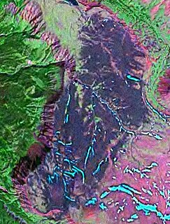
The Atlin Volcanic Field, also called the Llangorse Volcanic Field and the Surprise Lake Volcanic Field, is a group of late-Pleistocene to Holocene cinder cones that lies on the Teslin Plateau east of Atlin Lake, Canada. The largest volcanic feature is the 1880-m-high Ruby Mountain which has been partially dissected by Pleistocene and post-Wisconsin glaciation. Two basaltic cinder cones at the heads of Cracker Creek and Volcanic Creek lie within glacially dissected U-shaped valleys and may be of postglacial age.
Volcanic Creek Cone is a small cinder cone 20 kilometres northeast of Atlin in northwestern British Columbia. There are two cinder cones and a lava flow at least 3 kilometres long which is present below parts of the tree covered area. The subdued form of Volcanic Creek cone is visible directly below the largest snow patch. The cone has probably suffered through at least one glacial episode. Volcanic Creek cone is part of the Northern Cordilleran Volcanic Province.
Cracker Creek Cone is a small cinder cone in northwestern British Columbia. A large lava flow that partly filled Ruby Creek may have originated from this cone. The lower west side of the cone appears to be partly covered by glacial till suggesting that the cone is older than the most recent glacial advances down Ruby Creek. Cracker Creek Cone is in the Northern Cordilleran Volcanic Province and is one of the three young volcanic cones in the Atlin Volcanic Field.
The Iskut-Unuk River Cones are a group of eight small basaltic centres at the southern end of the Northern Cordilleran Volcanic Province in the Boundary Ranges of the Coast Mountains, in western North America. The lava flows date back 70,000 years, but the subaerial vents produced cinder cones and lava flows that were probably all active between about 9,000 and a few hundred years ago. The last lava flows were erupted from The Volcano about 150 years ago. Iskut Canyon Cone produced at least 10 thick lava flows which initially dammed the Iskut River.

Volcano Mountain is a cinder cone in central Yukon Territory, Canada, located a short distance north of Fort Selkirk, near the confluence of the Pelly and Yukon Rivers. Volcano Mountain is called Nelrúna in the Northern Tutchone language.
The Desolation Lava Field is a volcanic field associated with the Mount Edziza volcanic complex in British Columbia, Canada. It covers 150 km2 (58 sq mi) on the northern end of the Mount Edziza volcanic complex and is the largest area of the youngest lava flows. The longest lava flow from the field and the volcanic complex, is about 12 km (7.5 mi) long. Eve Cone, in the middle of the field, is one of the most symmetrical and best preserved cinder cones in Canada.

The Tseax Cone, also called the Tseax River Cone or the Aiyansh Volcano, is a young cinder cone and adjacent lava flows associated with the Nass Ranges and the Northern Cordilleran Volcanic Province. It is located east of Crater Creek at outlet of Melita Lake, southeast of Gitlakdamix and 60 kilometres (37 mi) north of Terrace, British Columbia, Canada.
Gabrielse Cone is a remarkably fresh, clearly postglacial monogenetic cinder cone, located in the Tuya Volcanic Field in British Columbia, Canada. It is about 400 m (1,312 ft) in diameter and has a central crater about 30 m (98 ft) deep. It is Holocene in age and to its northeast appears to be breached with the remnants of a lava flow. The cone is near the headwaters of Iverson Creek.
Ibex Mountain is a young cinder cone in the Yukon Territory, Canada, located 33 km southwest of Whitehorse and 12 km southeast of Mount Arkell. It is in a group of basaltic cones and lava flows called Alligator Lake and is in the Northern Cordilleran Volcanic Province. It is believed Ibex Mountain last erupted during the Pleistocene. Ibex Mountain is at the head of the Ibex River, which is southeast of Whitehorse. There is a road that runs close to Ibex Lake on the southeast side of the summit. From there is the hike to the summit of the cone.
The Thumb is a mountain located 7 km (4 mi) south of Sitchiada Mountain on the east side of Bear Lake, on the divide between the upper Omineca River and the basin of the Bear River in the Omineca Country of the Central-North Interior of British Columbia, Canada. As the Omineca is part of the Arctic Ocean drainage, via the Peace and Mackenzie Rivers, and the Bear is in the basin of the Skeena River, which drains to the Pacific, The Thumb is located on the Continental Divide.
Fort Selkirk Vent is a geological name for a cinder cone in central Yukon, Canada, located just east of Fort Selkirk along the Yukon River.
The Mess Lake Lava Field is a volcanic field associated with the Mount Edziza volcanic complex of the Northern Cordilleran Volcanic Province in northwestern British Columbia, Canada. It lies northwest of the Spectrum Range on the Kitsu Plateau and consists of young basaltic lava flows and tephra. The source for the basaltic lava and tephra was three cinder cones, including Mess Lake Cone and The Ash Pit, which may be the youngest volcanic feature of the Mount Edziza volcanic complex.
Mess Lake Cone is a cinder cone in northwestern British Columbia, Canada. It is polygenetic in nature, having erupted more than once throughout its eruptive history. Mess Lake Cone is one of the volcanoes that produced young basaltic lava flows in the central portion of the Mount Edziza volcanic complex in the past 10,000 years. These basaltic lava flows form a north-south trending volcanic field called the Mess Lake Lava Field.
Walkout Creek Cone is a cinder cone in northwestern British Columbia, Canada. It is one of the volcanoes that produced young basaltic lava flows in the central portion of the Mount Edziza volcanic complex in the past 10,000 years. These basaltic lava flows form a volcanic field called the Snowshoe Lava Field.

The volcanic history of the Northern Cordilleran Volcanic Province presents a record of volcanic activity in northwestern British Columbia, central Yukon and the U.S. state of easternmost Alaska. The volcanic activity lies in the northern part of the Western Cordillera of the Pacific Northwest region of North America. Extensional cracking of the North American Plate in this part of North America has existed for millions of years. Continuation of this continental rifting has fed scores of volcanoes throughout the Northern Cordilleran Volcanic Province over at least the past 20 million years and occasionally continued into geologically recent times.


