| Look up circumpolar in Wiktionary, the free dictionary. |
Circumpolar may refer to:
- Antarctic region
- Antarctic Circle
- the Antarctic Circumpolar Current
- Subantarctic
- List of Antarctic and subantarctic islands
- Antarctic Convergence
- Antarctic Circumpolar Wave
- Antarctic Ocean

The Antarctic Convergence or Antarctic Polar Front is a curve continuously encircling Antarctica, varying in latitude seasonally, where cold, northward-flowing Antarctic waters meet the relatively warmer waters of the subantarctic. Antarctic waters predominantly sink beneath subantarctic waters, while associated zones of mixing and upwelling create a zone very high in marine productivity, especially for Antarctic krill. This line, like the arctic tree line, is a natural boundary rather than an artificial one like a line of latitude. It not only separates two hydrological regions, but also separates areas of distinctive marine life associations and of different climates. There is no Arctic equivalent, due to the amount of land contiguous with the northern polar region.
The Antarctic Circumpolar Wave (ACW) is a coupled ocean/atmosphere wave that circles the Southern Ocean in approximately eight years at 6–8 cm/s (2.4–3.1 in/s). Since it is a wave-2 phenomenon at each fixed point in space a signal with a period of four years is seen. The wave moves eastward with the prevailing currents.
- Arctic region
- Arctic Circle
- Subarctic
- Circumpolar peoples
- Arctic Cooperation and Politics
- Arctic Ocean
- List of islands in the Arctic Ocean

The Arctic Circle is one of the two polar circles and the most northerly of the five major circles of latitude as shown on maps of Earth. It marks the northernmost point at which the centre of the noon sun is just visible on the December solstice and the southernmost point at which the centre of the midnight sun is just visible on the June solstice. The region north of this circle is known as the Arctic, and the zone just to the south is called the Northern Temperate Zone.

The subarctic is a region in the Northern Hemisphere immediately south of the true Arctic and covering much of Alaska, Canada, Iceland, the north of Scandinavia, Siberia, the Shetland Islands, and the Cairngorms. Generally, subarctic regions fall between 50°N and 70°N latitude, depending on local climates. Precipitation is low, and vegetation is characteristic of the taiga.

Circumpolar peoples and Arctic peoples are umbrella terms for the various indigenous peoples of the Arctic.
- Circumpolar constellation, a constellation that never rises or sets from the perspective of a given latitude on Earth
- Circumpolar star, a star that never rises or sets from the perspective of a given latitude on Earth
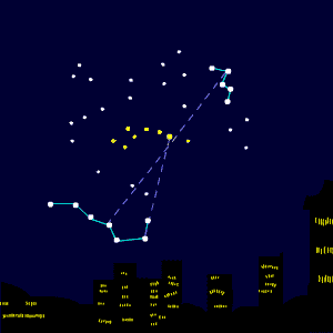
A circumpolar star is a star, as viewed from a given latitude on Earth, that never sets below the horizon due to its apparent proximity to one of the celestial poles. Circumpolar stars are therefore visible from said location toward the nearest pole for the entire night on every night of the year.
- Polar front in meteorology
- circumpolar navigation, a global circumnavigation which traverses both poles

The Antarctic Circle is the most southerly of the five major circles of latitude that mark maps of the Earth. The region south of this circle is known as the Antarctic, and the zone immediately to the north is called the Southern Temperate Zone. South of the Antarctic Circle, the sun is above the horizon for 24 continuous hours at least once per year and the centre of the sun is below the horizon for 24 continuous hours at least once per year ; this is also true within the equivalent polar circle in the Northern Hemisphere, the Arctic Circle.
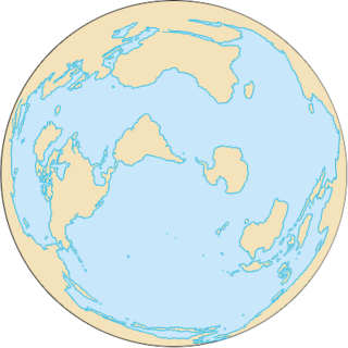
The Antarctic Circumpolar Current (ACC) is an ocean current that flows clockwise from west to east around Antarctica. An alternative name for the ACC is the West Wind Drift. The ACC is the dominant circulation feature of the Southern Ocean and has a mean transport estimated at 100-150 Sverdrups, or possibly even higher, making it the largest ocean current. The current is circumpolar due to the lack of any landmass connecting with Antarctica and this keeps warm ocean waters away from Antarctica, enabling that continent to maintain its huge ice sheet.

The Subantarctic is a region in the southern hemisphere, located immediately north of the Antarctic region. This translates roughly to a latitude of between 46° and 60° south of the Equator. The subantarctic region includes many islands in the southern parts of the Indian Ocean, Atlantic Ocean and Pacific Ocean, especially those situated north of the Antarctic Convergence. Subantarctic glaciers are, by definition, located on islands within the subantarctic region. All glaciers located on the continent of Antarctica are by definition considered to be Antarctic glaciers.