
The North Bay is a subregion of the San Francisco Bay Area, in California, United States. The largest city is Santa Rosa, which is the fifth-largest city in the Bay Area. It is the location of the Napa and Sonoma wine regions, and is the least populous and least urbanized part of the Bay Area. It consists of Marin, Napa, Solano and Sonoma counties.

The Episcopal Diocese of California is an ecclesiastical territory or diocese of the Episcopal Church in the United States of America (ECUSA) in Northern California. The founding Episcopal diocese in the state, once encompassing all of California, today the diocese comprises Alameda, Contra Costa, Marin, San Francisco, and San Mateo Counties, and the cities of Los Altos and part of Palo Alto in Santa Clara County, in the San Francisco Bay Area. The see city is San Francisco, California and the diocesan cathedral is Grace Cathedral on top of Nob Hill.
The Contra Costa Community College District is a community college district that encompasses three community colleges in Contra Costa County, California - Contra Costa College, Diablo Valley College and Los Medanos College. The headquarters is in the George R. Gordon Education Center in Martinez, California.
KRSH is a commercial radio station in Healdsburg, California, broadcasting to the Santa Rosa, California, area on 95.9 FM.
KFGY is a commercial radio station licensed to Healdsburg, California, broadcasting to the Santa Rosa, California area on 92.9 FM. Its programming is also broadcast on translator K300AO at 107.9 MHz, licensed to Santa Rosa.

KVRV is a commercial radio station licensed to Monte Rio, California, broadcasting to the Santa Rosa, California area.
KHTH-FM is a commercial radio station in Santa Rosa, California, broadcasting on 101.7 FM. It is owned by Lawrence Amaturo, through licensee
Grizzly Bay is a baylet of the San Francisco Bay which dips into Solano County, California and borders Suisun Bay. Grizzly Bay is home to many sloughs and wildlife areas in addition to the Fifth Reserve Fleet which is docked off the coast of Benicia.
Pacheco Creek is a 3.4-mile-long (5.5 km) waterway in central Contra Costa County, California. It empties into Suisun Bay.
Seal Islands are a pair of islands in Suisun Bay at the mouth of the Sacramento-San Joaquin River Delta in Contra Costa County, California, 10 km east of Benicia, and 500 metres off-shore from the former Concord Naval Weapons Station and Port Chicago Naval Magazine.

The Episcopal Diocese of Northern California, created in 1910, is the diocese of the Episcopal Church in the United States of America with jurisdiction over the northern part of California. It is in Province 8 and its cathedral, Trinity Episcopal Cathedral, is in Sacramento, as are the diocesan offices.

Cadenasso is an unincorporated community in Yolo County, California, between two other unincorporated communities: Brooks and Capay. Cadenasso lies at an elevation of 325 feet. The settlement is named after Nicola Cadenasso, a rancher who came from Genoa, Italy in the late 19th century. A post office was run in the town between 1894–95 and again in 1915–18.
Hylaeamys oniscus, the sowbug rice rat, is a rodent species in the genus Hylaeamys of family Cricetidae. It was formerly placed in the genus Oryzomys as Oryzomys oniscus.

Ohmer is a former settlement in Contra Costa County, California. It was located on the Oakland, Antioch and Eastern Railroad 6 miles (10 km) east of Martinez, at an elevation of 62 feet. It still appeared on maps as of 1947.
Melita is a former settlement in Alameda County, California, United States. It was located 3.5 miles (5.6 km) southwest of Brooklyn. A post office operated in Melita from 1869 to 1871.
Seahaven is an unincorporated community in Marin County, California. It lies at an elevation of 177 feet and is located at 38°06′40″N 122°52′14″W.
The Middletown Rancheria of Pomo Indians of California is a federally recognized tribe of Pomo Indians, as well as some Wappo and Lake Miwok Indians, in California, headquartered in Middletown, California.

Estero de Limantour State Marine Reserve (SMR) and Drakes Estero State Marine Conservation Area (SMCA) are two adjoining marine protected areas along the Point Reyes National Seashore in Marin County on California’s north central coast. These marine protected areas cover a combined 4.04 square miles (10.5 km2), with 1.49 square miles (3.9 km2) in the SMR and 2.55 square miles (6.6 km2) in the SMCA. Drakes Estero SMCA prohibits the take of all living marine resources from Drakes Estero except the recreational take of clams and formerly the commercial aquaculture of shellfish pursuant to a disputed state water bottom lease and permit, which has been the subject of ongoing legal proceedings since 2012, when the lease was allowed to expire.
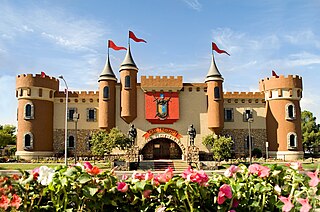
Golfland Entertainment Centers are a chain of family amusement centers, miniature golf courses, and water parks located in California and Arizona. The company was founded in 1953.
Putah Creek Wildlife Area is a state wildlife area of Solano County, California. The 670 acre reserve lies to the southeast of Lake Berryessa, to the south of Monticello Dam and the confluence of Putah Creek and Cold Creek. Trees found here include cottonwood, blue oak and chaparral. Deer, quail, California towhee, Bullock's oriole, and black-headed grosbeak are also found in the area, which also includes Stebbins Cold Canyon Reserve.


