Related Research Articles

Modoc Point is a cliff on the east shore of Upper Klamath Lake, in Klamath County, Oregon, United States, approximately 15 miles north of Klamath Falls on U.S. Route 97. It is part of the larger cliff known as Modoc Rim or Modoc Ridge.

Mount Hood is an unincorporated community and census-designated place (CDP) in Hood River County, Oregon, United States, about 3 miles (5 km) northeast of Parkdale on Oregon Route 35. As of the 2010 census it had a population of 286. Mount Hood is the terminus of Oregon Route 281, the Hood River Highway.

Tumalo Creek is a tributary, about 20 miles (32 km) long, of the Deschutes River, located in Deschutes County in Central Oregon, United States. It rises in the Cascade Range at 44.04706°N 121.598647°W, where Middle Fork Tumalo Creek and North Fork Tumalo Creek meet, and forms several waterfalls, including the 97-foot (30 m) Tumalo Falls. Its mouth is on the Deschutes at 44.1159506°N 121.3394783°W.
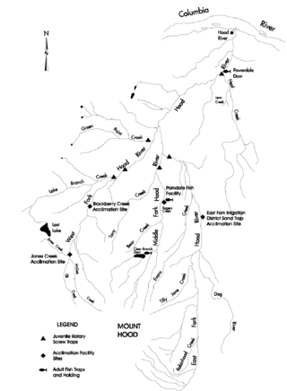
The Dog River is a small river in Oregon's Cascade Range and drains a few eastern foothills of Mount Hood. It is a tributary of East Fork Hood River and also contributes water for The Dalles and Hood River water systems. It is approximately 8 miles (14 km) long and drains the most southeastern portion of the Hood River watershed.

Ortley is a former town in Wasco County, Oregon, in the United States. It was about 1 mile (2 km) south of Rowena and about 7 miles (11 km) southeast of Mosier; the site is now on private land and no evidence of the townsite exists today. It is still classed as a populated place by the USGS.

Bull Run is an unincorporated community in Clackamas County, Oregon, United States. It is located about 5 miles (8.0 km) northeast of Sandy, near the Bull Run River and the powerhouse of the defunct Mount Hood Railway and Power Company.
Dee is an unincorporated community and former company town in Hood River County, Oregon, United States, on Oregon Route 281, about 11 miles south of Hood River.
Pine Grove is an unincorporated community in Hood River County, Oregon, United States on Oregon Route 35 in the middle Hood River Valley near Neal Creek. It is about five miles south of the city of Hood River and has a Hood River ZIP code.

Cazadero is an unincorporated historic locale in Clackamas County, Oregon, United States. Cazadero was a station on the Estacada interurban railway line of the Portland Railway, Light and Power Company (PRL&P) and later Portland Electric Power Company (PEPCO), near where the power plant of the PEPCO-owned Cazadero Dam was located on the Clackamas River.
Lenz is an unincorporated community in Hood River County, Oregon, United States just west of Oregon Route 35 about a mile and a half east of Odell. This station on the Mount Hood Railroad was named after John Lenz, an early settler. Lenz Butte and Lenz Creek are nearby. The name of the station has also been spelled Lentz and was also known as "Sherman Spur". The elevation is 732 feet.
Modoc Point is an unincorporated community in Klamath County, Oregon, United States on U.S. Route 97 on the shore of Upper Klamath Lake.

Olney is an unincorporated community and former company town in Clatsop County, Oregon, United States, on Oregon Route 202 approximately eight miles south of Astoria. Olney is located at 46.100109°N 123.757637°W. Its post office is assigned ZIP code 97325.
Wyeth is an unincorporated locale in Hood River County, Oregon, United States. It is the site of a campground area in the Columbia River Gorge National Scenic Area off Interstate 84 (I-84).
Necanicum is an unincorporated community in Clatsop County, Oregon, United States. It is located approximately 13 miles southeast of Seaside on U.S. Route 26 in the Northern Oregon Coast Range, next to the Necanicum River. Necanicum Junction is about a mile east of the site of the former post office, at the intersection of U.S. 26 and Oregon Route 53. It is served by the Seaside post office.
Hamlet is an unincorporated community in Clatsop County, Oregon, United States. It is located approximately six miles southeast of Necanicum, in the Northern Oregon Coast Range near the confluence of the North Fork Nehalem River and the Little North Fork Nehalem River. It is surrounded by units of the Clatsop State Forest.

Fairbanks is an unincorporated community in Wasco County, Oregon, United States. It is about 12 miles (19 km) east of The Dalles, just south of U.S. Route 30/Interstate 84, near Fifteenmile Creek.
Bloucher is an unincorporated historic community west of Odell in Hood River County, Oregon, United States.
Jonesboro is an unincorporated historic community in Malheur County, Oregon, United States. It is located on U.S Route 20, between Juntura and Harper, near the Malheur River.
Clifton is an unincorporated community in Clatsop County, Oregon, United States. It is located north of U.S. Route 30, about nine miles northwest of Westport on the south bank of the Columbia River. It is on Clifton Channel across from Tenasillahe Island.
Faubion is an unincorporated community in Clackamas County, Oregon, United States. It is located about 2 miles northwest of Rhododendron, in the Mount Hood Corridor on a loop road off U.S. Route 26 near the Zigzag River.
References
- ↑ "Clifton". Geographic Names Information System . United States Geological Survey, United States Department of the Interior. November 28, 1980. Retrieved October 27, 2015.
- ↑ Oregon Atlas & Gazetteer (7th ed.). Yarmouth, Maine: DeLorme. 2008. p. 24. ISBN 0-89933-347-8.
- 1 2 McArthur, Lewis A.; McArthur, Lewis L. (2003) [1928]. Oregon Geographic Names (7th ed.). Portland, Oregon: Oregon Historical Society Press. p. 210. ISBN 978-0875952772.