
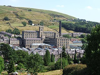
Golcar is a village on a hillside crest above the Colne Valley in West Yorkshire, England, 2.5 miles (4 km) west of Huddersfield, and just north of the River Colne and the Huddersfield Narrow Canal.

Kirklees is a local government district of West Yorkshire, England, governed by Kirklees Council with the status of a metropolitan borough. The largest town and administrative centre of Kirklees is Huddersfield, and the district also includes Batley, Birstall, Cleckheaton, Denby Dale, Dewsbury, Heckmondwike, Holmfirth, Kirkburton, Marsden, Meltham, Mirfield and Slaithwaite. Kirklees had a population of 422,500 in 2011; it is also the third largest metropolitan district in England by area size, behind Doncaster and Leeds.

Linthwaite is a village in Kirklees, West Yorkshire, England. Historically part of the West Riding of Yorkshire, it is situated 4 miles (6.4 km) west of Huddersfield, on the A62 in the Colne Valley. The village together with Blackmoorfoot had a population of 3,835 according to the 2001 census.
Marsden is a large village in the Metropolitan Borough of Kirklees, West Yorkshire, England. It is in the South Pennines close to the Peak District which lies to the south. The village is 7 miles (11 km) west of Huddersfield at the confluence of the River Colne and Wessenden Brook. It was an important centre for the production of woollen cloth. In 2020, the village had an estimated population of 3,768.

Meltham is a town and civil parish within the Metropolitan Borough of Kirklees, in West Yorkshire, England. It lies in the Holme Valley, below Wessenden Moor, four and a half miles south-west of Huddersfield on the edge of the Peak District National Park. It had a population of 8,089 at the 2001 census, which was estimated to have increased to 8,600 by 2005. The population assessed at the 2011 Census was 8,534. It has 12 elected council members who meet up around every 6 weeks.

Slaithwaite, locally Slawit, is a village within the Metropolitan Borough of Kirklees, in West Yorkshire, England. Historically part of the West Riding of Yorkshire, it lies in the Colne Valley, lying across the River Colne and the Huddersfield Narrow Canal, approximately 5 miles (8 km) south-west of Huddersfield. The village has two primary schools; Slaithwaite Church of England School on Holme Lane and Nields Junior, Infant and Nursery School on Nields Road. There is also a small primary school in the nearby hamlet of Wilberlee. The village is serviced by the local Secondary School, Colne Valley High School in Linthwaite approximately 2.5 miles away. The village was voted the best place to live in the North & Northeast in The Times 2022 Best Places To Live annual guide.

Huddersfield is a market town in the Kirklees district in West Yorkshire, England. It is the administrative centre and largest settlement in the Kirklees district. The town is in the foothills of the Pennines. The River Holme's confluence into the similar-sized Colne to the south of the town centre which then flows into the Calder in the north eastern outskirts of the town.

The Huddersfield Narrow Canal is an inland waterway in northern England. It runs just under 20 miles (32 km) from Lock 1E at the rear of the University of Huddersfield campus, near Aspley Basin in Huddersfield, to the junction with the Ashton Canal at Whitelands Basin in Ashton-under-Lyne. It crosses the Pennines by means of 74 locks and the Standedge Tunnel.

The Huddersfield Broad Canal or Sir John Ramsden's Canal, is a wide-locked navigable canal in West Yorkshire in northern England. The waterway is 3.75 miles (6 km) long and has 9 wide locks. It follows the valley of the River Colne and connects the Calder and Hebble Navigation at Cooper Bridge junction with the Huddersfield Narrow Canal near Aspley Basin in Huddersfield.

The River Colne in West Yorkshire is formed at the confluence of two brooks that originate in the Pennines close to Marsden. It flows in an easterly direction through the Colne Valley and Huddersfield towards Cooper Bridge where it flows into the River Calder.

Colne Valley is a constituency represented in the House of Commons of the UK Parliament since 2019 by Jason McCartney of the Conservative Party.

Crosland Moor is a district of the town of Huddersfield, West Yorkshire, England.

Milnsbridge is a district of Huddersfield, West Yorkshire, England, situated 2 miles (3 km) west of the town centre, and in the Colne Valley. The name is said to have derived from the water-powered mill and the bridge that stood alongside it in the 13th century.

Longroyd Bridge is a suburb approximately 1200 yds (1.1 km) to the southwest of Huddersfield town centre, West Yorkshire, England. The area is composed of industrial and commercial units. There is little housing in the commercial area, though within a few hundred yards are the housing areas of Thornton Lodge and Paddock.

The Huddersfield and District Association League is a football competition based in the area of Huddersfield, England. It was founded in 1898. The league has a total of four senior divisions and four reserve divisions. The highest senior division, Division One, sits at level 14 of the English football league system and is a feeder to the West Yorkshire and Yorkshire Amateur Leagues. The reserve divisions are not part of the league system.
Standedge is a moorland escarpment in the Pennine Hills of northern England between Marsden, West Yorkshire and Diggle, Greater Manchester. Standedge has been a major moorland crossing point since Roman times and possibly earlier.

The South Pennines is a region of moorland and hill country in northern England lying towards the southern end of the Pennines. In the west it includes the Rossendale Valley and the West Pennine Moors. It is bounded by the Greater Manchester conurbation in the west and the Bowland Fells and Yorkshire Dales to the north. To the east it is fringed by the towns of West Yorkshire whilst to the south it is bounded by the Peak District. The rural South Pennine Moors constitutes both a Site of Special Scientific Interest and Special Area of Conservation.
Colne Valley was an urban district in the West Riding of Yorkshire, England between 1937 and 1974. It takes its name from the River Colne which rises above the town of Marsden and flows eastward towards Huddersfield.

Nettleton Hill is a hamlet in the unparished area of Huddersfield, in the Kirklees district in the English county of West Yorkshire. It is situated near the town of Huddersfield, north of Scapegoat Hill and south of Pighill Wood. Longwood reservoir is to the east of the settlement. Nettleton Hill is part of the Golcar ward and of the HD7 postcode district.
