September5, 1917;106 years ago(1917-09-05) (Sea Beach)[2] December23, 1918;105 years ago(1918-12-23) (West End)[3] May29, 1919;104 years ago(1919-05-29) (Brighton; formal opening)[3] May1, 1920;103 years ago(1920-05-01) (Culver)[3]
Stops rush hours in the peak direction only (limited service)
Stops weekdays and weekday late nights
The Coney Island–Stillwell Avenue station (also known as Coney Island Terminal and signed on some trains as either Coney Island or Stillwell Avenue) is a New York City Subwayterminal in Coney Island, Brooklyn. It is the railroad-south terminus for the D, F, N, and Q trains at all times and for the <F> train during rush hours in the peak direction.
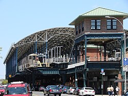
Coney Island–Stillwell Avenue has eight tracks and four island platforms, with trains entering from both compass north and south. Opened in 1919–20, the large facility was designed at a time when Coney Island was the primary summer resort area for the New York metropolitan area, with all of the rail lines in southern Brooklyn funneling service to the area. The station has seen many service patterns throughout its history, and was completely renovated from 2001 to 2004.
The station is located at the corner of Stillwell and Surf Avenues in Coney Island, the site of the former West End Terminal. Geographically, the station is the southernmost terminal in the New York City Subway system. In addition, it is one of the largest elevated transportation terminals in the world.
These railroads were not all connected to each other, resulting in a series of spur lines crossing the island.[10] However, the Brighton, Culver, Sea Beach, and West End railroads were acquired by the Brooklyn Rapid Transit Company (BRT) by the late 1890s, and the Dual Contracts, signed in 1913, allowed many more subway lines to be built within New York City, which had been incorporated fifteen years prior.[12][14]
New West End Terminal
The station platform before its 2000s renovationNortheast view of the signal tower at the southern end of the station, as seen from Stillwell Avenue near Surf Avenue
In the late 1910s, a completely reconstructed New West End Terminal station (which gradually became better known as Coney Island Terminal station) was built on an elevated structure. The new terminal unified the terminals of most of the former steam railroad lines terminating at Coney Island,[15] aside from the Long Island Rail Road-controlled New York and Manhattan Beach Railway.[14] This new terminal could accommodate hundreds of thousands of passengers a day.[15] This project entailed rerouting the Brighton and Culver Lines from a ground-level alignment to an elevated structure with eight tracks and four platforms.[14]
The BRT-operated Sea Beach Line, which served the terminal, opened on September 5, 1917,[2] and the BRT West End Line had been similarly inaugurated on December 23, 1918.[3][14] The terminal officially opened on May 29, 1919, when the new Brighton Line opened.[3][14][15][16] With the opening of the Culver Line on May 1, 1920, the terminal was finally completed.[3][17][18][19]
As a result of the Culver Line extension, the BRT's double fare to Coney Island expired, and was cut from 10 cents to 5 cents,[18][19] and Coney Island became a more affordable vacation area compared to in previous years. In 1923, these lines came under the control of the Brooklyn–Manhattan Transit Corporation (BMT), the BRT's successor company.[3] Riders at the new station were promised trains that ran every three minutes during rush hours, but this quickly proved not to be true. In 1923, a reporter for the Brooklyn Standard Union observed that rush hour trains had headways of eight minutes on the Sea Beach Line and fifteen minutes on the West End Line, and that no direct Manhattan service was being run on either the Brighton or Culver Lines during rush hours.[20]
In 1929, the BMT announced a new entrance for the station. This new entrance would have retail space that would be "periodically inspected."[21] In June 1933, a new Brighton–Franklin weekday service was announced. This service would operate express (except in evening rush hours) providing a direct route from Franklin Avenue to Coney Island. Culver elevated trains would operate to either Sands Street or Park Row depending on the time of day.[22]
There was a transfer from the Coney Island Terminal to the Norton's Point Trolley to Sea Gate, via an elevated footbridge across Stillwell Avenue to the elevated trolley station.[8] In 1948, the trolley was discontinued and replaced with the B74 Mermaid Avenue Bus,[23] The trolley ramp spanning Stillwell Avenue and West 15th Street was torn down around this time.[24]
Matters became more complicated in 1954, when the Independent Subway System (IND) started operating D trains on the Culver Line.[25] At the time, the tracks had lettered names (i.e. Track A, Track B, all the way to Track H from east to west). However, the IND also used lettered designations for its routes (i.e. A, B, all the way to H as well).[26] The BMT had used numbered route designations up to this point, so this had not been a problem. However, the D route was now using the Culver Line, which departed from tracks E and F. To avoid confusion, the tracks were given numbered designations.[26]
In 1956, residents of Coney Island protested against paying a transfer to the bus on Mermaid Avenue (now the B74 bus to Sea Gate), with some saying that the 15-cent fee for transferring should be abolished because the bus was essentially an adjunct to the station.[27] In 1979, the City Planning Commission proposed something similar, in that Coney Island residents would get a free transfer between the B36/B74 bus routes and the subway station.[28] It was noted that the station was the only one that did not get a free bus transfer after the corresponding subway transfer was discontinued (in sharp contrast to the BMT Culver Line, BMT Myrtle Avenue Line, and IRT Third Avenue Line, which were discontinued but replaced by bus transfers). The free transfers would allow a $200 million apartment complex nearby, funded by the government, to get more residents to move in, as well as diversify Mark Twain Junior High School and attract a stable middle class.[28] The experimental free transfer was instituted in November 1980, following three years of continuous advocacy by a Coney Island tenants' group. At the time, subway and bus fares were separate and cost a combined $1.20. The first phase of the program allowed riders to transfer for free, paying a 60-cent combined fare, while the second phase allowed for a half-price transfer, with the combined fare being 90 cents.[29] Schedules showing trains' departure times were installed at the Coney Island Terminal in 1965.[30]
Station renovation
Main Departure Board
Once a grand hub, the Coney Island Terminal had started deteriorating by the 1960s.[8] By 1980, the entire system was in a state of disrepair, and the terminal was no exception. It was slated to be rebuilt that year. According to the New York Daily News, the renovated station would get "a bright, new airy look" as well as one of the system's first installations of continuously welded rail.[31] The steel and concrete station was badly corroded by the effects of salt water and poor maintenance.[32] In 1983, the MTA added funding for a renovation of the Stillwell Avenue station to its 1980–1984 capital plan.[33]The New York Times wrote in 2008: "The old station was a gaping masterpiece of stalactited decrepitude [...] nicely mirroring the seedy ambience of the Coney Island Boardwalk."[34]
Initial renovation attempts
Plans to renovate the Coney Island–Stillwell Avenue station were brought up again in the late 1980s, after restaurant mogul Horace Bullard proposed rebuilding the nearby Steeplechase Park.[35] The Steeplechase Park reconstruction was later canceled.[36]:150 Nonetheless, plans for the station renovation moved forward, and the Metropolitan Transportation Authority (MTA) indicated in 1988 that it would spend $30,000 to study what to do with the station building. At the time, The Washington Post characterized the shops around the entrance as being arranged around a dark alley that smelled like urine; according to the Post, it had been 15 years since the station had been repainted.[37] By the mid-1990s, the MTA had finalized plans to overhaul the station completely.[38]
On December 23, 1992, a contract was awarded for $21.14 million to rehabilitate the viaduct at the station. As part of the project, the concrete on columns and beams were to be removed and replaced. Once work started on the project, the contractor discovered that the extent of the concrete deterioration was greater than expected. Work on the change proceeded on April 1, 1994, and additional workers, including asbestos and lead abatement, were retroactively approved on May 23, 1994.[39]:C-102,C-103 By late 1998, the MTA was planning to renovate the station for $200 million.[40] The MTA requested $125 million in federal funding for the renovation the next year. As part of renovation, a group of satellite dishes was proposed for the station.[41] By this point, the New York City Transit Police were operating from a tent adjacent to the station, and there were vestiges of a carousel within the station.[41]
2000s renovation
The MTA began evicting existing tenants from the station house in early 2001, including Philip's Candy, a candy store that had operated in the station building for seven decades.[42] Despite the economic effects of the September 11 attacks in 2001, the MTA awarded a $282 million construction contract the next month.[43] A full reconstruction started in November 2001 with the closure of the Sea Beach platform, which was used by the N train.[32] The Brighton and Culver Lines' platforms, hosting the F and Q services, were closed in September 2002, as was the adjacent West Eighth Street–New York Aquarium station.[44][45] At the time, the Coney Island Chamber of Commerce estimated that 75 percent of tourists to Coney Island traveled there via one of the two subway stations.[46]
The project included restoring the BMT station building's facade and adding a roof with solar panels.[16] To minimize impact on the surrounding community, the renovation was supposed to take 42 months, and the West End Line continued serving the station through the renovation.[16] One platform at a time remained open during construction so the West End services (the W until February 2004 and the D afterward[47]) could keep serving the station.[44] Although local officials supported the renovation, they worried that the closure of three platforms would negatively impact local businesses.[48] During the 2003 season, merchants in Coney Island reported that their business had declined significantly because of the station's partial closure.[46][47]
Ramp from mezzanine to platform
The new terminal opened on May 23, 2004, with the restoration of F and Q train service and the relocation of D service to tracks 1 and 2.[4][49]The New York Times called the refurbished station house "one of the grandest subway stations in the city" and wrote that the station house would give Surf Avenue "a much needed face-lift".[50] The project was completed on May 29, 2005,[32] with full restoration of N service.[51][52] The final cost of the renovation is variously cited as $240 million,[53] $260 million,[52] $294 million,[54] or $300 million.[32] Although the station had been made fully wheelchair-accessible during the renovation, the Daily News reported in 2007 that the elevators were often in disrepair and that passengers had to take two elevators to reach their platforms.[55]
Later modifications
In May 2010, the station received four new electronic 32-inch (81cm) train departure boards for each platform. These boards are controlled by dispatchers, based on the departure times posted on subway timetables.[56] In the aftermath of Hurricane Sandy in 2012, the station house was flooded, and some electrical equipment was damaged.[16]Luna Park operator Central Amusement International agreed to lease nine storefronts at the station in 2019, covering 7,000 square feet (650m2). The spaces would have housed a restaurant, visitor center, and other tourism-themed businesses.[57][58] These stores were supposed to have opened in 2020,[57][58] but all attractions on Coney Island were closed during that year due to the COVID-19 pandemic in New York City.[59]
The MTA announced in late 2022 that it would open customer service centers at 15 stations; the centers would provide services such as travel information and OMNY farecards. The first six customer service centers, including one at the Coney Island–Stillwell Avenue station, were to open in early 2023.[60][61] The Coney Island–Stillwell Avenue station's customer service center opened in February 2023.[62][63] The MTA also announced plans in 2023 to add bicycle parking racks at the Stillwell Avenue station.[64]
Station layout
Crossover
Crossover between platforms at geographical northern end of station Elevators to platform (tracks 7/8) and platform (tracks 1/2)
To entrances/exits, station agent, MetroCard machines Wheelchair ramps inside station house accessible from the northeast corner of Surf Avenue and Stillwell Avenue and southeast corner of Mermaid Avenue and Stillwell Avenue. The wheelchair ramps inside fare control each stretch out from the mezzanine to the F, N, and Q platforms; the D platform must first be accessible via the ramp to the N platform and first elevator to the overpass for a connection to the secondary elevator.
Ground
Street level
Entrances/exits, station house, buses
Platform view of the platforms serving eastern tracks 1–4
The station has eight tracks and four island platforms.[6] According to the New York City Transit Authority, this makes it one of the world's largest elevated transportation terminals.[16][32] The westernmost tracks, tracks 5–8, gradually slope downward, so tracks 1–4 are slightly higher than tracks 5–8 at the station's south end.[65] There are ADA-compliant ramps from the three easternmost platforms (served by the Fand<F>trains, the Qtrain, and the Ntrain, respectively) to the main station building below the platforms; a non-ADA-compliant ramp leads from the Dtrain's (western) platform, with steps. ADA access to the Dtrain's platform is provided by an elevator at the north end of that platform. The elevator leads to an overpass that connects to another ADA-compliant elevator at the northern end of the Ntrain's platform. There are also stairways down to the station building.[65] The station has train crew facilities at its north end.[32] North of the station, tracks 1–2 and 7–8 lower to run at-grade adjacent to the yard.[6]
Nearly everything in the current station dates to the 2000s renovation;[32][66] a brick signal tower is all that remains of the old station.[32] The southern two-thirds of the station is under the solar-panel-covered roof, while the northern third of the station is in the open air, not covered by anything.[32] The shed is lit up by platform floodlights during the night hours.[32] The solar-paneled roof was designed by Kiss and Cathcart Architects and the new station's structural engineering was designed by Jacobs Engineering Group.[67][68] Both the roof and the station itself were built by a joint venture between Granite Halmar Construction and Schiavone Construction.[32][38] The new station recycled 85 percent of the materials from the old station, and 2million pounds (910,000kg) of steel was salvaged from the old station for use in the new terminal.[32] In total, the terminal uses about 6,500 short tons (5,800 long tons; 5,900t) of steel.[66]
As part of the MTA Arts & Design program, an artwork by Robert Wilson, My Coney Island Baby, was installed in 2004.[69][70][71] The artwork consists of glass bricks measuring 8 by 8 inches (200 by 200mm) across and 1.5 inches (38mm) thick, which in turn form a wall measuring 17 feet (5.2m) tall.[72] The wall contains silk screen prints that feature beach-related scenes, especially scenes related to Coney Island's history.[73] The width of the wall is variously described as 300 feet (91m)[66] or 370 feet (110m).[52][32] In conjunction with the installation of My Coney Island Baby, Wilson created a set of drawings, which were displayed in a 2005 exhibit by Coney Island USA.[74]
Station house
Main entrance through station house
The station house, called the Portal Building, was designed by di Domenico + Partners[38][67][71][75] and built by Vertex Engineering Services.[32][38] The three-floor, 34,000-square-foot (3,200m2) Portal Building,[32][71] located at 1243 Surf Avenue, has a terracotta facade in imitation of the former terminal, including restored BMT signs and logos, and a parapet salvaged from the original station house.[16][65] The original station house had about 580 terracotta tiles, as well as green medallions with the initials "BMT"; these had been covered with billboards during the late 20th century before being restored in the 2000s.[76] The modern station building's design is supposed to evoke the area's amusement park-based history, with small lights hanging from the narrow, articulated tower that rises next to the station entrance. There are also art deco lamps and a semicircular window that fills an arch above the station entrance.[77]
The Portal Building's main entrance is on Surf Avenue past the station's south end.[78] From this entrance, there is a police precinct (Transit District 34 of the New York City Police Department[71][79]), retail space, and the station's fare control area.[65][71] There is also another entrance/exit to the bus shelter on Mermaid Avenue.[65][78] The retail space and the new station entrance were built during the 2001–2005 renovation.[44] There is also a side entrance from Stillwell Avenue itself.[65][78]
There are also High Entry-Exit Turnstiles that allow entry to the station during late night hours, when the station booth is closed.[65]
Solar panels
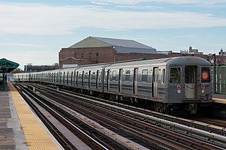
D train terminating at Coney Island–Stillwell Avenue
The new station's infrastructure includes a soaring roof with arches reminiscent of grand European railway stations such as the Gare Saint-Lazare and the Paddington railway station.[32] The roof is glazed with photovoltaic (solar electric) panels, consisting of 2,730 thin-film modules from Schott AG,[80] which cover about 76,000 square feet (7,100m2).[81] The solar panel system has a nominal capacity of about 210 kWp;[82][83] this equates to an annual output of 250,000kWh.[82] The solar panels provide about 15 percent of the station's power.[16][84] Although the solar roof cost about $4 million more than a glass roof of the same size, the MTA believed that the panels would save money in the long run.[84]
Due to their location near the beachfront, the station roof's solar panels needed to meet stringent hurricane standards. To meet those standards, the panels for the station were rigorously tested in a laboratory in York, Pennsylvania.[82] This makes Stillwell Avenue the first solar-powered subway station in the New York City Subway system.[44] The solar panels were expected to last for at least 35 years, and a catwalk is located below the roof if any solar panel replacements were ever needed.[82] As a bonus feature, a low voltage current, which is emitted from the panels, serves as a deterrent against pigeons.[82]
At the time of the panels' installation, Con Edison did not generally allow solar systems to be designed to feed energy back into its grid. As a result, output never exceeds demand, and much of the power produced on sunny days is wasted.[82][85]
Services and tracks
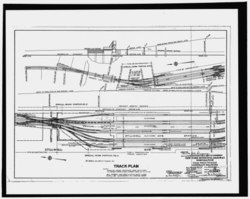
Track plan as proposed in 1915, showing all tracks as through tracks. This image is oriented 90 degrees clockwise from north, so that the image shows the eastward view of the track plan
Each line has its own pair of tracks and a pair of double switches between these tracks, and each service has its own island platform serving these tracks. In regular operation, no service needs to cross over the tracks of another service. The tracks are numbered sequentially from east to west, with the N train at tracks 1 and 2; the Q at tracks 3 and 4; the F at tracks 5 and 6; and the D at tracks 7 and 8.[6] Tracks 1–6 can serve trains coming from both the north and south, while tracks 7–8 can only serve trains from the north, since they terminate at bumper blocks at the station's south end.[6][86] Until 1954, track 2 ended at a bumper block to the south, while track 7 merged with track 6 at the south end of the station.[86] The next stations to the north are Bay 50th Street for D trains, 86th Street for N trains, and West Eighth Street–New York Aquarium for F,<F>, andQ trains.[87]
Though designed as a through station, service has rarely been provided between tracks. Aside from service changes, only two services have been scheduled to run through the station. These brief services ran as follows:
NX Sea Beach "super-express" service (rush hours 1967–1968)[90][91]
North of the station, tracks 7 and 6 merge into one track (with a switch from track 7 to track 8), tracks 5 through 2 merge into another track, and tracks 1 and 8 stay separate, so that there is a four-tracked structure when the BMT West End Line and BMT Sea Beach Line cross the Coney Island Creek. Before the structure crosses the creek, all four tracks have switches that connect the tracks to each other, before the West End and Sea Beach Lines split. Tracks from these lines then lead into Coney Island Yard.[6] South of the station, tracks 4, 5, and 6 stay separate from the other tracks (with a pair of switches between tracks 5 and 6) and tracks 1, 2, and 3 merge and have a diamond crossover with track 4. Tracks 3 and 4 (the Brighton Line tracks) are above tracks 5 and 6 (the Culver Line tracks) at this point.[6]
Located underneath the subway station terminal is a set of bus stops that loop on Stillwell Avenue and Mermaid Avenue that make up a bus terminal for four New York City Bus lines. The bus terminal provides easier transfer to the subway and bus connections. One additional bus line is located near the station complex.[78][92]
To reduce missed connections and waiting time between the B36 and B82 buses and the Qtrain, New York City Transit began operating yellow holding lights to signal bus operators to wait for imminently arriving trains. The lights, which began operating March 10, 2014, are on the northeast corner of Surf and Stillwell Avenues and in the Mermaid Avenue Bus Loop. This system operates during late nights, from 11:00 p.m. to 5:00 a.m. daily.[93]
Nearby points of interest
Track 8 platform with the Parachute Jump in the background
Slightly to the west is Maimonides Park, home park of the Brooklyn Cyclones, a minor league baseball team. [78][70] The nearby area also has assorted amusement park attractions, such as bumper cars, carousels, and ice skating rinks, especially along Surf Avenue.[94] The Parachute Jump, a former parachute-drop ride later converted into a lighted tower,[95] is nearby and visible from the station.[78] In addition, the seasonal Coney Island Mermaid Parade is held every summer near the station.[70][96] The Nathan's Hot Dog Eating Contest, held on July 4 each year, also takes place at the Nathan's shop, diagonally across the intersection of Surf and Stillwell Avenues on the southwest corner.[97][98] The former Shore Theater is located on the northwest corner of that intersection, west of the station and north of Nathan's Famous.[78]
Notes
↑ The track crossovers for the F,<F>, andQtrains are located between West 8th Street and Stillwell Avenue.[6]
Related Research Articles
The Q Second Avenue/Broadway Express/Brighton Local is a rapid transit service in the B Division of the New York City Subway. Its route emblem, or "bullet", is colored yellow since it is a part of the BMT Broadway Line in Manhattan.
The BMT Brighton Line, also known as the Brighton Beach Line, is a rapid transit line in the B Division of the New York City Subway in Brooklyn, New York City, United States. Local service is provided at all times by the Q train, but is joined by the B express train on weekdays. The Q train runs the length of the entire line from Coney Island–Stillwell Avenue to the Manhattan Bridge south tracks. The B begins at Brighton Beach and runs via the bridge's north tracks.
The W Broadway Local is a rapid transit service of the New York City Subway's B Division. Its route emblem, or "bullet", is colored yellow since it uses the BMT Broadway Line in Manhattan.
The Chrystie Street Connection is a set of New York City Subway tunnels running the length of Chrystie Street on the Lower East Side of Manhattan. It is one of the few track connections between lines of the former Brooklyn–Manhattan Transit Corporation (BMT) and Independent Subway System (IND) divisions, which together constitute the system's B Division. A major branch of the IND Sixth Avenue Line, it connects the Sixth Avenue Line to the BMT Brighton Line and BMT Fourth Avenue Line via the north side of the Manhattan Bridge and to the BMT Jamaica Line over the Williamsburg Bridge. The project, opened in 1967 and 1968, also includes the Sixth Avenue Line's Grand Street and 57th Street stations, the latter of which is not part of the connection itself.
The Ocean Parkway station is an express station on the New York City Subway's BMT Brighton Line. It is located at Brighton Beach Avenue and Ocean Parkway in Brighton Beach, Brooklyn. The station is served by the Q train at all times.
The IND Culver Line is a rapid transit line of the B Division of the New York City Subway, extending from Downtown Brooklyn south to Coney Island, Brooklyn, New York City, United States. The local tracks of the Culver Line are served by the F service, as well as the G between Bergen Street and Church Avenue. The express tracks north of Church Avenue are used by the <F> train during rush hours in the peak direction. The peak-direction express track between Ditmas Avenue and Avenue X has not seen regular service since 1987.
The D Sixth Avenue Express is a rapid transit service in the B Division of the New York City Subway. Its route emblem, or "bullet", is colored orange, since it uses the IND Sixth Avenue Line in Manhattan.
The F and <F> Queens Boulevard Express/Sixth Avenue Local are two rapid transit services in the B Division of the New York City Subway. Their route bullets are colored orange, since they use and are part of the IND Sixth Avenue Line in Manhattan.
The N Broadway Express is a rapid transit service in the B Division of the New York City Subway. Its route emblem, or "bullet," is colored yellow, since it uses the BMT Broadway Line in Manhattan.
The BMT Sea Beach Line is a rapid transit line of the BMT division of the New York City Subway, connecting the BMT Fourth Avenue Line at 59th Street via a four-track wide open cut to Coney Island in Brooklyn. It has at times hosted the fastest express service between Manhattan and Coney Island, since there are no express stations along the entire stretch, but now carries only local trains on the N service, which serves the entire line at all times. During rush hours, several W trains serve the line north of 86th Street.
The Church Avenue station is an express station on the IND Culver Line of the New York City Subway. Located at Church and McDonald Avenues in Kensington, Brooklyn, it is served by the F and G trains at all times, and by the <F> train during rush hours in the peak direction.
The Seventh Avenue station is an express station on the IND Culver Line of the New York City Subway, located at Seventh Avenue and Ninth Street in the Park Slope neighborhood of Brooklyn. It is served by the F and G trains at all times, and by the <F> train during rush hours in the peak direction.
The West Eighth Street–New York Aquarium station is a New York City Subway station, located on the BMT Brighton Line and IND Culver Line in the Coney Island neighborhood of Brooklyn. The station is located over the private right-of-way of the defunct New York and Coney Island Railroad north of Surf Avenue, running easterly from West 8th Street. It is served by the F and Q trains at all times, and by the <F> train during rush hours in the peak direction. This station is geographically the southernmost station in the entire New York City Subway system.
The 86th Street station is a local station on the BMT Sea Beach Line of the New York City Subway, located at the intersection of 86th Street and West Seventh Street in Gravesend, Brooklyn. It is served by the N train at all times. During rush hours, several W trains also serve the station, which serves as the southern terminus for W trips to Brooklyn.
The Fort Hamilton Parkway station is a local station on the IND Culver Line of the New York City Subway. It is served by the F and G trains at all times.
The Avenue X station is a local station in the Gravesend neighborhood of Brooklyn on the IND Culver Line of the New York City Subway. It is served by the F train at all times and the <F> train during rush hours in the peak direction.
The Neptune Avenue station is a station on the IND Culver Line of the New York City Subway, located in Coney Island, Brooklyn, at the intersection of Neptune Avenue and West 6th Street. It is served by the F train at all times and the <F> train during rush hours in the peak direction.
The Ninth Avenue station is a bi-level express station on the BMT West End Line of the New York City Subway, located at the intersection of Ninth Avenue and 39th Street in Brooklyn. Each level has three tracks and two island platforms. The upper level serves the BMT West End Line while the lower level formerly served the BMT Culver Line. Only the upper level is still in service and is served by the D train at all times.
The Atlantic Avenue–Barclays Center station is a New York City Subway station complex shared by the BMT Fourth Avenue Line, the BMT Brighton Line and the IRT Eastern Parkway Line. Named after Atlantic Avenue and the Barclays Center arena, it is located at Fourth and Flatbush Avenues' intersections with Atlantic Avenue and Pacific Street in Downtown Brooklyn. The complex is served by the 2, 4, D, N, Q and R trains at all times; the 3 train at all times except late nights; the 5 and B trains on weekdays during the day; and a few rush-hour W trains.
The Fourth Avenue/Ninth Street station is a New York City Subway station complex shared by the elevated IND Culver Line and the underground BMT Fourth Avenue Line. It is located at the intersection of Ninth Street and Fourth Avenue in Park Slope, Brooklyn and served by the:
1 2 "New York City Transit— History and Chronology". mta.info. Retrieved August 15, 2016. The newly renovated Stillwell Avenue Terminal reopens and train service returns to Coney Island after a 21-month hiatus during construction
↑ Kurtz, Howard (March 31, 1893). "Renovation Threatens to Gobble Up Coney Island Candy Man". The Washington Post. p.2. ISSN0190-8286. ProQuest307074967.
↑ Farrell, Bill (September 4, 2002). "Station Fixup to Curb Service to Coney Island". New York Daily News. p.4. ISSN2692-1251. ProQuest305756241.
1 2 Jain, Anita (August 2, 2004). "Coney Island tracks success to trains". Crain's New York Business. Vol.20, no.31. p.12. ProQuest219212244.
1 2 Grace, Melissa (April 23, 2004). "Coney Biz Owners Rail Happy Q, F Lines Resume Service to Stillwell Ave". New York Daily News. p.1. ISSN2692-1251. ProQuest305878120.
↑ Hays, Elizabeth (August 7, 2001). "Subway Repair May Impair Coney Biz". New York Daily News. p.1. ISSN2692-1251. ProQuest305637501.
↑ Monahan, Rachel (July 11, 2007). "Subway Ease for Disabled. Atlantic Ave. Station Now Boasts Better Access but Advocates Push for More Station Upgrades". New York Daily News. p.45. ISSN2692-1251. ProQuest306124308.
1 2 Robin, Joshua (November 14, 2003). "Bright Idea for B'klyn Subway Station / Innovative solar shield to generate energy". Newsday. p.A04. ISSN2574-5298. ProQuest279755074.
1 2 "Brighton Line Track Plans"(PDF). Electric Railroaders' Association Bulletin. 46 (7): 5. July 2003. Archived from the original(PDF) on September 7, 2018. Retrieved April 10, 2018.
Note: Service variations, station closures, and reroutes are not reflected here. Stations with asterisks have no regular peak, reverse peak, or midday service on that route. See linked articles for more information.
Stations and line segments in italics are closed, demolished, or planned (temporary closures are marked with asterisks). Track connections to other lines' terminals are displayed in brackets. Struck through passenger track connections are closed or unused in regular service.
This page is based on this Wikipedia article Text is available under the CC BY-SA 4.0 license; additional terms may apply. Images, videos and audio are available under their respective licenses.