
The Plains is a town in Fauquier County, Virginia, United States. The population was 217 at the 2010 census, down from 266 at the 2000 census. It is centered on the intersection of Virginia Route 55 and Virginia Route 245. The town of The Plains is situated off Interstate 66. The mayor of The Plains is Blake Gallagher.

Bluefield is a town in Tazewell County, Virginia, United States, located along the Bluestone River. The population was 5,444 at the 2010 census. It is part of the Bluefield WV-VA micropolitan area which has a population of 107,342. The micropolitan area is the 350th largest statistical population area in the United States.

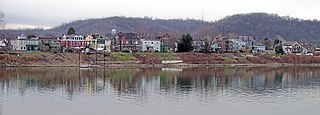
Pocahontas is a town in Tazewell County, Virginia, United States. It was named for Chief Powhatan's daughter, Pocahontas, who lived in the 17th-century Jamestown Settlement. She married John Rolfe, and they were among the ancestors of many of the First Families of Virginia.

West Union, incorporated July 20, 1881, is a town in Doddridge County, West Virginia, United States. The population was 825 at the 2010 census. It is the county seat of Doddridge County. The mayor is Joseph Thorpe as of 2013. The town is located along Middle Island Creek at the junction of U.S. Route 50 and West Virginia Route 18; the North Bend Rail Trail also passes through the town.

Ansted is a town in Fayette County in the U.S. state of West Virginia. The population was 1,404 at the 2010 census. It is situated on high bluffs along U.S. Route 60 on a portion of the Midland Trail a National Scenic Byway near Hawk's Nest overlooking the New River far below.

Romney is a city in and the county seat of Hampshire County, West Virginia, USA. The population was 1,940 at the 2000 census, while the area covered by the city's ZIP code had a population of 5,873. The population was 1,848 at the 2010 census.

Weston is a city in Lewis County, West Virginia, United States. The population was 4,110 at the 2010 census. It is the county seat of Lewis County, and home to the Museum of American Glass in West Virginia and the Trans-Allegheny Lunatic Asylum.

Skyline Drive is a 105-mile (169 km) road that runs the entire length of the National Park Service's Shenandoah National Park in the Blue Ridge Mountains of Virginia, generally along the ridge of the mountains. The drive's northern terminus is at an intersection with U.S. Route 340 near Front Royal, and the southern terminus is at an interchange with US 250 near Interstate 64 (I-64) in Rockfish Gap, where the road continues south as the Blue Ridge Parkway. The road has intermediate interchanges with US 211 in Thornton Gap and US 33 in Swift Run Gap. Skyline Drive is part of Virginia State Route 48, which also includes the Virginia portion of the Blue Ridge Parkway, but this designation is not signed.

The National Register of Historic Places in the United States is a register including buildings, sites, structures, districts, and objects. The Register automatically includes all National Historic Landmarks as well as all historic areas administered by the U.S. National Park Service. Since its introduction in 1966, more than 90,000 separate listings have been added to the register.
The Washington Heritage Trail is a 136.0-mile (218.9 km) National Scenic Byway through the easternmost counties of West Virginia's Eastern Panhandle. The trail forms a loop through the three counties and traces the footsteps of George Washington and the marks his family left in the Eastern Panhandle. In addition to homes and sites related to the Washingtons, the Washington Heritage Trail also includes various museums, historic districts, parks, and other sites of historic significance in the area.
Wheeling Island is the most populated island in the Ohio River. It lies within the city of Wheeling in Ohio County, West Virginia, in the United States. The 2000 census showed a resident population of 3,142 people on the island, which has a land area of 1.514 km2. Neville Island, PA is larger (3.4 km2) but has fewer people (1,232).

Shanghai is an unincorporated community in Berkeley County, West Virginia. The town is nestled in Back Creek Valley between Leading Ridge and North Mountain. Shanghai lies at the junction of West Virginia Secondary Route 7 and Secondary Route 18.

Institute is an unincorporated community on the Kanawha River in Kanawha County, West Virginia, United States. Interstate 64 and West Virginia Route 25 pass by the community, which has grown to intermingle with nearby Dunbar. Institute is home to West Virginia State University and the West Virginia State Police Academy. In August 2008 a chemical plant explosion here killed two and injured eight at the Bayer CropScience facility.

State Route 45 is a primary state highway in the U.S. state of Virginia. The state highway runs 39.72 miles (63.92 km) from the junction of U.S. Route 15 Business and US 460 Business in Farmville north to SR 6 at Georges Tavern. SR 45 is the primary north–south highway of Cumberland County, where the highway meets US 60 near the county seat, Cumberland.
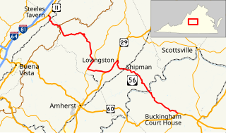
State Route 56 is a primary state highway in the U.S. state of Virginia. The state highway runs 60.87 miles (97.96 km) from U.S. Route 11 at Steeles Tavern east to US 60 near Buckingham. SR 56 is the main east–west highway of Nelson County. The state highway connects the county seat of Lovingston with Buckingham to the east and the Blue Ridge Mountains and the Shenandoah Valley to the west.
Glen Jean is a census-designated place (CDP) in Fayette County, West Virginia, United States, near Oak Hill. As of the 2010 census, its population is 210.
Frankford is an unincorporated community in Greenbrier County, West Virginia, United States. Frankford is located on U.S. Route 219 south of Falling Spring and north of Maxwelton. Frankford has a post office with ZIP code 24938.

